
< more recent | 1-7 May 2021 | older >
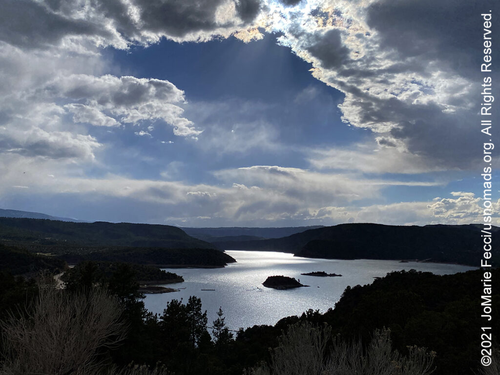
7 May 2021: Enjoyed sharing some trail time with Bill Burke, founder of BB4WD, and a corporate group he had been training this week at Tabegauche near Grand Junction before getting back on the highway in the afternoon heading north. The landscape began to change transitioning away from the desert and into mountains on the approach to the Flaming Gorge area. Made a short stop to visit the dam at the mouth of the gorge itself then finished the last leg to Rock Springs Wyoming…
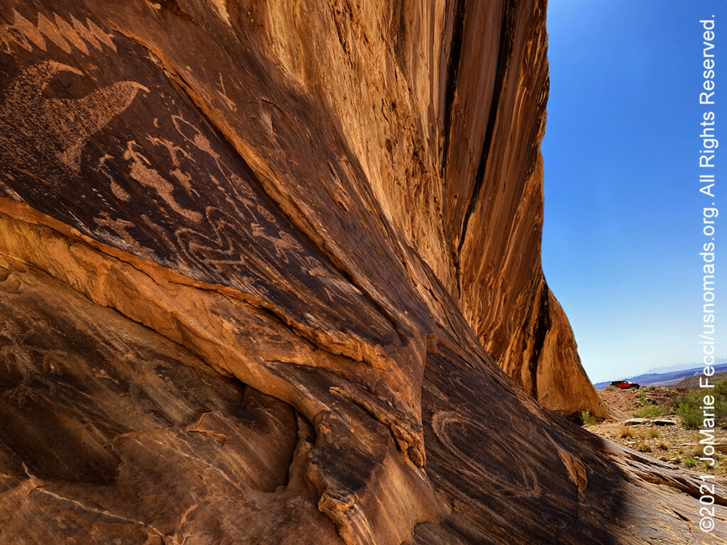
6 May 2021: Spent much of the day in the San Rafael Swell taking a spur trail that actually went right into the massive uplift to a place where sections of rock met with a small opening in between. There was water in a “pothole” there and many petroglyphs on the walls and at one point it seemed like the floor and wall became one and it was important to step carefully so as not to walk on an etching. After lingering in this spiritual place for a little while it was time to continue on to Black Dragon Canyon for more petrogyphs and a beautiful drive back through the heart of the Swell itself before picking up the highway to Grand Junction …
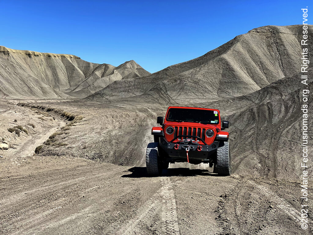
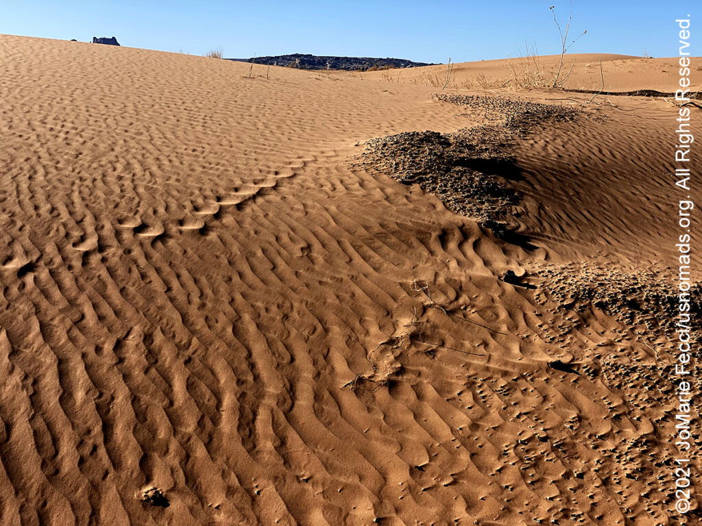
5 May 2021: Continued meandering along north-eastward, with some interesting stops to scout out for future possibilities in Capitol Reef. Had to go looking for marmots, though didn’t see any, then a quick stop to check out some easily accessible petroglyphs right along the road before picking up the Cathedral Valley Road trail at the Fremont River water crossing. On the way out of the monument came across an interesting OHV area in the seemingly lunar landscape badlands near Factory Butte. Spent a little time playing in this Swing Arm City OHV area before getting back on the road to Hanksville, and on into the San Rafael Swell…
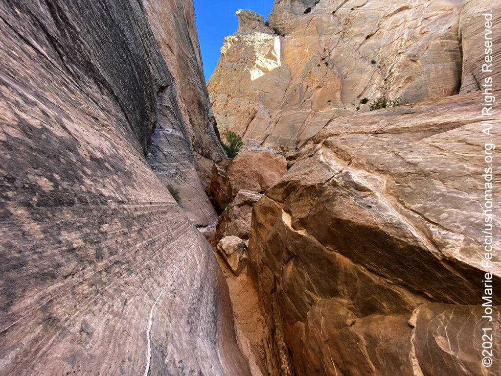
4 May 2021: Taking the slow scenic route for the start of the journey back to New York and decided to explore this remote area of Utah that has so many incredible otherworldly landscapes tucked in between mountains and desert. In the morning continued along Cottonwood Canyon Road with a stop to hike a slot canyon that looked inviting and another stop to check out an off-the-beaten-track arch. Then made a short detour into the Kodachrome Basin State Park (mostly because of the name–there wasn’t anything in the park that was any more spectacular than the landscape in the larger monument). From there picked up a stretch of pavement along Utah Scenic Byway 12 to Capitol Reef…
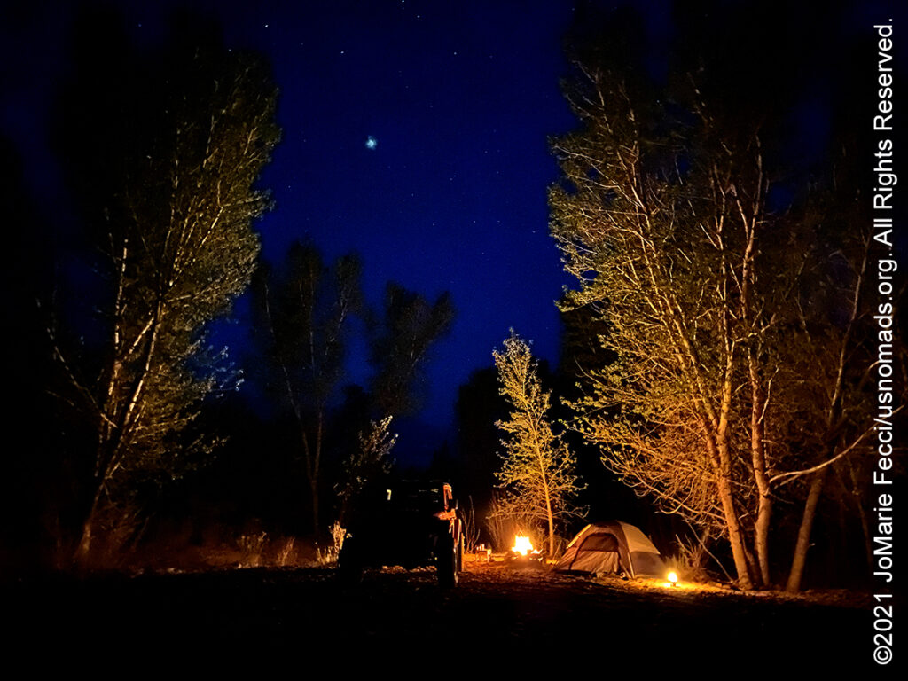
3 May 2021: Continued the drive north bound heading back to Page and crossing into Utah over the Glen Canyon Dam then picking up Cottonwood Canyon Road a very scenic dirt road that runs through the Grande Escalante National Monument. Got to see some long horn cattle grazing on the open range land and set up camp in a beautiful little spot under the trees near a stream …
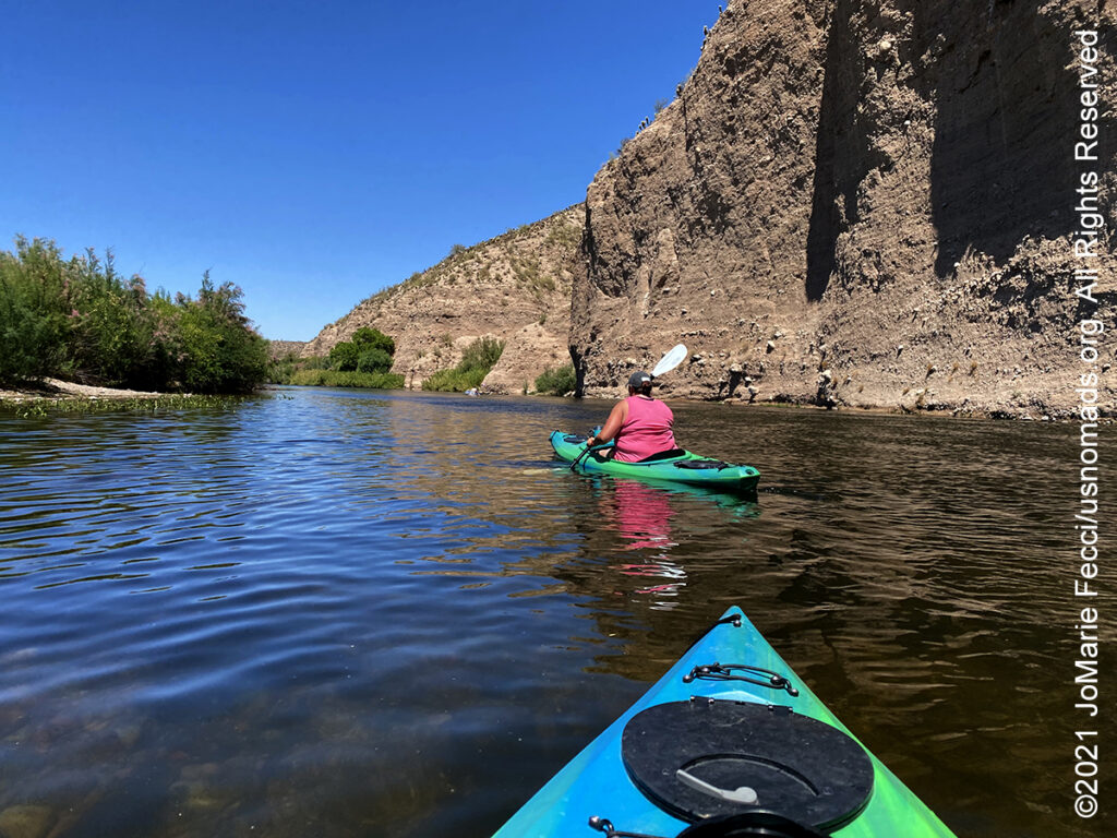
2 May 2021: From dirt to water–some members of our Ladies Offroad Network 5+ edition group stayed on for a bonus day paddling the Salt River. The impromptu kayak trip was a nice mellow 12-mile paddle downriver through some beautiful desert terrain. A bit strange to be kayaking in the land of the saguaro, but a really fun and different way to experience this area. At the end of the day started the drive north, the beginning of the “return” route…
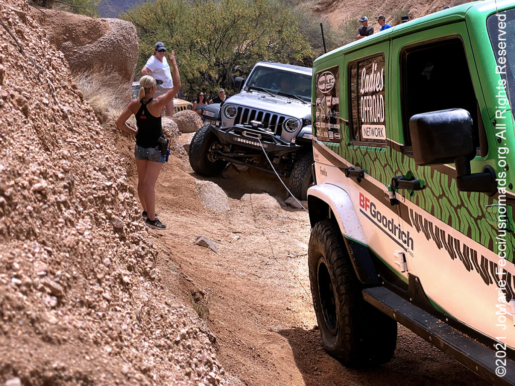
1 May 2021: Finished up the “5+ Edition” with a tough one today. This section of FR160, known as Rocker Panel Pass, is a narrow gauntlet of twists, climbs and rocks only 1/2 mile long, but it took us all day to get the group of Jeeps out of it (keeping them in all in one piece). We used our winches and some very creative rock stacking (not to mentioned extremely nuanced spotting) to get the Jeeps over terrain that looked truly impassible …
THIS MONTH:
![]()
Taking part in the 6th Annual 2021 Ladies Offroad Challenge which runs from May through July. This year’s challenge continues the fun and exciting format from 2019. Participants take on a series of 11 Challenges that have different deadlines spanning over 10 weeks. These offroad based challenges will tap into each persons skills, tools, heart and mind. They are built to be fun and everyone should find at least one challenge activity that pushes them outside their comfort zone. Participants have different ways to earn a spot in a “Top Ten Weekend” where 10 ladies join Charlene Bower for a 4-day epic weekend experience…
COMING UP SOON:

Every Day Is a Clean Up Day in 2021. Ladies Offroad Network has partnered with TreadLightly! to create a year-long program that encourages members to pick up trash on the trails whenever they are out off-roading. Participants simply pick up the trash, weigh it, take a photo, and log the location and time it took, then upload the details. At the end of the year there will be a series of prizes based on pounds of trash removed from the trails as well as participation in other TreadLightly! initiatives. This is a great way to do some good on a local level and make a larger impact via the national program…

Looking ahead to a return to Paris as soon as possible to reconnect with friends and some favorite places in the city of light. Timing is still uncertain due to the pandemic, but we hope the trip is back on the calendar for early 2021…
THE SAN RAFAEL DESERT
Much of the area around the San Rafael Swell is remote and aside from Interstate (1-70), is mostly undeveloped with only old uranium mines, dirt roads and some simple recreation facilities. The BLM advises visitors to bring maps, as many roads are not signed. Additionally, the BLM reminds those traveling in the desert of some basic safety precautions: Never camp or park your vehicle in a wash or stream bed and avoid hiking in narrow canyons when rain is a possibility. A dry wash can flash flood in a matter of minutes even if you don’t see a cloud in the sky. Many roads within the Swell cross soil types that are extremely muddy after storms and during periods when snow is melting. At such times, these roads become virtually impassable. Obtain a long-range weather forecast before traveling into the area. There are very few sources of potable water in the San Rafael Swell, so make sure to carry at least one gallon of water per person per day…
CAPITOL REEF
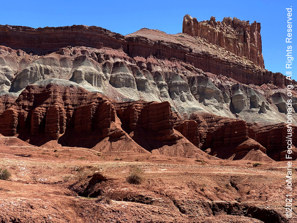
Capitol Reef National Park, in south-central Utah, was established to preserve 241,904 acres of desert landscape. The park is long and narrow, approximately 60 miles long on its north–south axis and just 6 miles wide on average. Capitol Reef was first designated a national monument on August 2, 1937, by President Franklin D. Roosevelt to protect the area’s colorful canyons, ridges, buttes, and monoliths; however, it was not until 1950 that the area officially opened to the public. The park’s name sometimes causes confusion because most people think of a “reef” as being in an ocean, not an arid desert. But locally, the term “reef” refers to any rocky barrier to land travel, just as ocean reefs are barriers to sea travel. And “capitol” comes from the whitish Navajo Sandstone cliffs with dome formations that run from the Fremont River to Pleasant Creek on the Waterpocket Fold—-which seemed similar to the white domes often placed on capitol buildings. Capitol Reef encompasses the Waterpocket Fold, a warp in the earth’s crust that is 65 million years old. It is the largest exposed monocline in North America. In this fold, newer and older layers of earth folded over each other in an S-shape. This warp, probably caused by the same colliding continental plates that created the Rocky Mountains, has weathered and eroded over millennia to expose layers of rock and fossils. The park is filled with brilliantly colored sandstone cliffs, gleaming white domes, and contrasting layers of stone and earth. The fold forms a north-to-south barrier that has barely been breached by roads. The first paved road was only constructed through the area in 1962. State Route 24 cuts through the park traveling east and west between Canyonlands National Park and Bryce Canyon National Park, but few other paved roads invade the rugged landscape. The park is filled with canyons, cliffs, towers, domes, and arches. Hundreds of miles of trails and unpaved roads lead into the equally scenic backcountry…
GRANDE ESCALANTE
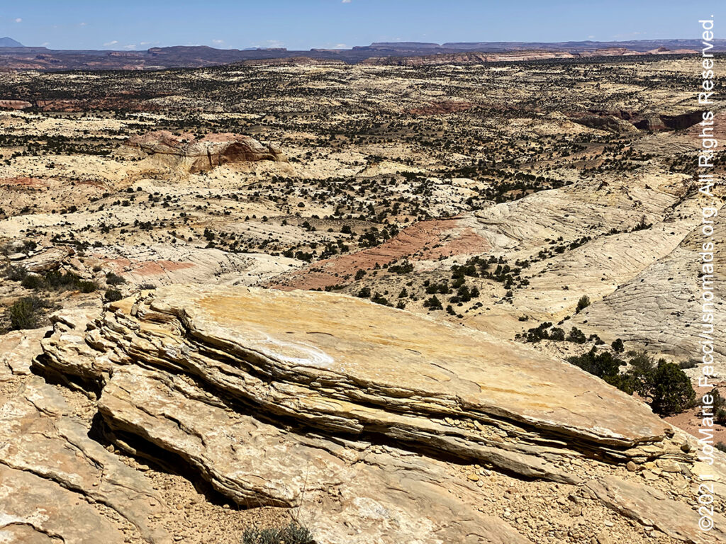
The Grand Staircase–Escalante National Monument in southern Utah is among the most remote in the country–it was the last region to be mapped in the contiguous United States. The Monument is a diverse geologic treasure speckled with monoliths, slot canyons, natural bridges, and arches. President Bill Clinton set it aside as a national monument in 1996 because its untrammeled significance distinguishes it for researchers and explorers alike. A 200-million-year-old staircase that is like a museum of sedimentary erosion, it tells the story of animals, minerals and vegetables through time. The monument spans five life-zones – from low-lying desert to coniferous forest. Deep within this vast and austere landscape, the Anasazi and Fremont cultures made contact in the period AD 950-1100, leaving behind rock art panels, occupation sites, campsites and granaries. Stepping further back in time, fossil excavations have yielded more information about ecosystem change at the end of the dinosaur era than any other place in the world. It’s also a big empty playground for off-roaders, canyoneers and hikers with many jeep trails, cliffs and other photo-hungry rock forms across 1.9 million acres. There monument is divided into three main regions: the Grand Staircase, the Kaiparowits Plateau, and the Canyons of the Escalante River. The Grand Staircase is named for the series of plateaus that descend from Bryce Canyon south toward the Grand Canyon, marked by vertical drops at the Pink Cliffs, Grey Cliffs, White Cliffs, Vermillion Cliffs and Chocolate Cliffs. The Kaiparowits Plateau, at nine thousand feet, is the highest, wildest, most arid, most remote part of the monument. It’s a big gray-green scalene triangle pointing north to Escalante on Highway 12, chock full of Late Cretaceous fossils. The Canyons of the Escalante are a rugged, desolate paradise–it’s the rocky bones laid bare after the Escalante River gnawed through earth’s flesh, an exquisite corpse of narrow canyons, towering walls and stunning grottoes. Travel within the Monument can be very unforgiving, and its wild character should not be underestimated. Before beginning any of Monument adventures, make sure to plan a way in, and a way out. Know the extended weather forecast and carry extra clothing, blankets, food and water for emergencies — cell phone coverage across the Monument is sparse if at all…
Nesconset | Paris | Belgrade | Akron | St. Louis | Clinton | Grants | Yuma | Borrego Springs | Laughlin | Baker | Barstow | Ridgecrest | Lone Pine | Death Valley | Beatty | Sedona | Phoenix

MORE NOTES FROM THE ROAD:
23-30 April – LON Bogi’s & 5+
16-22 April – LON Navigation
8-15 April – Sedona
1-7 April – Nevada
16-31 March – New York
8-15 March – Death Valley
1-7 March – Arizona
22-28 Februay – Alabama Hills
15-21 Februay – Mojave Road
8-14 Februay – Death Valley
1-7 Februay – Glamis
15-31 January – Roadtrip Southwest
1-14 January – Long Island
22-31 December – Holiday Roadtrip
15-21 December – Holiday Roadtrip
7-14 December – Holiday Roadtrip
1-6 December – Long Island
15-30 November – Long Island
1-14 November – Long Island
28-31 October – Roadtrip East
22-27 October – Moab
15-21 October – Moab
8-14 October – Moab
1-7 October – Roadtrip West
16-30 September – Roadtrip West
1-15 September – Long Island
16-31 August – Long Island
1-15 August – Summer Roadtrip
22-31 July – Summer Roadtrip
14-21 July – Summer Roadtrip
1-13 July – Long Island
16-30 June – Long Island
1-15 June – Bald Eagle
16-31 May – Central PA
1-15 May – Re-opening Trails
April – Lockdown NY
Archive
EVENTS
LADIES OFFROAD NETWORK NONCON 2020
Recap from the Ladies Offroad Network camping and wheeling event, dubbed the “NonCon” as in “not the convention,” that came together after the official convention was cancelled due to the pandemic… [read]
RE-OPENING
Report from the first trail run with the Off Road Consulting group at Rausch Creek Off Road Park as the post-pandemic phased re-openings begin in Pennsylvania and some of our favorite local trails re-open to the public after the two-month shutdown… [read]
REFLECTIONS

EGYPT: CAIRO REFLECTIONS
A quick overview of impressions from a stop in Cairo during our recent scouting mission in Egypt and Sudan … [read]
SPECIAL REPORT

A look into south-eastern Algeria on the border with Libya and Niger: overlanding with the Tuareg in one of the most remote corners of the Sahara … [read]