
< more recent | 8-15 May 2021 | older >

15 May 2021: Had a wonderful last night under the stars and woke up a little “late” this morning to the soothing sounds of the stream. Packed up camp for the last time and loaded everything into the Jeep to start on the road to home. Traffic was light across Pennsylvania and into New Jersey, only becoming bottlenecked on the approach to New York. There were a few drops of rain and the sky was unsettled before the sun asserted itself. Made it across the last bridge to Long Island with plenty of daylight and it felt good to be home …
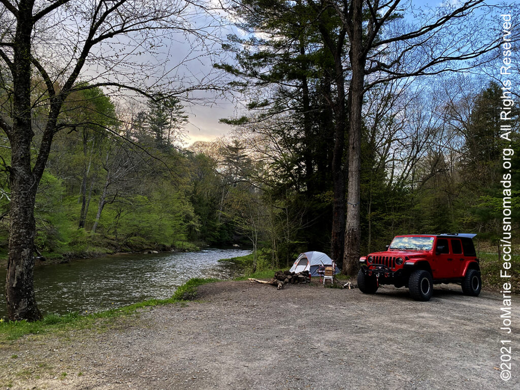
14 May 2021: Continued the drive through Ohio making a stop at the Cuyahoga Valley National Park for a short hike. Walked a bit on the Towpath trail by the scenic railway but it was very crowded so decided to look for someplace less frequented and settled on the Beaver Marsh further south. The marsh trail was a nice easy walk and there were fewer people. Had hoped to maybe see a beaver, but there were none to be seen in the middle of the afternoon. Got back on the road and headed towards Pennsylvania with the hope to do a last night of dispersed camping. Identified a good area in the Allegheny National Forest and arrived a little before sunset. There was only one spot left to camp, and even though it was somewhat close to the road, it was a nice campsite with a rock fire ring. Set up the tent next to the stream and got the fire started as the sun went down…
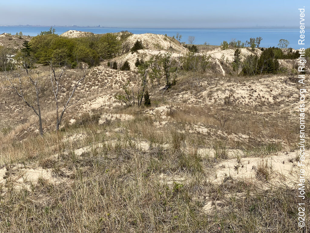
13 May 2021: Wanted to check out the dunes and was hoping for something similar to desert dunes, but next to water. Instead these dunes are “forested” and covered by grasses for the most part, making them much less dramatic visually. Still, went to explore on of the tall ones, “Diana’s Dune” that had a nice overview before getting back on the road and making up some miles deep into Ohio …
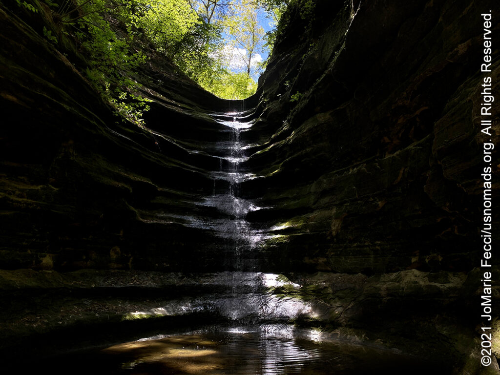
12 May 2021: In the morning went for a hike and had no “expectations” of anything more than a short walk in the woods. Was pleasantly surprised by two things — first, the fact that this part of Iowa was not actually completely flat, and second, that there was a really cool rock formation to explore in the woods. From Wildcat Den got back on the road and hustled to make some distance in good time so it was possible to make another “hike stop” at Starved Rock state park in Illinois. The hike there was to a waterfall at the end of a slot canyon. Both of the day’s hikes were remarkable for the lush green everywhere around, perhaps it was just the contrast with the colors of the desert after so long. Made a final stretch of road into Indiana and set up camp at the Indiana Dunes state park on the edge of Lake Michigan…
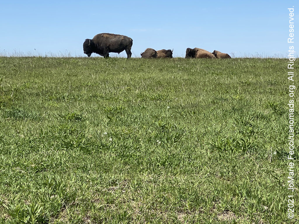
11 May 2021: Broke camp early and got back on the road, driving into Iowa and making a short detour to the Neal Smith National Wildlife Refuge to see the Buffalo herd there. The buffalo were lazily grazing on green grass that looked like a giant lawn. The surrounding farmlands were beginning to plant and there was so much green everywhere. Decided to camp at a state park called Wildcat Den that had a small campground which was very well manicured and didn’t seem so very wild …
10 May 2021: Managed to stay barely ahead of the storm, driving in rain instead of snow for much of the day. It was a strange day, sort of like a “goodbye” to the west as the landscape transitioned midway through Nebraska back to a more “eastern” feel. The “midwest” being this flat transition zone of endless farmland. Stopped for a walk at the Kearney Archway attraction, and it felt strange to see this “fake” representation of the history we have just spent three months driving through. The Archway does its best to tell the story of western expansion “fairly” in their interpretive panels on the outdoor walkway, but after delving so deeply into the archeaology and anthropology of the “west” during the whole journey it seemed so flat and cliched. The rain let up by late afternoon, though the sky was still unsettled, and we drove as far as Grand Island, setting up camp on the shore of the little lake at Mormon Island for the night …
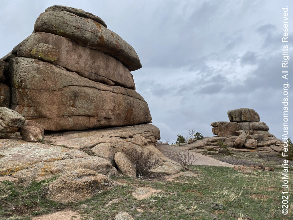
9 May 2021: The weather was still bad and there was a big snowstorm forecast to come in, so no point in trying to stay longer. Did get to go for a hike to see the White Mountain Petroglyphs and looped out to the Killpecker Sand Dunes OHV area before leaving the Red Desert and heading for Vedauwoo in the Medicine-Bow National Forest. The snow caught up with us at Vedauwoo, just beginning to fall in big wet flakes. It didn’t matter because Vedauwoo was “closed”. Took a short walk around the fence to make some photos but it was cold and wet and a good idea to get as far ahead of the storm as possible, so drove on, making it just across the border into Nebraska before stopping for the night …
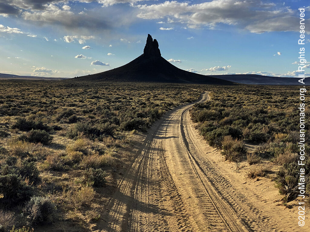
8 May 2021: It was cold and windy this morning so had to adapt the plan slightly, starting with a drive out to Pilot Butte to try to see some of the wild horses there. Only saw three of them grazing, but did get to see a small herd of antelopes from a distance, which was cool. After driving the wild horse “loop” and seeing so few of them, we tried the BLM’s Rock Springs Wild Horse Holding Facility, where it was definitely possible to see horsed — but it was kind of sad as they were all fenced in to a small area with a double set of fences topped with barbed wire (almost like a concentration camp for horses). Went back out into the desert to the Boar’s Tusk rock formation and towards the sand dunes wilderness area later in the day…
THIS MONTH:
![]()
Taking part in the 6th Annual 2021 Ladies Offroad Challenge which runs from May through July. This year’s challenge continues the fun and exciting format from 2019. Participants take on a series of 11 Challenges that have different deadlines spanning over 10 weeks. These offroad based challenges will tap into each persons skills, tools, heart and mind. They are built to be fun and everyone should find at least one challenge activity that pushes them outside their comfort zone. Participants have different ways to earn a spot in a “Top Ten Weekend” where 10 ladies join Charlene Bower for a 4-day epic weekend experience…
COMING UP SOON:

Every Day Is a Clean Up Day in 2021. Ladies Offroad Network has partnered with TreadLightly! to create a year-long program that encourages members to pick up trash on the trails whenever they are out off-roading. Participants simply pick up the trash, weigh it, take a photo, and log the location and time it took, then upload the details. At the end of the year there will be a series of prizes based on pounds of trash removed from the trails as well as participation in other TreadLightly! initiatives. This is a great way to do some good on a local level and make a larger impact via the national program…

Looking ahead to a return to Paris as soon as possible to reconnect with friends and some favorite places in the city of light. Timing is still uncertain due to the pandemic, but we hope the trip is back on the calendar for early 2021…
INDIANA DUNES
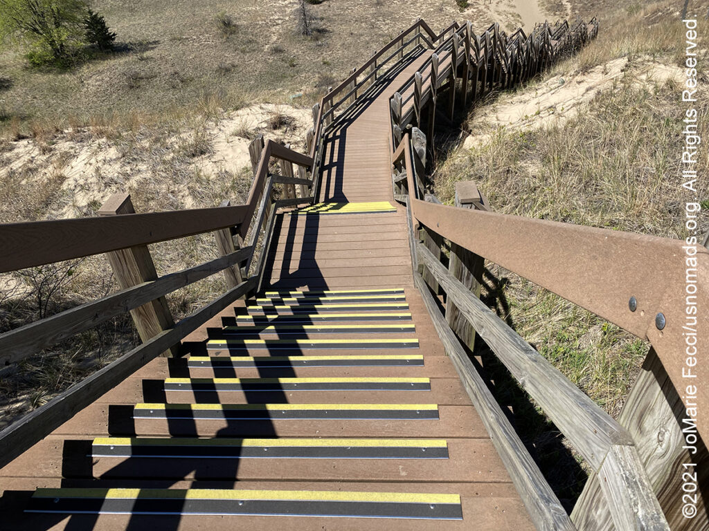
Indiana Dunes National Park, located in northwestern Indiana, runs for about 20 miles along the southern shore of Lake Michigan. There is little evidence of permanent Native American communities forming during the earlier years; rather, the evidence suggests that seasonal hunting camps were the norm. The earliest evidence for permanent camps was the occupation of the Ohio valley by the Hopewell culture. Five groups of mounds have been documented in the dunes area. These mounds are consistent with the period of 200 BCE to 800 CE, though even that was a short lived permanency. Beginning in the 1500s, European exploration and trade introduced more changes to the human environment. Tribal animosities and European competition affected tribal relations. Entire populations began moving westward, while others sought to dominate large geographic trading areas. Once again, the dunes became a middle point on a journey from the east or the west. It continued to remain a key hunting ground for villages over a wide area. It wasn’t until the 19th century that native villages once again were scattered through the area, but this was soon followed by European settlement. In the early 1900s most of the coastline has been settled for use as homes, factories, and businesses and the dunes became threatened by the encroaching real-estate development. An American intellectual, nonconformist, and free spirit, Alice Mabel Gray had been living in a crude shack along Indiana’s wild Lake Michigan shore and became interested in the history, ecology, and the need to preserve the area’s dunes. Later known as “Diana of the Dunes” she had trained in mathematics, astronomy, and classical languages at the University of Chicago in the early 1900s before rejecting a wage-earning, urban life in favor a solitary existence at the Indiana Dunes. Gray’s unconventional lifestyle fascinated the general public and area news reporters, who gave her the “Diana” moniker. Gray’s notoriety and the “Diana” legend brought media attention to the Dunes at an important time when the local community’s support was critical in helping to establish the area as a nature preserve that became the Indiana Dunes State Park and later Indiana Dunes National Park. Today visitors to the National Park can take the “Diana Dunes Dare” a hiking challenge that begins with a tall sprawling staircase to the top of “Diana’s Dune” where one can pause to gaze across the delicate, diverse rolling beauty of the dune succession and its fragility before continuing the hiking loop…
STARVED ROCK STATE PARK
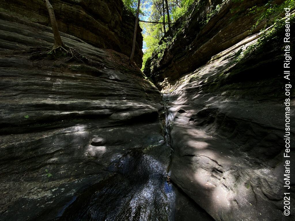
Starved Rock State Park is located just southeast of the village of Utica, IL, along the south bank of the Illinois River. The park has over 13 miles of hiking trails with 18 deep canyons, some of which feature dramatic waterfalls. The unique topography was created by a catastrophic flood from a melting glacier, approximately 14,000-17,000 years ago before humans occupied the area. The flood exposed the rock canyons which are very unusual for the central plains area. Starved Rock is named for a prominent sandstone butte that overlooks the river, where according to local legend, a group of Native Americans of the Illinois Confederation had fled under attack by the Ottawa and Potawatomi who besieged the butte until all of the Illiniwek had starved. The area around The Rock was designated a National Historic Landmark in 1960…
WHITE MOUNTAIN PETROGLYPHS
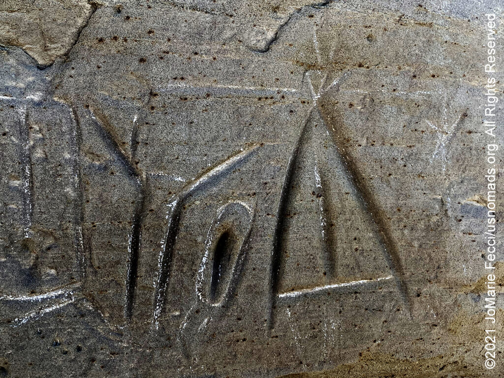
Hundreds of carved figures dot the sandstone cliffs at the White Mountain Petroglyphs site and range from 200 to 1000 years old. Etched into the sandstone bedrock of the Ecocene Bridger formation some 1,000 to 200 years ago, several figures appear to portray bison and elk hunts while others depict geometric forms or tiny footprints. The petroglyphs also include drawings of horses and riders with feather headdresses, teepees and several kinds of human figures. Contemporary Native American spiritual leaders believe these drawings were created for religious purposes and should be treated accordingly. Somewhat unique to this site are handprints worn into the rock as well, providing visitors with a compelling connection to those who used the site long ago. Some theorize that this area may have been a birthing place for the Plains and Great Basin native American people based on several of the drawings that depict animals within animals. It is possible that the handholds worn in the stone may have served for generations of women to grip the rock during labor. The site remains a sacred place for the Native American people, and visitors are asked to view the petroglyphs with reverence befitting their spiritual significance…
THE RED DESERT
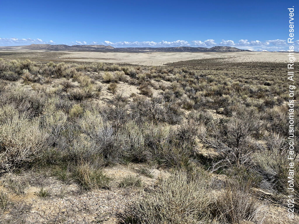
The Red Desert is a high altitude desert and sagebrush steppe located in south central Wyoming, comprising approximately 9,320 square miles. Among the natural features in the Red Desert region are the Great Divide Basin, a unique drainage basin formed by a division in the Continental Divide, and the Killpecker Sand Dunes, the largest living dune system in the United States. Scientists trace the story of human presence in the Red Desert back 12,000 years. Evidence of early human inhabitants is seen in rock art found at the Boars Tusk, East Flaming Gorge, and Seedskadee areas. Other pre-historic evidence include Native American artifacts estimated to be more than 10,000 years old found in the Killpecker Sand Dunes, often in company with bison bones. The Red Desert region served as a marketplace and crossroads of interaction between nomadic Plains Indians, including Blackfeet, Crows, and Shoshone into the historical period. In the 19th century, the Oregon, California and Mormon Trails crossed the Continental Divide at South Pass, just north of the Red Desert. Generations of American families left their mark upon the desert as they migrated westward along emigrant trails. The majority of the Red Desert is public land managed by the Rock Springs and Rawlins field offices of the U.S. Bureau of Land Management (BLM). The region is rich in oil, natural gas, uranium, and coal. An estimated 84% of the Red Desert has been “industrialized” by oil and gas drilling or by mining operations and associated roads. Nearly three-quarters of the area is covered by sagebrush grassland. Home to the largest unfenced area in the continental United States, the Red Desert supports an abundance of wildlife, despite its scarcity of water and vegetation. The largest migratory herd of pronghorn in the lower 48 states and a rare desert elk herd, said to be the world’s largest, live in the desert. Herds of feral horses roam the area in large numbers…
Nesconset | Paris | Belgrade | Akron | St. Louis | Clinton | Grants | Yuma | Borrego Springs | Laughlin | Baker | Barstow | Ridgecrest | Lone Pine | Death Valley | Beatty | Sedona | Phoenix

MORE NOTES FROM THE ROAD:
1-7 May – Southeast Utah
23-30 April – LON Bogi’s & 5+
16-22 April – LON Navigation
8-15 April – Sedona
1-7 April – Nevada
16-31 March – New York
8-15 March – Death Valley
1-7 March – Arizona
22-28 Februay – Alabama Hills
15-21 Februay – Mojave Road
8-14 Februay – Death Valley
1-7 Februay – Glamis
15-31 January – Roadtrip Southwest
1-14 January – Long Island
22-31 December – Holiday Roadtrip
15-21 December – Holiday Roadtrip
7-14 December – Holiday Roadtrip
1-6 December – Long Island
15-30 November – Long Island
1-14 November – Long Island
28-31 October – Roadtrip East
22-27 October – Moab
15-21 October – Moab
8-14 October – Moab
1-7 October – Roadtrip West
16-30 September – Roadtrip West
1-15 September – Long Island
16-31 August – Long Island
1-15 August – Summer Roadtrip
22-31 July – Summer Roadtrip
14-21 July – Summer Roadtrip
1-13 July – Long Island
16-30 June – Long Island
1-15 June – Bald Eagle
16-31 May – Central PA
1-15 May – Re-opening Trails
April – Lockdown NY
Archive
EVENTS

LADIES OFFROAD NETWORK NONCON 2020
Recap from the Ladies Offroad Network camping and wheeling event, dubbed the “NonCon” as in “not the convention,” that came together after the official convention was cancelled due to the pandemic… [read]
RE-OPENING
Report from the first trail run with the Off Road Consulting group at Rausch Creek Off Road Park as the post-pandemic phased re-openings begin in Pennsylvania and some of our favorite local trails re-open to the public after the two-month shutdown… [read]
REFLECTIONS

EGYPT: CAIRO REFLECTIONS
A quick overview of impressions from a stop in Cairo during our recent scouting mission in Egypt and Sudan … [read]
SPECIAL REPORT

A look into south-eastern Algeria on the border with Libya and Niger: overlanding with the Tuareg in one of the most remote corners of the Sahara … [read]