
< more recent | 1-7 October 2020 | older >
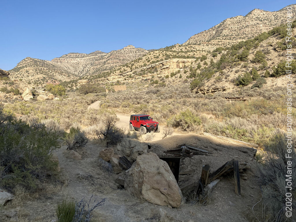
7 October 2020: Headed into the San Rafael desert, an area outside the circuit of “usual” Moab trails, to camp and explore more of this region. Set up a base camp for the next few days at a perfect spot nestled against a towering rock wall in a canyon near Temple Mountain where there would be some shade in both the morning and the late afternoon…
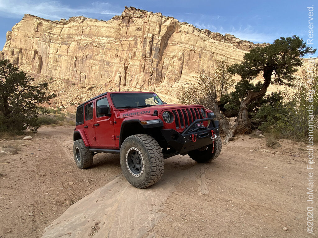
6 October 2020: Started the day with a loop around the Colorado National Monument’s Rimrock Drive, the first taste of Red Rock country for this trip, then headed west towards Moab. Made a detour for a leisurely visit to Sego Canyon which is home to a favorite rock art panel and a little ghost town tucked into the canyon beyond it…
5 October 2020: A quick look on the inciniweb showed that there were actually three fires surrounding the Vedauwoo area of the Medicine Bow-Routt National Forest (44 miles, 45 miles and 66 miles away in different directions) and also very close to the Araphao National Wildlife Refuge that was our next intended location. Plan B-ing and C-ing a new route to Grand Junction to visit a friend put us on Colorado Highway 139, or the “Pintado Canyon” route, which encompasses a number of rock art sites on BLM land before reaching Douglas pass at an elevation of 8,268 ft. where it then descends dramatically into the familiar “desert” landscape nearer to Grand Junction…
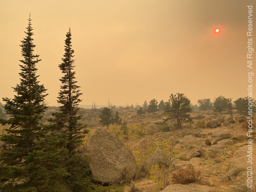
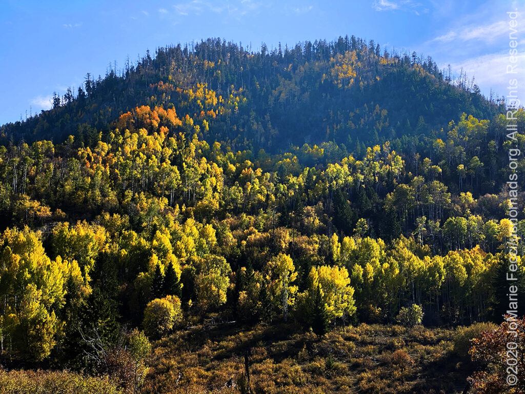
4 October 2020: Spent the morning wandering through the physical history of the USA’s westward expansion, beginning with the Scott’s Bluff location and continuing west to the site of Fort Laramie and then to the Oregon Trail ruts — the physical traces left in the sandstone of all the wagon wheels that crossed this section of the “road” westward. It was a bizarre artifact that reminded me of the Jeep trails in Moab and Sedona where the “road” is worn into the rock in just the same way (except the wagon wheel ruts are much “narrower” — it is somewhat disconcerting to realize how very small those “covered wagons” actually were considering they carried an entire family and all their worldly possessions for the months long journey across the backcountry. Gives us a lot to think about when we are talking about what we “need” for overland travel). From there we turned southward, towards Colorado and an area of Wyoming known as Vedauwoo, to camp for the night. As we made our way the sky suddenly took on a strange appearance, kind of like a duststorm, but without dust. Thinking it might be the effects of the smoke from distant California wildfires, we continued on. The “smokescreen” grew thicker approaching Vedauwoo, to the point where the sky took on a strange shade of yellow-beige that was somewhat apocalyptic and the smell of smoke became visceral. Eyes tearing and scratchy throat, on arrival was enough to say “no camping,” though the campground remained open with the caveat of “No Fires” (not even charcoal). …
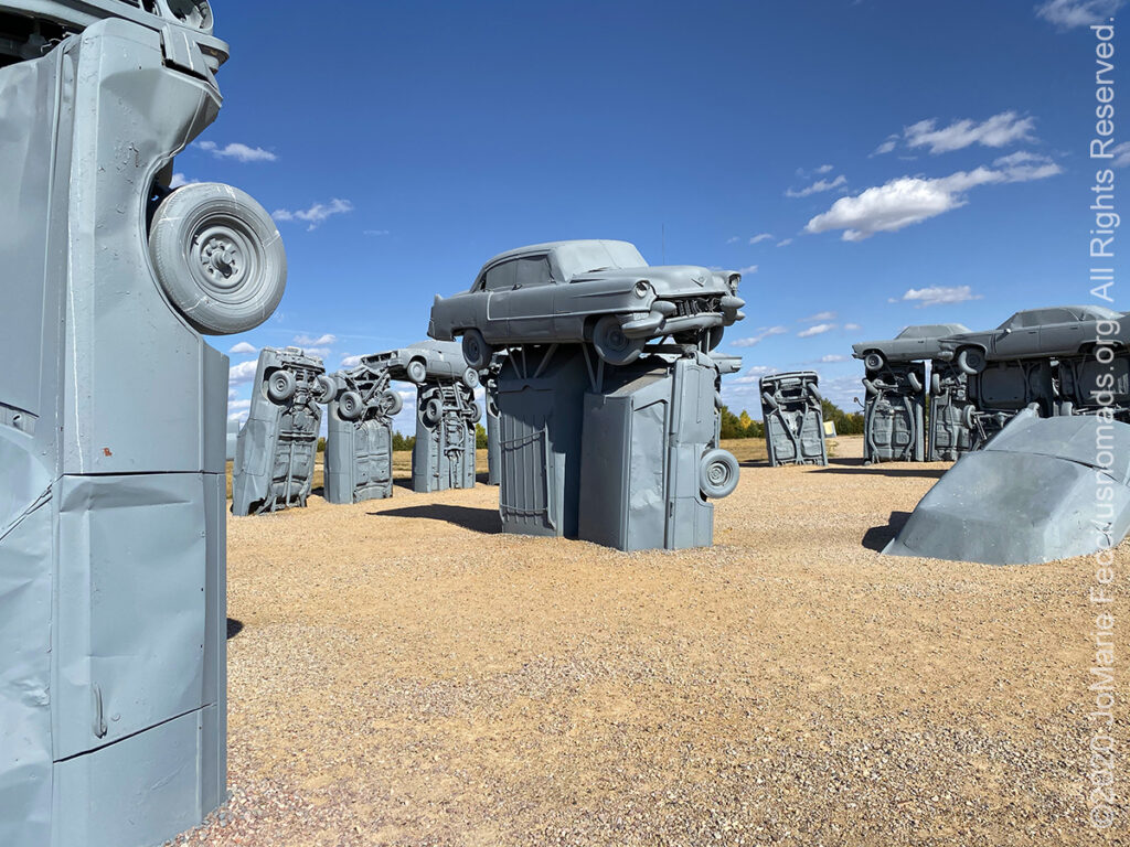
3 October 2020: Checked out some of the shared jeep and OHV trails as well as a few of the longer 4×4 forest roads in the morning and climbed the fire tower for a long view over the sandhills landscape before leaving the National Forest and continuing westward on Highway 2. The Halsey OHV area sits roughly at the point where the 100th Meridian marks the separation between “east” and “west” in terms of the landscape, and the western section of Highway 2 really did begin to look like “the west.” The afternoon was a peaceful drive on the lonely highway with plenty of photostops to try to capture the essence of the sandhills (where more than one local driver kindly stopped to make sure we were ok where we had pulled off the road). Eventually we meandered our way to the town of Alliance, home of the “Carhenge” art installation. It was late afternoon and the light was just right. From Alliance we continued to Scott’s Bluff, making a quick stop at the sight of the Chimney Rock formation that stood as a beacon to the western pioneer families making the long wagon train journey along the old Oregon Trail back in the 1800s. Chimney Rock and the Scott’s Bluff formations were the first topographical bits of “relief” travelers could see after crossing the flatness of the “Great Plains” and were a welcome symbol of the journey’s progress back then, and also for us now…
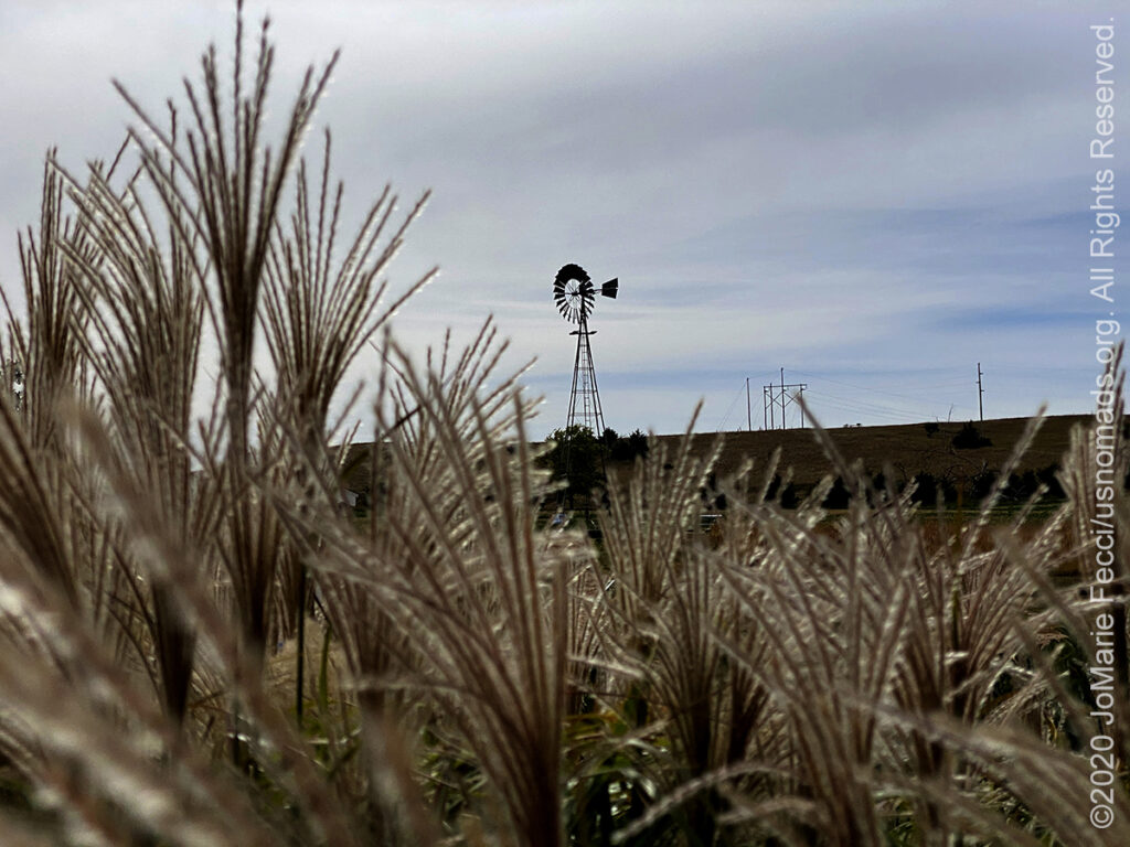
2 October 2020: Left Mormon Island and picked up Highway 2 heading north and west into the “sandhills” region, which initially transitioned from the flat lands into gently rolling hills covered with vegetation. Though one could see the “sand dune”-like pattern of topography, the green vegetation camoflauged the sand itself. Farms of wheat and corn fields morphed into cattle ranches, and the ubiquitous metal “windmills” of the old west began to appear, drawing water from deep underground for the livestock. Finished up the day setting up camp at the Halsey OHV area, where intermittent rainfall interrupted the evening BBQ, before clearing later that night …

1 October 2020: Crossed into Nebraska early in the morning and bee-lined for the Grand Island area where the “Sandhills Scenic Byway,” otherwise known as Nebraska Highway 2, begins. Took one sidetrip to a privately run wildlife reserve in Ashland to visit some prairie dogs before setting up camp for the night at Mormon Island State Recreation Area where we watched an incredibly beautiful moonrise …
THIS MONTH:

Hitting the road again to begin the next big U.S.A. Roadtrip to the west. For this journey we will be spending some time en route exploring a few of the wild places in between New York and Moab. We are making the long drive west into its own overland adventure with camping, hiking and off-road fun. The focus of this trip is to appreciate America’s wilderness and get to know some of the lesser known public lands along the way…
COMING UP SOON:
A new Moab adventure is in the works for October, details to come soon…

The 5th Annual 2020 Ladies Offroad Challenge started on May 4th. Ladies will participate in a series of challenge tasks that are built to educate and encourage stepping into some unknown territories. The Challenge goes on through October this year with participants striving to “Do the Best They Can” at each of the tasks. Ten Participants from the Challenge will be invited to the very special Top 10 Weekend hosted by Charlene Bower…

Looking ahead to a return to Paris as soon as possible to reconnect with friends and some favorite places in the city of light. Timing is still uncertain due to the pandemic, but we hope the trip is back on the calendar for late fall/early winter…
CHIMNEY ROCK
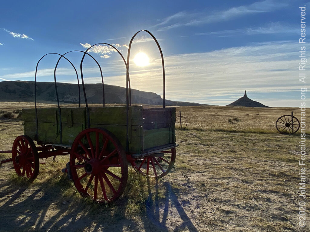
Chimney Rock is a prominent geological rock formation in western Nebraska. A slender spire rises 325 feet from a conical base above the surrounding North Platte River valley (the peak of Chimney Rock is 4,228 feet above sea level). The imposing formation, composed of layers of volcanic ash and brule clay dating back to the Oligocene Age (34 million to 23 million years ago). Designated the Chimney Rock National Historic Site in 1956, Chimney Rock is one of the most famous and recognizable landmarks for pioneer travelers on the Oregon, California, and Mormon Trails, a symbol of the great western migration. Located approximately four miles south of present-day Bayard, at the south edge of the North Platte River Valley, Chimney Rock is a natural geologic formation, a remnant of the erosion of the bluffs at the edge of the North Platte Valley. Prior to exploration and settlement by European immigrants, the Native Americans of the area—mainly the Lakota Sioux—would refer to this formation by a term which meant “elk penis”. The first non-natives to see the pillar were probably the Astorians of Robert Stuart in their eastward journey from the Pacific Ocean in 1813. Chimney Rock was recorded in many journals after the Stuart expedition. The name “Chimney Rock” probably originated from early fur traders. The first recorded mention of “Chimney Rock” was in 1827 by Joshua Pilcher. Pilcher had journeyed up the Platte River valley to the Salt Lake rendezvous of the Rocky Mountain fur trappers. The formation went through a variety of names before becoming Chimney Rock such as Chimley Rock and Chimney Tower, as well as euphemisms based on the original Native American name, such as Elk’s Peak and Elk Brick. After examining over 300 journal accounts of settlers moving west along the Platte River Road, historian Merrill Mattes concluded that Chimney Rock was by far the most mentioned landmark. Mattes notes that although no special events took place at the rock, it held center-stage in the minds of the overland trail travelers. For many, the geological marker was an optical illusion. Some claimed that Chimney Rock could be seen upwards of 30 miles away, and though one travelled toward the rock-spire, Chimney Rock always appeared to be off in the distance—unapproachable. Because of this optical effect, early travel accounts varied in their description of the rock. Some travelers believed that the rock spire may have been upwards of 30 feet higher than its current height, suggesting that wind, erosion, or a lightning strike had caused the top part of the spire to break off. Throughout the ages, the rock spire has continued to capture the imaginations and the romantic fascinations of travelers heading west. Based on sketches, paintings, written accounts, and the 1897 photograph by Darton, Chimney Rock was taller when it was first seen by settlers, but has since been reduced in height by erosion and lightning…
CARHENGE
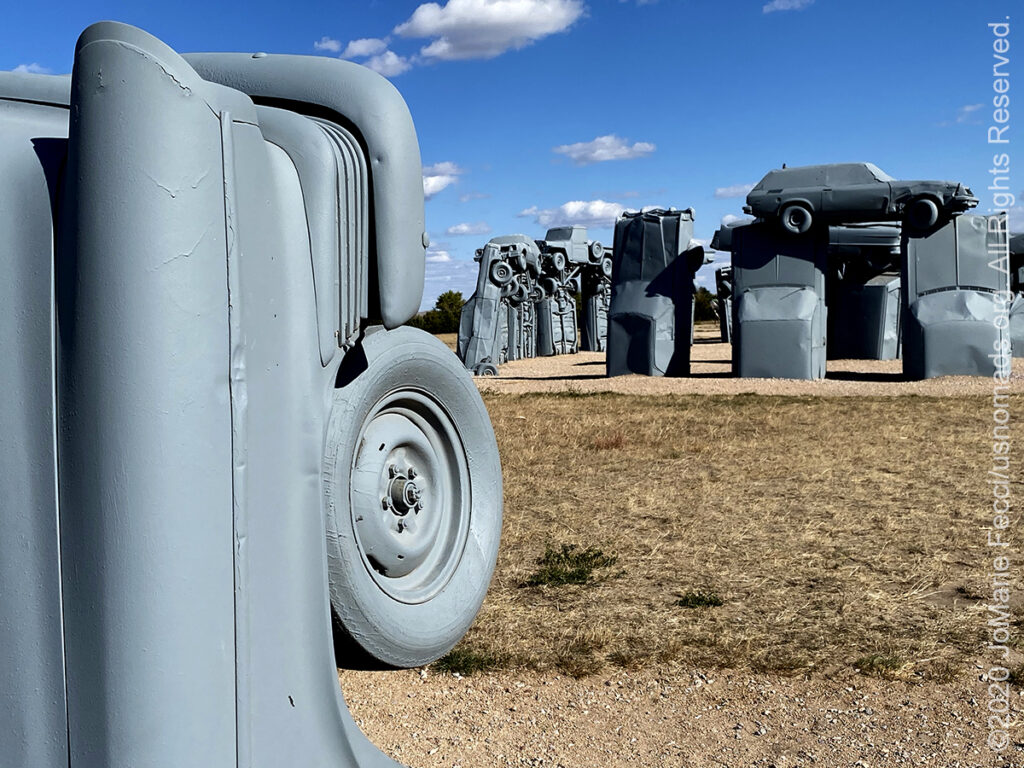
Carhenge is a replica of England’s Stonehenge located near the city of Alliance, Nebraska. Instead of being built with large standing stones, as is the case with the original Stonehenge, Carhenge is formed from vintage American automobiles, all covered with gray spray paint. Built by Jim Reinders, it was dedicated at the June 1987 summer solstice. The installation consists of 39 automobiles arranged in a circle measuring about 96 feet in diameter. Some are held upright in pits 5 feet eep, trunk end down, and arches have been formed by welding automobiles atop the supporting models. The heelstone is a 1962 Cadillac. Carhenge was conceived in 1987 by Reinders as a memorial to his father. While living in England, he studied the structure of Stonehenge, which helped him to copy the structures shape, proportions, and size. The path of totality of the solar eclipse of August 21, 2017 included Carhenge. An estimated 4,000 people, including Nebraska governor Pete Ricketts, viewed the eclipse from the site. Reinders stated that at the time of Carhenge’s creation, he had not known about the eclipse that would occur 30 years later. In addition to the Stonehenge replica, the Carhenge site includes several other artworks created from autos covered with various colors of spray paint…
NEBRASKA SANDHILLS
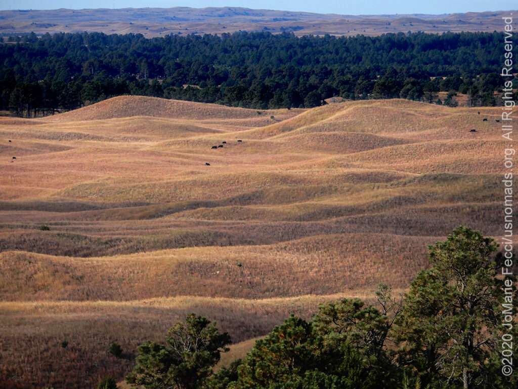
The Sandhills, often written Sand Hills, is a region of mixed-grass prairie on grass-stabilized sand dunes in north-central Nebraska, covering just over one quarter of the state. The dunes were designated a National Natural Landmark in 1984. Dunes in the Sandhills may exceed 330 feet in height. The average elevation of the region gradually increases from about 1,800 feet in the east to about 3,600 feet in the west. The Sandhills sit atop the massive Ogallala Aquifer; thus both temporary and permanent shallow lakes are common in low-lying valleys between the grass-stabilized dunes prevalent in the Sandhills. The eastern and central sections of the region are drained by tributaries of the Loup River and the Niobrara River, while the western section is largely composed of small interior drainage basins. The World Wide Fund for Nature (WWF) designated the Sandhills as an ecoregion, distinct from other grasslands of the Great Plains. According to their assessment, as much as 85% of the ecoregion is intact natural habitat, the highest level in the Great Plains. This is chiefly due to the lack of crop production: most of the Sandhills land has never been plowed. These plant-anchored dunes were long considered an irreclaimable desert, until cattlemen began to discover their potential as rangeland for Longhorn cattle in the 1870s. Today the Sandhills remain a productive cattle ranching area, supporting over 530,000 beef cattle…
Nesconset | Paris | Belgrade | Howard | Toledo | Silver Lake | Chesterton | Prairie City | Grand Island | Halsey | Gering | Buford | Hayden | Grand Junction | Moab

MORE NOTES FROM THE ROAD:
16-30 September – Roadtrip West
1-15 September – Long Island
16-31 August – Long Island
1-15 August – Summer Roadtrip
22-31 July – Summer Roadtrip
14-21 July – Summer Roadtrip
1-13 July – Long Island
16-30 June – Long Island
1-15 June – Bald Eagle
16-31 May – Central PA
1-15 May – Re-opening Trails
April – Lockdown NY
16-31 March – Lockdown NY
9-15 March – Roadtrip Home
1-8 March – Moab
23-29 February – Vegas to Anza Borrego
15-22 February – Southwest Roadtrip
8-14 February – Southwest Roadtrip
1-7 February – Glamis to Vegas
27-31 January – Yuma to Glamis
15-26 January – Nevada to Arizona
1-14 January – Starting the New Year
24-31 December – Holidays on the Road
16-23 December – Cross-Country Drive
9-15 December – New York
1-8 December – Paris
16-30 November – Paris & Rennes
1-15 November – New York
14-31 October – Arizona
8-13 October – LON TOP TEN
1-7 October – Girl Gang Garage
16-30 September – Women’s Wheeling
1-15 September – Long Island
Archive
EVENTS
LADIES OFFROAD NETWORK NONCON 2020
Recap from the Ladies Offroad Network camping and wheeling event, dubbed the “NonCon” as in “not the convention,” that came together after the official convention was cancelled due to the pandemic… [read]
RE-OPENING
Report from the first trail run with the Off Road Consulting group at Rausch Creek Off Road Park as the post-pandemic phased re-openings begin in Pennsylvania and some of our favorite local trails re-open to the public after the two-month shutdown… [read]
REFLECTIONS

EGYPT: CAIRO REFLECTIONS
A quick overview of impressions from a stop in Cairo during our recent scouting mission in Egypt and Sudan … [read]
SPECIAL REPORT

A look into south-eastern Algeria on the border with Libya and Niger: overlanding with the Tuareg in one of the most remote corners of the Sahara … [read]