
< more recent | 8-15 March 2021 | older >

15 March 2021: Left Death Valley this morning after a brief stop at Mesquite Flats Sand Dunes, taking Badwater Road down to Shoshone. The wind was really blowing outside and there were dust squalls en route, but eventually made it out of the desert and back to civlization. Tomorrow is the flight to New York …
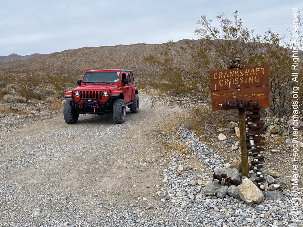
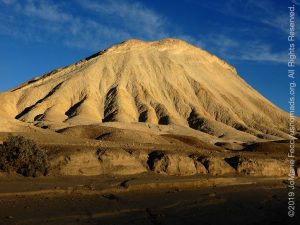
14 March 2021: The event wrapped up today, with a free day for exploring so headed for the Eureka Dunes via Crankshaft Junction …
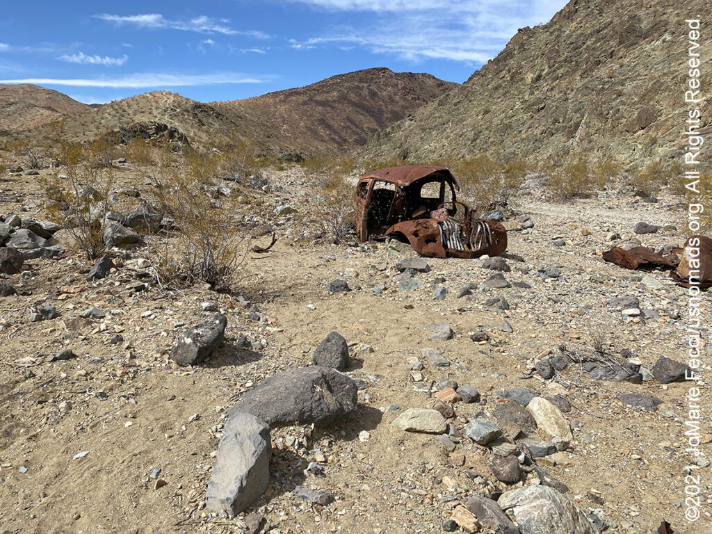
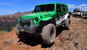
13 March 2021: Lead a small group of experienced wheelers on the Barker Ranch run, which is the longest route of the event. The group did a great job and made a real “team effort” to get one of the trucks up over the obstacle, reaching the old Manson compound only a little later than scheduled. The return route was slower going because of a group of motos ahead of us that included an inexprienced rider who was fatigued and kept dropping his bike. We helped as we could and followed them until they were past the main obstacle, where they were planning to camp nearby. The delay meant we didn’t exit the trail before dark, but on the up side we got to see a lot of burros in the late afternoon …
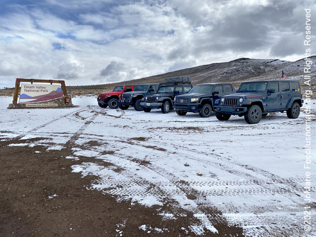
12 March 2021: Surprised by snow and cold weather on the trails today. We even posed for a “snow wheeling” photo in front of the park sign with snow on the ground and in the monutains behind. It was actually quite beautiful, though not the best climate for exploring on foot or walking around town. Once we started on the desert loop the snow seemed to disappear and our stops were a bit warmer. Lunch at the China Garden was comfortable enough and we got to see the Koi pond before finishing up the route to the Falls …

11 March 2021: With no guiding assignment today it was the perfect day to do some independent exploring, and the weather was bizarre making for some interesting photos of rain in the desert. Apparently it also snowed in some places, though Mesquite Springs camp was dry. Best part of the day was seeing and photographing a coyote on the way back to camp in the late afternoon …
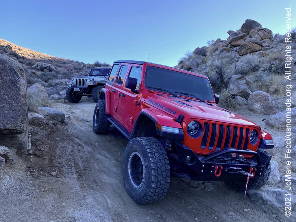
10 March 2021: The first day of the inaugural edition of the Death Valley Experience event went well. Our group was small and everyone was well equipped and experienced, making it easy to guide the run and get everyone over the “waterfall” obstacle. It was a great day out on the trail, though extremely windy again …
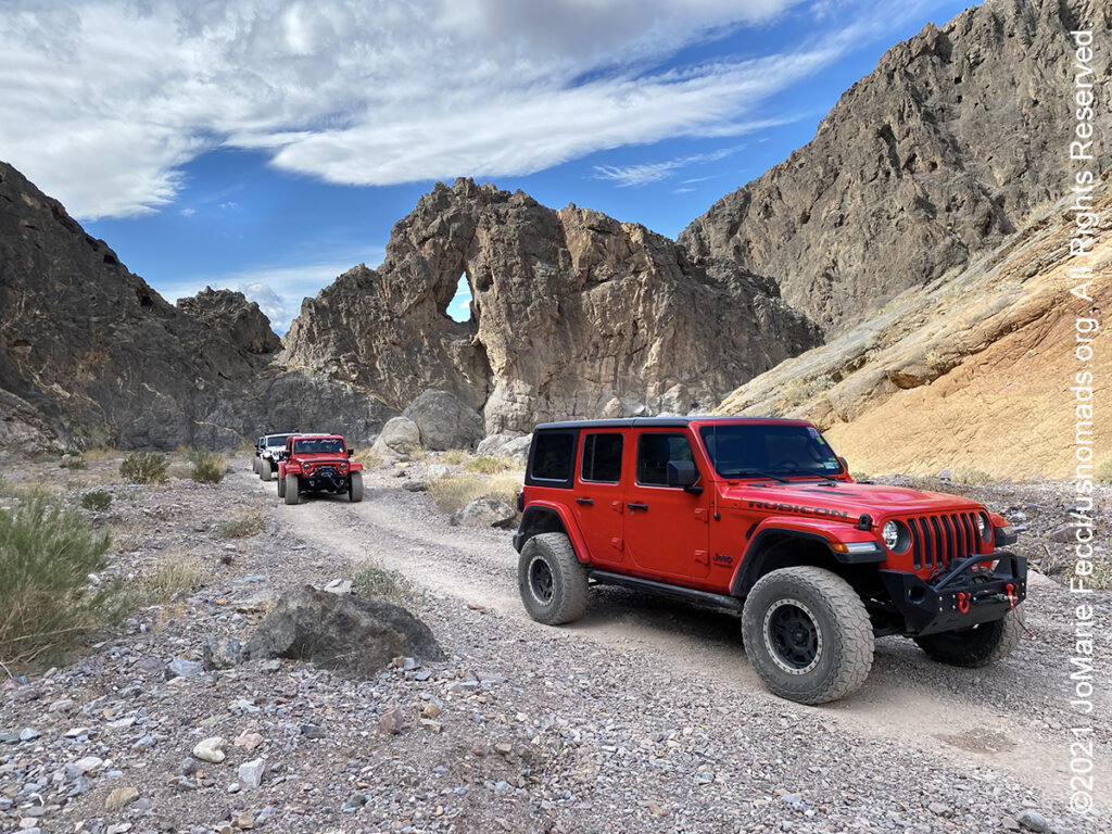
9 March 2021: Used today for a final scouting in preparation for the DVE event that starts tomorrow. Followed the trail itinerary in a loop behind the town of Darwin that leads through some active mining areas as well as some of the historical ruins, and scouted out some good places to stop with the group …

8 March 2021: Took the day to do a navigation simulation with a Rebelle Rally friend exploring the area beyond Echo Canyon in the Amargosa Valley with a brief stop at Rhyolite for sunset …
THIS MONTH:

Trail Guiding for the California 4-Wheel Drive Association’s inaugural Death Valley Experience 2021 fundraiser event running from March 10-14, 2021. Each day will feature a choice of runs to some famous, some infamous and some secretive points of interest within Death Valley National Park. The runs will depart from Furnace Creek and from Stovepipe Wells. Some of the points of interest we will visit during Death Valley Experience 2021 include Zabriskie Point (famous), Barker Ranch (infamous) and the Racetrack (learn the secret of the moving rocks). Other points of interest include Dante’s View, 20 Mule Team Canyon, Artists’ Drive, Chloride Cliffs, Aguereberry Point, Skidoo, Titus Canyon, and Darwin Falls. All of the trail runs are suitable for novice drivers and SUVs with high clearance and 4-wheel drive…
COMING UP SOON:
![]()
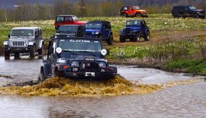
Joining in on a Ladies Offroad Network camping adventure in Arizona: Five days of fun learning out on the trail and in camp with Charlene Bower and a small group of adventure-minded ladies. The event consists of three core days of trail runs and training, and two days with additional optional activities designed around the event theme…

Every Day Is a Clean Up Day in 2021. Ladies Offroad Network has partnered with TreadLightly! to create a year-long program that encourages members to pick up trash on the trails whenever they are out off-roading. Participants simply pick up the trash, weigh it, take a photo, and log the location and time it took, then upload the details. At the end of the year there will be a series of prizes based on pounds of trash removed from the trails as well as participation in other TreadLightly! initiatives. This is a great way to do some good on a local level and make a larger impact via the national program…
DEATH VALLEY
Steady drought and record summer heat make Death Valley a land of extremes. Yet, each extreme has a striking contrast. Towering peaks are frosted with winter snow. Rare rainstorms bring vast fields of wildflowers. Lush oases harbor tiny fish and refuge for wildlife and humans. Despite its morbid name, a great diversity of life survives in Death Valley. Death Valley in the northern Mojave Desert, bordering the Great Basin Desert,t is one of the hottest places on Earth. Death Valley’s Badwater Basin is the point of lowest elevation in North America, at 282 feet below sea level, and it is 84.6 miles east-southeast of Mount Whitney, the highest point in the contiguous United States. On the afternoon of July 10, 1913, the United States Weather Bureau recorded a high temperature of 134 °F at Furnace Creek in Death Valley, which stands as the highest ambient air temperature ever recorded at the surface of the Earth. Death Valley runs from north to south between the Amargosa Range on the east and the Panamint Range on the west; the Grapevine Mountains and the Owlshead Mountains form its northern and southern boundaries, respectively. Death Valley is technically a “graben”-—a downdropped block of land between two mountain ranges. The valley is extremely dry, because it lies in the rain shadow of four major mountain ranges (including the Sierra Nevada and Panamint Range). Moisture moving inland from the Pacific Ocean must pass eastward over the mountains to reach Death Valley; as air masses are forced upward by each range, they cool and moisture condenses, to fall as rain or snow on the western slopes. When the air masses reach Death Valley, most of the moisture has already been lost and there is little left to fall as precipitation. …
NAMING DEATH VALLEY
Death Valley’s name is a legacy of the “Lost ’49-ers,” a group of prospectors on their way to the California Gold Rush that got stuck in this harsh desert environment. The group was part of the mass of fortune hunters making their way west after gold was discovered at Sutter’s Mill in California in 1848. One of the supply points along the trail was Salt Lake City, where pioneers prepared for the long journey across the Great Basin desert before climbing over the Sierra Nevada to the gold fields of California. It was important to leave Salt Lake City and cross the desert before snow began to fall on the Sierra Nevada, making them impassible. Only a couple of years before, a group of pioneers called the Donner Party was trapped by a storm, an event that became one of the greatest human disasters of that day and age. The fate of the Donner Party was fresh on everyone’s mind when a group of wagons began their journey from Salt Lake City in October of 1849 — much too late to try to cross the Sierra Nevada safely. The group had heard about “the Old Spanish Trail,” a route that went around the south end of the Sierra Nevada and was safe to travel in the winter. The problems were that no pioneer wagon trains had traversed it and they could only find one person in town who knew the route and would agree to lead them. The going was slower than most of the travelers wanted, but the group’s guide, Captain Jefferson Hunt, would only go as fast as the slowest wagon in the group. Just as the people were about to voice their dissent, a young man rode into camp and showed some of the people a hand-sketched map that showed a fictitous “short cut” across the desert to a place called Walker Pass. Everyone agreed that this would cut off 500 miles from their journey so most of the 107 wagons decided to follow this purported short cut while the other wagons continued along the Old Spanish Trail with Captain Hunt. Almost as soon as these people began their journey, they found themselves confronted with an obstacle, a gaping canyon on the present day Utah-Nevada state line. Most of the people became discouraged and turned back to join Captian Hunt, but more than 20 wagons decided to continue on. It was a tedious chore getting the wagons around the canyon and took several days. Despite the fact that the group didn’t have a reliable map, they decided to continue on thinking that all they had to do was go west and they would eventually find the pass. At Groom Lake they got into a dispute on which way to go. One group—-the Bennett-Arcan party—-wanted to head south toward the distant, snow-clad Mt. Charleston in hopes of finding a good water source. The other group—-the Jayhawkers—-wanted to stay with the original plan of traveling west. The group eventually split and went their separate ways. They entered the valley by way of present day Death Valley Junction and along the same route followed by Highway 190. The lost ’49ers had now been traveling across the desert for over two months. Their oxen were weak from lack of forage and their wagons were battered and in poor shape. They too were weary and discouraged but their worst problem was not the valley that lay before them. It was the towering Panamint Mountains that stood like an impenetrable wall as far as could be seen. From Furnace Creek, the routes of the two groups diverged. The Jayhawkers (including the Brier family) went north toward the Mesquite Flat Sand Dunes where they decided they would have to leave their wagons and belongings behind and walk. They slaughtered several oxen and used the wood of their wagons to cook the meat and make jerky. After crossing the Panamint Mountains via Towne Pass and dropping down into Panamint Valley, most of them turned south, making their way into Indian Wells Valley near the present day city of Ridgecrest. Meanwhile, the Bennett-Arcan party struggled across the salt flats and attempted to pass over the Panamint Range via Warm Springs Canyon, but were unable to do so. They retreated to the valley floor and sent two young men, William Lewis Manly and John Rogers, ‘over the mountain’ to get supplies, thinking the Panamint Range was the Sierra Nevada. When Manly and Rogers finally arrived back to the camp of the Bennett-Arcan party they found many of the group had left to find their own way out of the valley. As they finally made their way west over the mountains, one of the prospectors turned back to look at the valley below and proclaimed “Goodbye, Death Valley,” giving the valley its name …
Nesconset | Paris | Belgrade | Akron | St. Louis | Clinton | Grants | Yuma | Borrego Springs | Laughlin | Baker | Barstow | Ridgecrest | Lone Pine | Death Valley | Beatty | Sedona | Phoenix
MORE NOTES FROM THE ROAD:
1-7 March – Arizona
22-28 Februay – Alabama Hills
15-21 Februay – Mojave Road
8-14 Februay – Death Valley
1-7 Februay – Glamis
15-31 January – Roadtrip Southwest
1-14 January – Long Island
22-31 December – Holiday Roadtrip
15-21 December – Holiday Roadtrip
7-14 December – Holiday Roadtrip
1-6 December – Long Island
15-30 November – Long Island
1-14 November – Long Island
28-31 October – Roadtrip East
22-27 October – Moab
15-21 October – Moab
8-14 October – Moab
1-7 October – Roadtrip West
16-30 September – Roadtrip West
1-15 September – Long Island
16-31 August – Long Island
1-15 August – Summer Roadtrip
22-31 July – Summer Roadtrip
14-21 July – Summer Roadtrip
1-13 July – Long Island
16-30 June – Long Island
1-15 June – Bald Eagle
16-31 May – Central PA
1-15 May – Re-opening Trails
April – Lockdown NY
16-31 March – Lockdown NY
9-15 March – Roadtrip Home
1-8 March – Moab
Archive
EVENTS
LADIES OFFROAD NETWORK NONCON 2020
Recap from the Ladies Offroad Network camping and wheeling event, dubbed the “NonCon” as in “not the convention,” that came together after the official convention was cancelled due to the pandemic… [read]
RE-OPENING
Report from the first trail run with the Off Road Consulting group at Rausch Creek Off Road Park as the post-pandemic phased re-openings begin in Pennsylvania and some of our favorite local trails re-open to the public after the two-month shutdown… [read]
SPECIAL REPORT

A look into south-eastern Algeria on the border with Libya and Niger: overlanding with the Tuareg in one of the most remote corners of the Sahara … [read]