
< more recent | 15-21 December 2023 | older >
![]()
21 December 2023: Up early this morning for the Winter Solstice sunrise which was a little less than spectacular due to overcast skies, but still quite beautiful in it’s own way. After the sun came up it was time to leave the beaches and the coast and head inland towards the Ocala National Forest where I am setting up this year’s “Christmas Camp” at Hopkins Prairie. The weather is a bit unsettled with some serious rain in the forecast, but I am determined to make camp as comfortable as possible and to stay for the Christmas celebration, at a minimum. Knowing the threat of long periods of rain, I decided to bring an Easy-Up so that it would be possible to do things at camp even if there was non-stop rain. Organized my campsite and just took the late afternoon moments to relax and enjoy the beauty of the place as the sun had come out and was transforming everything to that golden color and a pair of Sand Hill Cranes were strolling around the edge of the hammock where the marsh begins. It was a beautiful “welcome” to the forest …
20 December 2023: Caught the sunrise this morning as a strong wind blew the beach sand with force so great you could see it visually moving in fast flowing streams of dust suspended in the air just above the surface. The sunrise was beautiful but diffused by the clouds and the weather seemed unsettled. I had to go early to the Fort Matanzas National Monument Visitor Center to reserve a spot on the ferry to the actual historic fort (the ferry is run by NPS and is free, but there are no advance reservations, you must present yourself in person the same day, and spots are first-come-first-serve). The only way to get to the fort is with the ranger guided ferry visit and I signed up for one in the afternoon, then went out to explore some walking trails along the Matanzas River before checking out the fort itself…
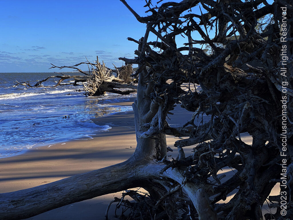
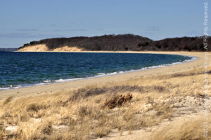
19 December 2023: I decided to turn my attention north today, following the coastal road back up towards Jacksonville to explore some areas I had missed on my way to St. Augustine due to the storm that drove me inland. I headed for Florida’s “Sea Islands“, the southern most part of the “Low Country” not far from Jacksonville. I found “Boneyard Beach” on Little Talbot Island — a section of the Little Talbot Island State Park where sun-bleached roots and fallen trunks of cedar and palm trees left to erode on a strip of beach create a linear tapestry of natural sculptures. Little Talbot Island is one of only a handful of undeveloped barrier islands remaining in Northeast Florida and a great place to experience the timelessness of this ecosystem. Access to the “boneyard” is by a short walking trail through the maritime forest and it is important to be aware of the tides, because the tree trunks and roots are on a very narrow section of sandy beach that can be cut off at high tide. I felt a sense of urgency as I photographed because it seemed as if the tide was coming in as I was walking among the ghost trees and I was concerned if I went too far down the beach I might get trapped by the incoming tide. After leaving Little Talbot Island I turned back towards Vilano Beach and made it to Porpoise Point in time to catch a gorgeous sunset…
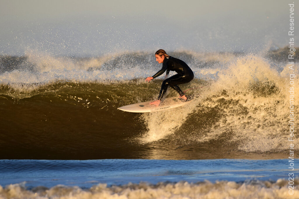
18 December 2023: The sun came out today, but the winds were still strong and the Atlantic was restless. I decided to explore the coast to the south of St. Augustine, and took the A1A towards Flagler Beach, stopping at various points along the way. Once past the area of Anastasia Island State Park, there are a series of different access points to beaches and different types of protected public land units which keeps the area accessible and also lends it a sense of wilderness, with tracts of dunes and maritime forest. The first stop of the day was at the 90-acre River to Sea Preserve, which protects a rapidly disappearing maritime scrub environment. It begins at the beach of the Atlantic Ocean near Marineland and reaches west to the Matanzas River, with walking trails though the oak scrub and hardwood hammock and public access to the beach where there are outcroppings of the unique coquina rocks that were used to build the Castillo St. Marcos and many other structures here. A little further south the Washington Oaks Garden State Park protects another tract of land with a picturesque oak hammock on the river side and a unique shoreline of coquina rock formations along the Atlantic beach. In the afternoon I backtracked, stopping at the Fort Matanzas National Monument to explore another section of beach and the waves were crashing ashore with force. Just before sunset a few surfers arrived to the deserted beach and hurried out to take advantage of the waves …
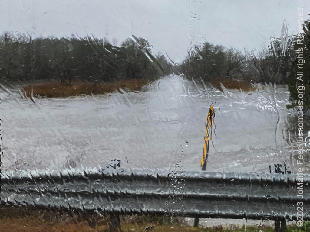
17 December 2023: Good thing I went to visit the Angel Oak yesterday as the storm started in the evening and is continuing today and there is some serious flooding and dangerous conditions around the Low Country and these Sea Islands. I decided to alter my plan and take an inland route south that would be safer, but I had to wait until a major Flood Warning for my immediate area expired around noon. It was strange and a bit scary driving through this storm and seeing the water levels approaching the roads. At some point the water was less than three feet from the road, and still raining heavily. I drove prudently but quickly and without stopping until I was out of the danger area. Eventually I made it to the Interstate, and just took I-95 all the rest of the way to Florida, arriving to Vilano Beach in the night…
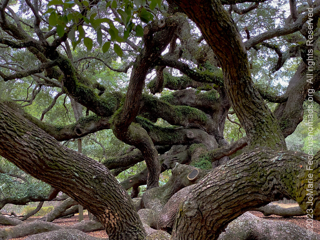
16 December 2023: The weather has started to turn, and a storm is threatening, but I managed to make a few stops on my planned route today as I drove along the coastal route south from North Carolina into South Carolina. I paused to take some time to explore around the Cape Romain National Wildlife Refuge, where I had learned they had a Red Wolf program at the Sewee Visitor & Environmental Education Center. After a Ranger talk on the Red Wolves, I went to look for the traces of a rice plantation in the I’om swamp, where pretty much everything had been reclaimed by the swamp, but the clear evidence of the rice fields were the series of straight “canals” that they used to irrigate the fields. These channels cut into the swamp remain, though now overgrown with vegetation and wilderness. It is hard to imagine that there could have been a working plantation and agricultural activity in what is now a wooded swamp covered with brush and forest. While there I was really lucky to see a pair of river otters in a section of one of the canals, and I was able to make a few photos before getting back on the road towards Charleston. With the weather threatening to force a change in plans for tomorrow, I decided to go to the Angel Oak before stopping for the night. I absolutely wanted to see this ancient tree and sort of make a kind of spiritual pilgrimage to the site …
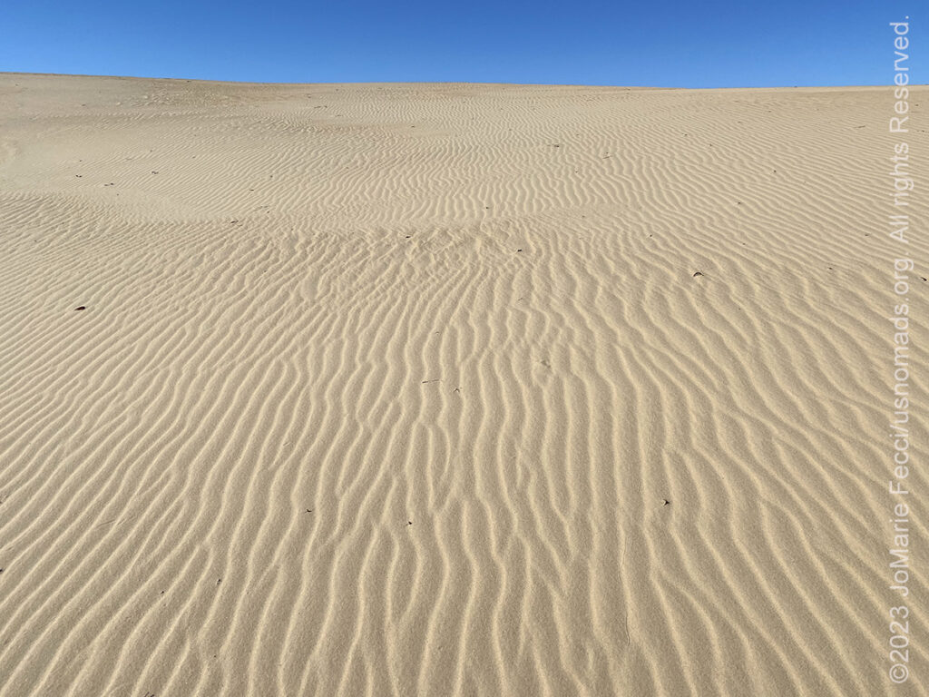
15 December 2023: Getting back on the road today, but lingered a bit around OBX just really enjoying the special ambiance of the barrier islands. As I made my way back towards the mainland I detoured to take a short hike into the big dunes at Jockey’s Ridge State Park, where the landscape looks like the desert, and though there was a slight wind, I walked up onto one of the larger dunes, just enjoying the solitude and the special feeling of the place. Left OBX in the afternoon and made my way down towards the Low Country where I am looking for traces of history again — in this case the story of the Gullah-Geechee people, and their “story” seems to start around Wilmington NC where the barrier islands become known as the “Sea Islands” and they were the locations of the enormous rice plantations in remote and very harsh environments …
THIS MONTH:

Time for the annual Holiday Roadtrip. Getting ready to celebrate the Christmas holiday somewhere warmer and out in nature — will be setting up Christmas camp and enjoying exploring in the southeast this year. Focus on the Atlantic coastal areas as we head south and back to the Ocala National Forest…
COMING UP SOON:
Getting back to a favorite city to spend some time with friends and reconnect to the international community after what seems like a “too long” absence…
![]()
Joining the crew from Barlow Adventures as they present an intensive sand dune training at the Imperial Sand Dunes in southern California. This is a seven-day driving and navigation program that focuses on moving safely and effectively through large dunefields with skills-building exercises intended to improve pace, line choice and vehicle control. There is a full classroom day of navigation instruction focused on mapping and understanding the basics of plotting and route planning on paper maps, as well as increasingly challenging in-the-field practice to develop precision map and compass navigation skills. It all culminates in a final day of “chasing checkpoints” out in the big dunes…
![]()
Trail Guiding for the California 4-Wheel Drive Association’s fourth annual Death Valley Experience fundraiser event running in March. Each day will feature a choice of runs to some famous, some infamous and some secretive points of interest within Death Valley National Park. Some of the points of interest we may visit during Death Valley Experience 2024 include Zabriskie Point (famous), Barker Ranch (infamous) and the Racetrack (learn the secret of the moving rocks). Other points of interest include Dante’s View, 20 Mule Team Canyon, Artists’ Drive, Chloride Cliffs, Aguereberry Point, Skidoo, Titus Canyon, and Darwin Falls. All of the trail runs are suitable for novice drivers and SUVs with high clearance and 4-wheel drive…
![]()
USnomads.org is very proud to be presenting the third edition of the Nomad Overland Virtual Adventure Rally in 2024. This is a unique kind of rally experience — a ten week event that participants can do from anywhere within the continental U.S.A. Competitors design their own routes as part of the rally, then drive it in a points-based online competition that includes optional activity tasks, quests and weekly challenges. The 2024 rally will run from 3 June – 11 August and is open to any driver within the United States who has an off-road capable vehicle — stock or modified. Registration for 2024 is currently open. For more information see the Rally website …
FORT MATANZAS
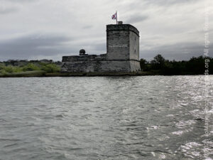
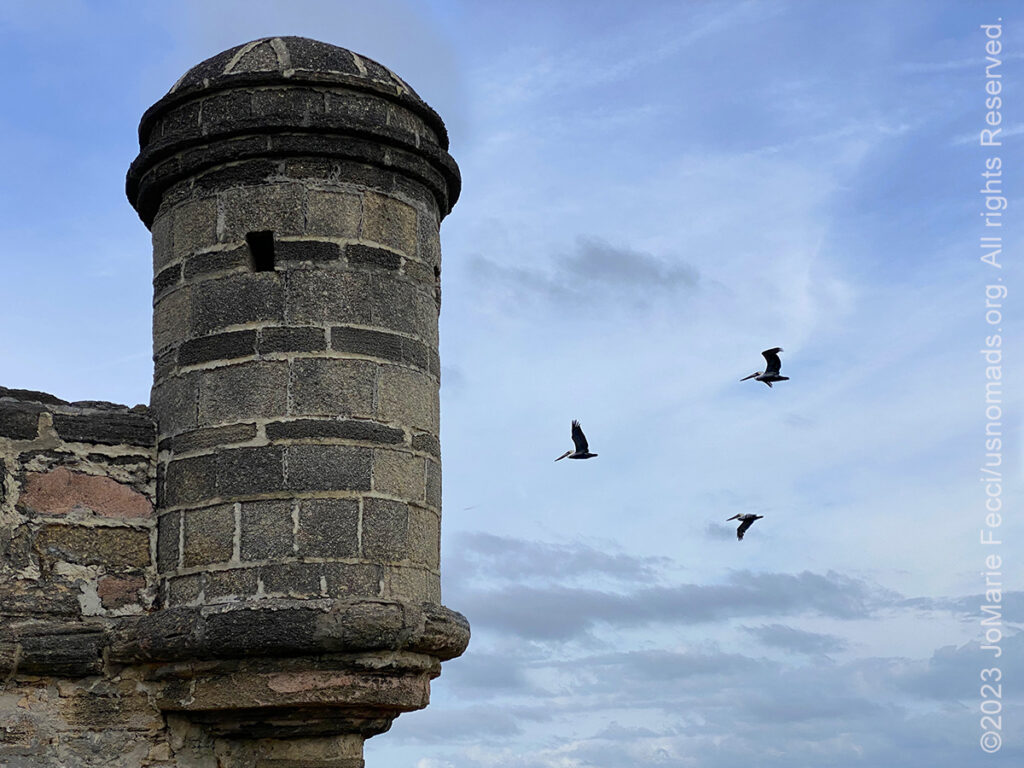
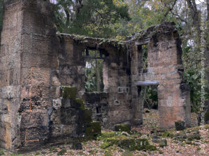
Fort Matanzas National Monument consists of the historical Spanish fort and about 100 acres of salt marsh and barrier islands along the Matanzas River on the northern Atlantic coast of Florida. Fort Matanzas was built in 1742 to guard Matanzas Inlet, the southern mouth of the Matanzas River, which could be used as a rear entrance to the city of St. Augustine. Such an approach avoided St. Augustine’s primary defense system, centered at Castillo de San Marcos. Engineer Pedro Ruiz de Olano, who had worked on additions to the Castillo de San Marcos, designed the fortified observation tower and convicts, slaves, and troops from Cuba were used as labor to erect the structure, which was sited on present-day Rattlesnake Island and had a commanding position over Matanzas Inlet. The standard garrison of the fort was one officer in charge, four infantrymen, and two gunners, though more troops could be stationed if necessary. In 1742, as the fort was nearing completion, the British approached the inlet with twelve ships. Cannon fire drove off the scouting boats, and the warships left without engaging the fort. This brief encounter was the only time Fort Matanzas fired on an enemy. Fort Matanzas was named for the inlet where a group of French colonists from Fort Caroline were executed by the Spanish in 1565 (“matanzas” means “massacres” in Spanish) …
ABOUT COQUINA
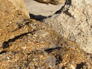
Coquina is a rare form of limestone derived from the ocean. Over time shell fragments of ancient mollusks and other marine invertebrates are glued together by dissolved calcium carbonate in the shells creating a kind of natural concrete (the term coquina comes from the Spanish word for “shellfish”). The Castillo de San Marcos in St. Augustine is the oldest (circa 1695) and largest masonry fort in the continental United States, and its masonry, or stonework, is largely comprised of coquina. Coquina can vary in hardness from poorly to moderately cemented. As a building material, it is lightweight, easy to find (it’s indigenous to the Florida coast), easy to use, and nearly indestructible. Not only is coquina bullet-proof, it is virtually cannon-ball-proof! Due to its plentiful microscopic air pockets, coquina is easily compressed. In days long past, cannon balls fired at the Castillo San Marcos simply lodged in its walls. Which, one supposes, is why the old fort still stands after 300 years. One of the best places to see coquina in its natural state is Washington Oaks Garden State Park about 30 miles south of St. Augustine. The park’s picturesque coquina outcroppings are some of the largest on the Atlantic Coast…
THE SEA ISLANDS & GULLAH-GEECHEE HISTORY
The Sea Islands are a chain of tidal and barrier islands on the Atlantic Ocean coast of the Southeastern United States. Numbering over 100, they are located between the mouths of the Santee and St. Johns rivers along the coast of South Carolina, Georgia, and Florida. The largest of these is Johns Island in South Carolina. Settled by indigenous cultures thousands of years ago, the islands were selected by Spanish colonists as sites for founding of colonial missions. Historically the Spanish influenced the Guale and Mocama chiefdoms by establishing Christian missions in their major settlements, from St. Catherine’s Island south to Fort George Island (at present-day Jacksonville, Florida). The area was home to multiple plantations, and by the middle of the 18th century, thousands of acres in the Georgia and South Carolina Lowcountry, and the Sea Islands were developed as African rice fields. African farmers from the “Rice Coast” brought the skills for cultivation and tidal irrigation that made rice farming one of the most successful industries in early America. Mosquitoes in the swamps and inundated rice fields of the Lowcountry picked up and spread the diseases to European settlers, as well. Malaria and yellow fever soon became endemic in the region. Because they had acquired some immunity in their homeland, Africans were more resistant to these tropical fevers than were the Europeans. As the rice industry was developed, planters continued to import enslaved Africans. By about 1708, South Carolina had a black majority. Coastal Georgia developed a black majority after rice cultivation expanded there in the mid-18th century. Malaria and yellow fever became endemic. Fearing these diseases, many white planters and their families left the Lowcountry during the rainy spring and summer months when fevers ran rampant. Others lived mostly in cities such as Charleston rather than on the isolated plantations, especially those on the Sea Islands. The planters left their European or African “rice drivers”, or overseers, in charge of the rice plantations. These had hundreds of laborers, with African traditions reinforced by new imports from the same regions. Over time, the Gullah people developed a creole culture in which elements of African languages, cultures, and community life were preserved to a high degree. Their culture developed in a distinct way, different from that of the enslaved African Americans in states such as North Carolina, Virginia, and Maryland, where the enslaved lived in smaller groups, and had more sustained and frequent interactions with whites and British American culture. Historically, the Gullah region extended from the Cape Fear area on North Carolina’s coast south to the vicinity of Jacksonville on Florida’s coast. Today the Sea Islands and “Low Country” are part of the Gullah-Geechee Cultural Heritage Corridor which focuses on the preservation and interpretation of historic sites in the Low Country relating to Gullah culture.
Nesconset | Paris | Belgrade | Cape May | Lewes | Berlin | Corolla | Awendaw | Ravenel | St. Augustine | Fort McCoy | Jacksonville

MORE NOTES FROM THE ROAD:
1-14 December – Holiday Roadtrip
8-30 November – New Jersey
1-7 November – Cape Cod
27-31 October – Cape Cod
16-26 October – Long Island
1-15 October – Roadtrip East
23-30 September – Roadtrip East
16-22 September – Colorado
8-15 September – Moab LONCON
1-7 September – Roadtrip West
August – Long Island
July – Roadtrip North
June – Nomad Rally Start
23-31 May – Nomad Prep
16-22 May – Nomad Prep
8-15 May – Long Island
1-7 May – Long Island
16-30 April – East Coast
8-15 April – Long Island
1-7 April – Roadtrip Home
1-7 April – Roadtrip Home
22-31 March – DVE
15-21 March – Arizona
8-14 March – Joshua Tree
1-7 March – Glamis
20-28 February – Southwest Roadtrip
1-19 February – Woman and Machine
January – Woman and Machine
22-31 December – Holiday Roadtrip
16-21 December – Holiday Roadtrip
1-15 December – Long Island
Archive
ROADTRIP

An epic journey crisscrossing the USA from east to west and back again, exploring some of the beautiful wild spaces that make up our “public lands.” The roadtrip covered almost 15,000 miles, much of it off-grid and off-pavement, focusing on the deserts of the American southwest. Some locations were truly “iconic” while others were little known, and the segments of independent exploration where punctuated with some fun events across the region… [read]
SPECIAL REPORT
All about exploring ghost towns and abandoned places in the USA and beyond, with tips, and information on the many different types of sites to be found across the globe, including detailed guides for eight specific sites… [read]
REFLECTIONS

EGYPT: CAIRO REFLECTIONS
A quick overview of impressions from a stop in Cairo during our recent scouting mission in Egypt and Sudan … [read]
SPECIAL REPORT

A look into south-eastern Algeria on the border with Libya and Niger: overlanding with the Tuareg in one of the most remote corners of the Sahara … [read]
LOCATION
This installment of a series that focuses on locations around the USA takes a look at some favorite places near our home base in NY. We share a few places we like to explore, where you can experience something of the raw natural beauty of coastal beaches, pine barrens and a little bit of obscure military history… [read]