
< more recent | 1-14 December 2023 | older >
14 December 2023: Took some time for exploring around the island with emphasis on the beach drive and the dunes in the wildlife refuge area where I got to see a couple more of the Bankers during my drive, but also took the time to examine more of the details that makes this drive unique. The island itself is very narrow at points, and later in the afternoon I did a hike through the maritime forest ecosystem that essentially took me from just behind the beach dunes to the marsh landscape on the Sound side and it was a nice easy walk. The sunset on the Sound was truly magnificient …
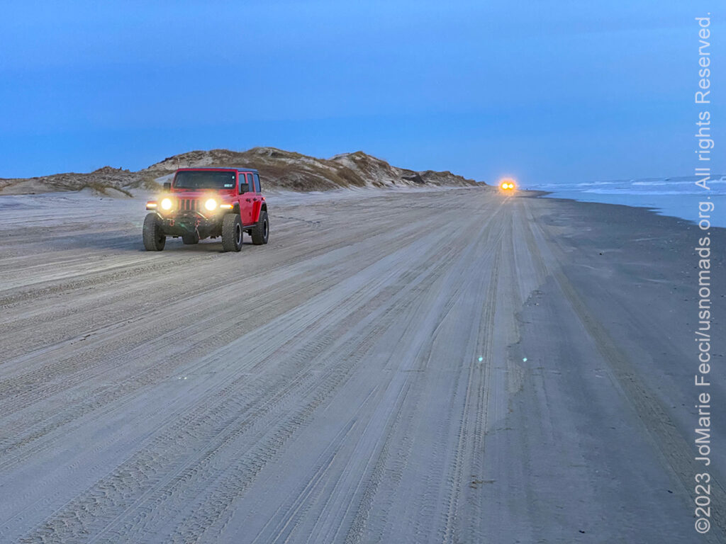
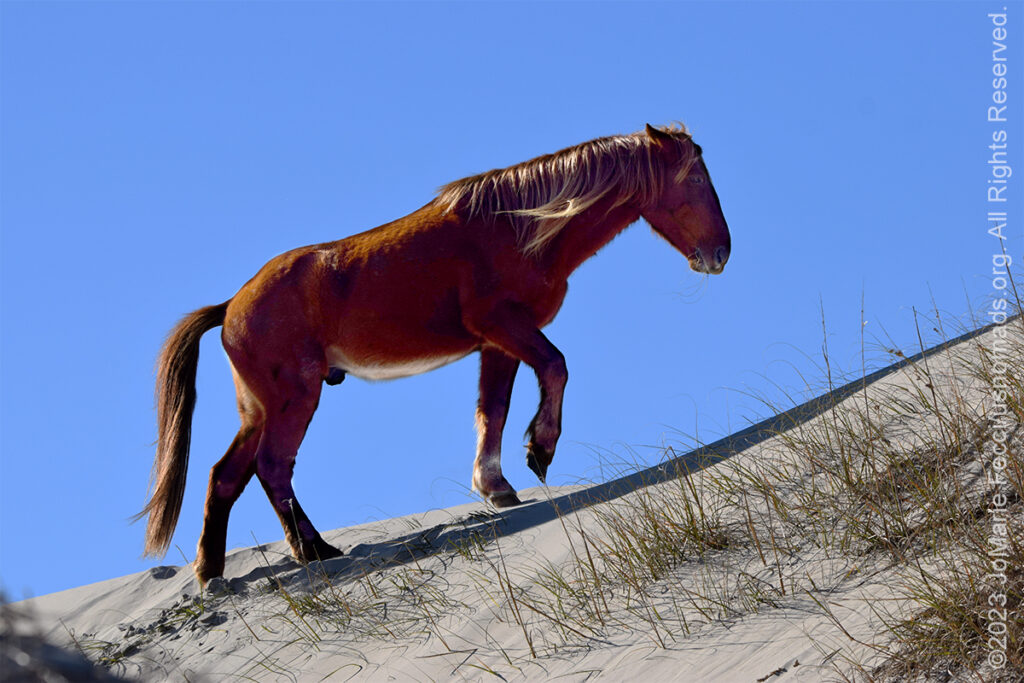
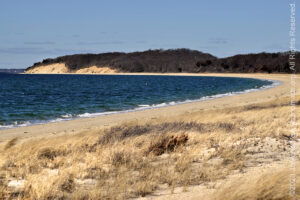
13 December 2023: Paused for a few days on the Outer Banks in North Carolina and chose the town of Carolla on the northern most “bank” that boundaries the Currituck Sound. The area is famous for its very own herd of wild horses the Currituck Bankers, which are a different breed than the Chincoteague Ponies, and have a story all their own. I hoped to have a chance to encounter some of these horses which roam the island beyond where the pavement ends. First thing in the morning I set out to find the 4×4 Jeep road along the beach, and I turned onto the sand as dawn broke. The wild beach was incredibly beautiful and other worldly with the blue light reflecting on the Atlantic and tinting everything an interesting shade of pastel. I drove a bit down the beach where I got distracted by a wonderful dune field that seemed to come alive in the early morning hours. I was surprised by how much vehicle “traffic” was out on the beach before sunrise. I returned later on in the day to go look for the horses and drove all the way up the beach to Carova without seeing any. I imagined that you must need to know where to look and turned back down the beach, just glad to be experiencing the freedom of such a wild beach environment. As I was about halfway back to Carolla I stopped to photograph in the dunes where I saw some animal tracks (which turned out to be FOX tracks!) and as I was following them, I saw they crossed what could only be horse tracks. I was surprised that horses would traverse sand dunes. As I continued the drive to Carolla, I noticed some movement on the dunes in my peripheral vision, and paused to look more closely and it was “them”. First I saw one horse, then another. They were just grazing on dune grass. I stopped and exited the Jeep and made some photos with the long lens and I was thrilled to have “found” them …
12 December 2023: Another big drive day today, from the Delmarva Peninsula to the Outer Banks. Always enjoy taking the Chesapeake Bay Bridge Tunnel at the tip of the Delmarva Peninsula across the bay and into Norfolk. It feels like you are driving on the water itself at certain points. Today the sky was clear and I could see commercial ships distant in the bay, seemingly all lined up for something. Once back on the “mainland” the route swung inland for a bit along HWY 168 heading south, then back towards the coast after crossing the VA-NC border. Crossed the Currituck Sound at Point Harbor to get onto the “Outer Banks” and continued on to the town of Corolla where I have a couple of days to explore…
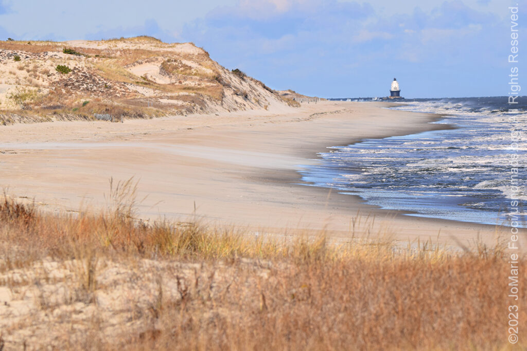
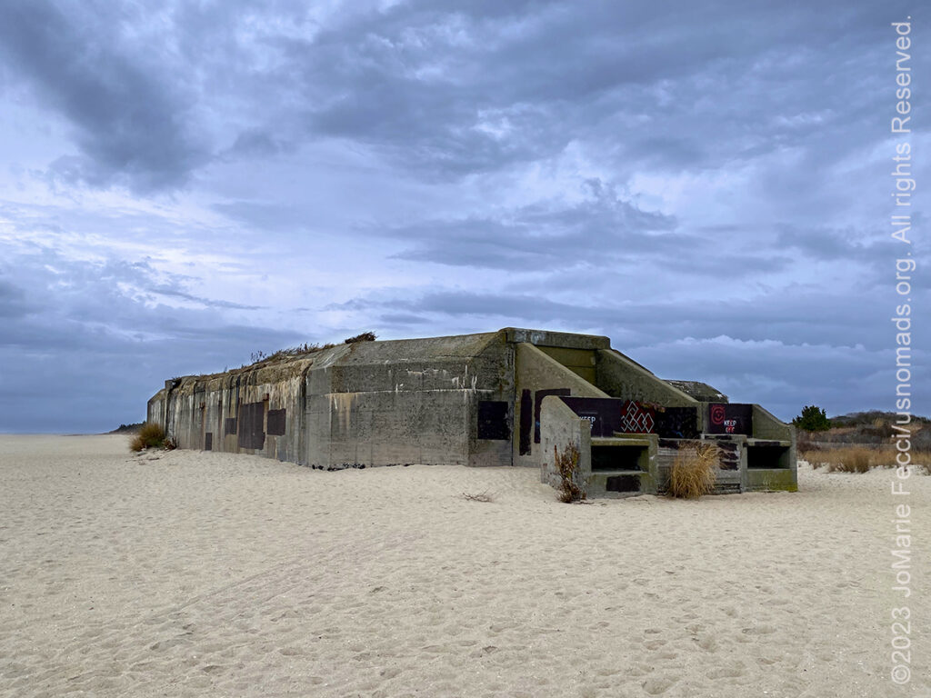
11 December 2023: The rain continued into the early morning when the sun peeked out and blue skies appeared for awhile, but it was very windy with 20mph winds as we headed to Prime Hook NWR on the Delaware Bay. Prime Hook protects the wetlands of the bay coastal area and part of the “Atlantic Flyway.” It was busy with flocks of geese flying in formation and did some photos around the marshes as well as making a stop at Slaughter Beach to see the “beach” habitat. From there continued on back to Cape Henlopen State Park to follow up on the military history and look for another old bunker, Battery Herring, which was right up on a great spot for observing the beaches and coastal dunes — could see all the way to the lighthouse! Spent some time exploring and photographing around the park, focusing mostly on Fort Miles history. The wind was making the ocean choppy and got some nice photos of that before heading to “The Point” which is the “tip” of Cape Henlopen where the beach dunes get really high and beautiful. It was incredibly windy there and I only stayed for a short bit before deciding to move on. Left the Lewes area following the coastal barrier islands with a brief stop on Fenwick Island to explore some more dunes. The skies had become overcast again and the wind seemed harsher. It was late in the afternoon and time to decide whether or not to attempt to make it to Assateague Island National Seashore to catch a sunset. With the interplay between the sun and the clouds it might be very beautiful there. Normally Assateague was on the “schedule” for tomorrow morning, but made the “executive decision” to change the plan and headed there today instead. Arrived with a bit of time to spare, so went looking for the ponies and found a few grazing around the marshes on the “Life of the Forest” trail. That trail has a cool boardwalk with overlooks on the marsh landscape, and that served as a great spot to safely photograph the ponies from quite close. There were about eight of them scattered around grazing and sloshing through the wet marsh. No great action, but did get some nice shots as the light on the marsh started getting interesting. Soon it was nearing sunset and while driving around looking for a good spot to shoot it, saw something in my peripheral vision walking along side the trail. Did a double-take and realized it was a red fox! I grabbed the big camera and snapped off a few frames before the fox disappeared into the underbrush. Then it was time for sunset which was just as amazing as I had expected it might be. After it was finished I picked up the road south continuing into Virginia before stopping at Exmore VA for the night…
10 December 2023: Started the annual Holiday Roadtrip in the wee hours of the morning today. Watched the sun come up while driving somewhere in NJ and arrived in good time to Cape May NJ where the Ferry to Delaware departs from. Was early so had some time to explore around Cape May and discover a lot of cool history, including an abandoned WWII bunker on the beach and some shipwrecks (old and new), before the weather turned stormy. The ferry crossing with rain and high winds was a bit “rocky” and the captain told everyone to sit down and not move about the boat, so didn’t get many photos of that segment of the journey — though I did manage to snap a few of the Delaware lighthouses once we were almost to harbor. No sunset, but did make a quick recon of Cape Henlopen State Park and found the Fort Miles site with some artillery pieces out in the woods…
THIS MONTH:

Time for the annual Holiday Roadtrip. Getting ready to celebrate the Christmas holiday somewhere warmer and out in nature — will be setting up Christmas camp and enjoying exploring in the southeast this year. Focus on the Atlantic coastal areas as we head south and back to the Ocala National Forest…
COMING UP SOON:

Getting back to a favorite city to spend some time with friends and reconnect to the international community after what seems like a “too long” absence…
![]()
Joining the crew from Barlow Adventures as they present an intensive sand dune training at the Imperial Sand Dunes in southern California. This is a seven-day driving and navigation program that focuses on moving safely and effectively through large dunefields with skills-building exercises intended to improve pace, line choice and vehicle control. There is a full classroom day of navigation instruction focused on mapping and understanding the basics of plotting and route planning on paper maps, as well as increasingly challenging in-the-field practice to develop precision map and compass navigation skills. It all culminates in a final day of “chasing checkpoints” out in the big dunes…
![]()
Trail Guiding for the California 4-Wheel Drive Association’s fourth annual Death Valley Experience fundraiser event running in March. Each day will feature a choice of runs to some famous, some infamous and some secretive points of interest within Death Valley National Park. Some of the points of interest we may visit during Death Valley Experience 2024 include Zabriskie Point (famous), Barker Ranch (infamous) and the Racetrack (learn the secret of the moving rocks). Other points of interest include Dante’s View, 20 Mule Team Canyon, Artists’ Drive, Chloride Cliffs, Aguereberry Point, Skidoo, Titus Canyon, and Darwin Falls. All of the trail runs are suitable for novice drivers and SUVs with high clearance and 4-wheel drive…
![]()
USnomads.org is very proud to be presenting the third edition of the Nomad Overland Virtual Adventure Rally in 2024. This is a unique kind of rally experience — a ten week event that participants can do from anywhere within the continental U.S.A. Competitors design their own routes as part of the rally, then drive it in a points-based online competition that includes optional activity tasks, quests and weekly challenges. The 2024 rally will run from 3 June – 11 August and is open to any driver within the United States who has an off-road capable vehicle — stock or modified. Registration for 2024 is currently open. For more information see the Rally website …
ASSATEAGUE ISLAND
The Assateague Island National Seashore, managed by the National Park Service, stretches for 37 miles along the Atlantic coasts of Maryland and Virginia and is part of a vast chain of barrier islands extending from Maine to Texas. Barrier islands form when offshore sand deposits accumulate sufficiently to break the water surface or when sea level rise causes inland dunes to become separated from the mainland. These islands are highly dynamic constantly reshaped by storms and currents that transport sand south along the coast throughout the year. On a seasonal basis, harsh winter weather pulls sand from dunes and upper beaches, depositing it into offshore sand bars and reducing beach width. This process is reversed during milder summer weather, as gentler wave action acts to restore the shoreline. Assateague is also moving westward as a result of sea-level rise and the force of the surf through a process called “island rollover.” During severe storm events, sand is eroded from the ocean beaches and carried across the island by flood waters and re-deposited in marshes along the western shore, steadily narrowing the bay that separates the island from the mainland. These events can break through dunes, spilling sand in fanlike deposits or even carving inlets, such as the one that has separated Assateague and Ocean City since 1933. Long shore currents will eventually deposit sediments and close these gaps unless, like the Ocean City inlet, it is maintained with jetties and dredging. Assateague’s terrain includes sandy beaches, salt marshes, maritime forests and coastal bays connected via a series of small bridges and causeways. Assateague is most famous for its resident Wild Ponies …
ABOUT FORT MILES
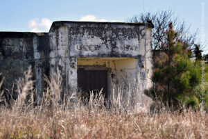
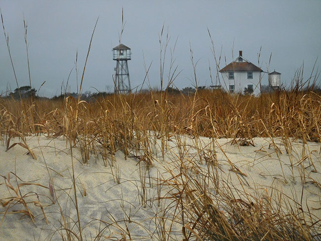
Few people realize that buried beneath the picturesque terrain at Cape Henlopen State Park in Delaware are a series of underground bunkers built to protect the U.S. from German invasions during World War II. The Cape has been an important strategic location for the U.S. Navy and Army throughout history from the time of the American Revolution right up through World War II. The area’s strategic position led to the construction of Fort Miles with its iconic fire control towers along the Atlantic coast. The coastal defenses date to 1941, when the fear of German U-boats invading Philadelphia via the Delaware River led to the construction of secret, state-of-the-art installations built within the massive natural sand dunes that provided the perfect cover for an array of heavy guns. The big guns were capable of firing artillery rounds up to 10 miles. A series of tunnels reportedly connects the bunkers, allowing the 2,500 soldiers that were stationed at Fort Miles to move undetected. Numerous bunkers, concrete observation towers and the pier built to accommodate the laying of mines on the harbor floor remain today. The site was officially decommissioned and transferred to the Delaware State Park system in 1964. Access to the abandoned bunkers and tunnels is limited to park officials, but the above ground structures are visible to visitors and it is possible to tour Battery 519 and climb to the top of the Observation Tower. The bunkers and towers are accessible from the north entrance to Cape Henlopen State Park, just off Route 9 in Lewes.
Nesconset | Paris | Belgrade | Cape May | Lewes | Berlin | Corolla | Awendaw | Ravenel | St. Augustine | Fort McCoy | Jacksonville

MORE NOTES FROM THE ROAD:
8-30 November – New Jersey
1-7 November – Cape Cod
27-31 October – Cape Cod
16-26 October – Long Island
1-15 October – Roadtrip East
23-30 September – Roadtrip East
16-22 September – Colorado
8-15 September – Moab LONCON
1-7 September – Roadtrip West
August – Long Island
July – Roadtrip North
June – Nomad Rally Start
23-31 May – Nomad Prep
16-22 May – Nomad Prep
8-15 May – Long Island
1-7 May – Long Island
16-30 April – East Coast
8-15 April – Long Island
1-7 April – Roadtrip Home
1-7 April – Roadtrip Home
22-31 March – DVE
15-21 March – Arizona
8-14 March – Joshua Tree
1-7 March – Glamis
20-28 February – Southwest Roadtrip
1-19 February – Woman and Machine
January – Woman and Machine
22-31 December – Holiday Roadtrip
16-21 December – Holiday Roadtrip
1-15 December – Long Island
Archive
ROADTRIP

An epic journey crisscrossing the USA from east to west and back again, exploring some of the beautiful wild spaces that make up our “public lands.” The roadtrip covered almost 15,000 miles, much of it off-grid and off-pavement, focusing on the deserts of the American southwest. Some locations were truly “iconic” while others were little known, and the segments of independent exploration where punctuated with some fun events across the region… [read]
SPECIAL REPORT
All about exploring ghost towns and abandoned places in the USA and beyond, with tips, and information on the many different types of sites to be found across the globe, including detailed guides for eight specific sites… [read]
REFLECTIONS

EGYPT: CAIRO REFLECTIONS
A quick overview of impressions from a stop in Cairo during our recent scouting mission in Egypt and Sudan … [read]
SPECIAL REPORT

A look into south-eastern Algeria on the border with Libya and Niger: overlanding with the Tuareg in one of the most remote corners of the Sahara … [read]
LOCATION
This installment of a series that focuses on locations around the USA takes a look at some favorite places near our home base in NY. We share a few places we like to explore, where you can experience something of the raw natural beauty of coastal beaches, pine barrens and a little bit of obscure military history… [read]