
< more recent | 22-31 December 2022 | older >
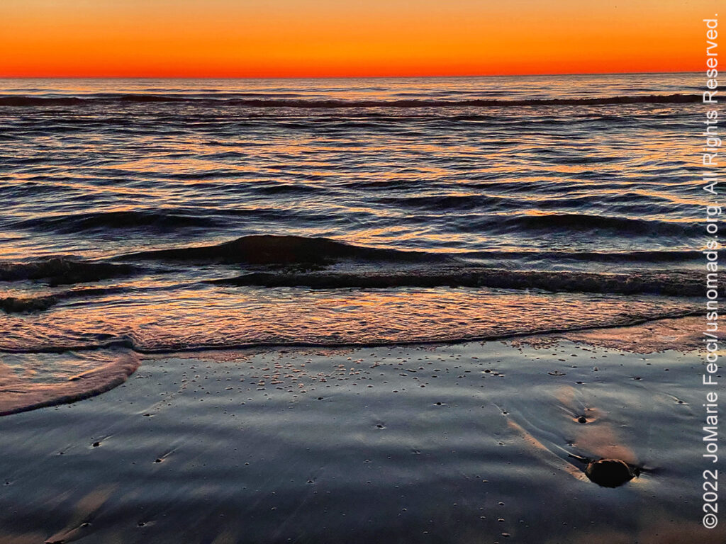
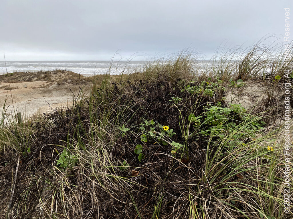
30 December 2022: Up before sunrise this morning to get out to the barrier island to catch the first light and the morning activity at the Chincoteague NWR and was not disappointed. An amazingly beautiful sunrise on the Atlantic transformed the beach into a vibrant abstract expressionist painting, then the animals started waking up and I had some good luck photographing and observing a small raccoon searching for food on the edge of the marsh, as well as a Great Blue Heron and an egret. After spending some time just observing the wildlife, I left the barrier island and got back on the road for the rest of the drive home to New York. The weather was good and the traffic surprisingly light until I reached the edge of the metro area where I got bogged down in NYC rush hour traffic. I crossed the last bridge to home just as the sun was setting over the city and made it to Long Island in time for dinner…
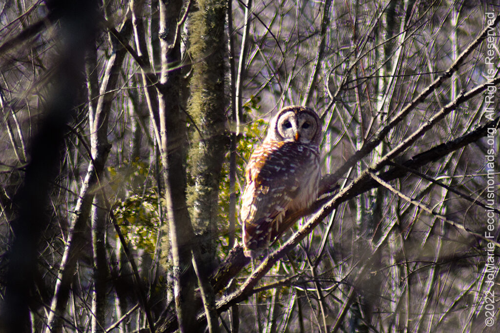
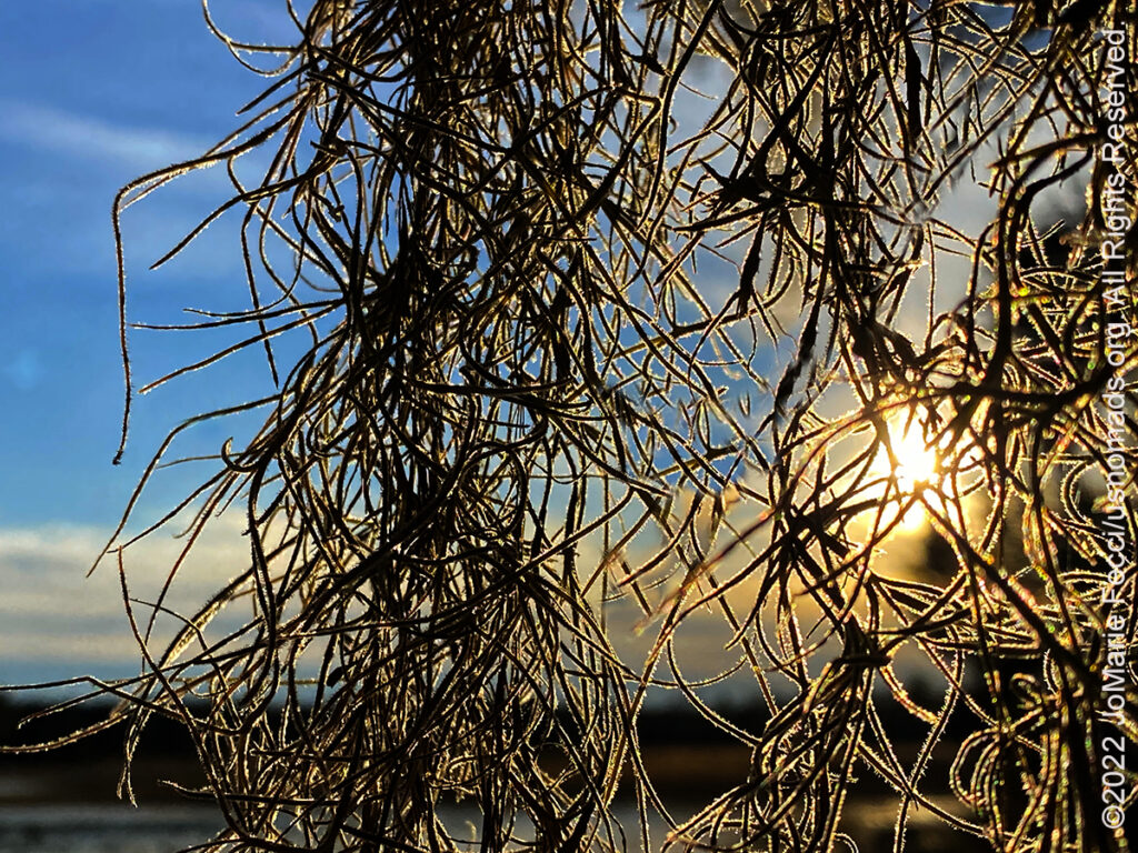
29 December 2022: Started the morning exploring the Great Dismal Swamp NWR, and it was interesting to see the swamp “frozen” with frost in some places. This swamp seems less dense and dark than the Okefenokee, but that may be because of it’s history of devastation by over-logging and not replanting. After a few short hikes and checking out the auto road to Lake Drummond, I left the refuge and headed for the state park on the other side of the swamp. As I was leaving the refuge I had the amazing luck to see and photograph an owl in daylight! Driving around the edge of the swamp, back into North Carolina and then up into Virginia again, I found a more “wild” and swamp-like landscape and even discovered the ruins of some kind of building in the woods (it made me think of the history of the Maroons in the swamp, but it was surely much more recently constructed and abandoned). At the state park I did another short hike and found the remains of a moonshine still that reflected on another aspect of “swamp life”. After leaving the Great Dismal Swamp I continued north east to the Delmarva Peninsula where the weather was almost spring like, and I reached Chincoteague Island just as the sun set over the bay…
28 December 2022: Today was a long drive day, heading north from Georgia through South Carolina, North Carolina and into Virgina. Temperatures increased the further north I went, and though I didn’t make any interesting stops along the way, I was well positioned to do some more exploring tomorrow…
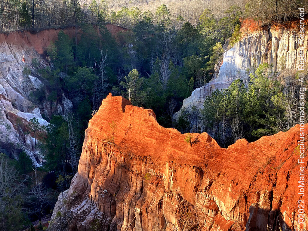
27 December 2022: I had made an ambitious plan, and the warmer weather was all I needed to get started with it. First up was Providence Canyon, sometimes called Georgia’s Little Grand Canyon, an amazingly beautiful and unexpected landscape for the southeast, with eroded canyons and colorful spires more typical of the west. Unfortunately they were doing some kind of construction that blocked off access to the trails that go along the canyon bottoms, but I was able to hike around the canyon rim. After wrapping up at the canyon, I set off to explore some Native American archaeological sites that I just learned about. The Ocmulgee Mounds National Historic Park has some impressive earth mounds from the Mississippian Culture and includes an earth lodge, which is something I had not seen before. This site was the subject of a major archaeological dig in the 1930s and has provided important insights into the Mississippian way of life. From there I continued on to the Oconee National Forest in a search for the Rock Hawk Effigy and the Rock Eagle Effigy, two unique works of rock art by ancient indigenous peoples in the area, that are rock piles designed in the form of a hawk and an eagle when seen from above …
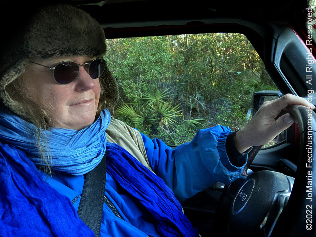
26 December 2022: It was a tiny bit warmer this morning, and the forecast said the weather would slowly improve over the next few days, but I was frozen through to my bones and decided to start the return trip heading north because I wasn’t really able to accomplish anything here while feeling so cold. I learned that I really do “shut down” when I am so cold, and can only focus my energy and attention on staying warm. So I changed the plan, and packed up camp, then made my way northwest, stopping at Micanopy for BBQ at Pearl’s, before leaving frozen Florida for Georgia. Ironically the temperature climbed as I drove north…
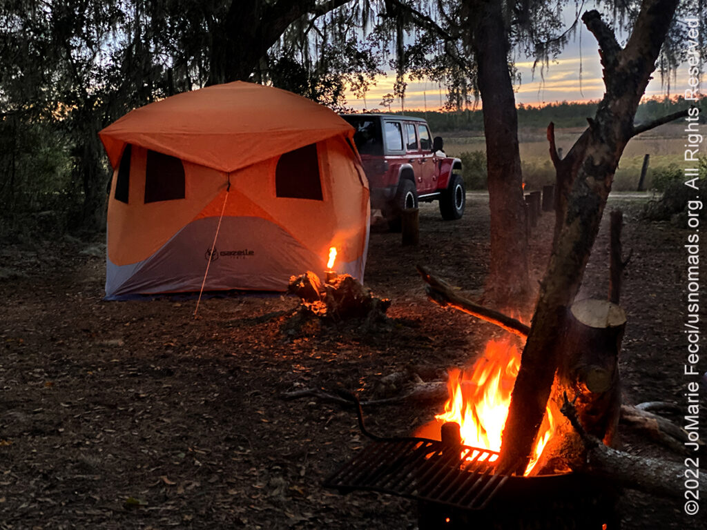
25 December 2022: Last night was really cold, even with the tent heater and all the layers of clothes. I woke up shivering and struggled to get out of the sleeping bag, though Mister Buddy was working hard to warm up the tent. It is so cold that the little heater can barely keep up, but it is definitely making it survivable if not exactly comfortable. Again I headed straight for the Jeep and the heated seats and steering wheel to “defrost” myself, and started Christmas morning off with a long drive to thaw out. I randomly came across the Fort King National Historic Landmark where I went for a short hike, then made another firewood recce picking up a few more tree trunks, including one taller than me. Back at camp I started the fire around 2pm and kept it burning till I went to bed around 10. My firewood strategy had worked out well and made it possible to celebrate the holidays outdoors even in this insane cold…
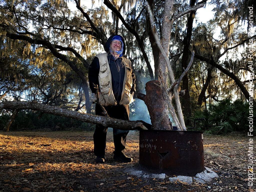
24 December 2022: It was freezing most of the day, and the morning was especially difficult. Thank God I have my “Mister Buddy” tent heater. I had it on most of the night, and again in the morning just so I could actually get out of bed. I have six layers of clothes on top and two on the bottom, not counting underwear, and I am still cold. I started the morning in the Jeep with the heater on, and drove around looking for firewood all morning partly to get more wood and partly just to keep warm. In the afternoon it went above freezing a little bit and I started the campfire around 1pm and kept it burning until I went to bed around midnight…
23 December 2022: Last night wasn’t bad at all, but tonite begins the big freeze. I haven’t been able to locate a tract of land in the forest where they are currently logging or clearcutting (the best areas to get a lot of firewood by gleaning what the loggers leave behind), so I am driving around looking for downed wood and loading it up in the Jeep as I go. I found a somewhat decent source of old tree trunks near the Shanty Pond area, which is currently closed to recreational use. Some of the logs are really heavy and one I had to half drag, half carry along the closed road to get it all the way to the Jeep — Forest Crossfit. Many of the fallen trees are too large to fit in the Jeep and too think to cut with my little handsaw, so I have to pick and choose carefully. Others are already beginning to rot, so would not make for good firewood. On a positive note, I have found a good mix of pine and hardwood, so I can use the pine to get the fire started and the hardwood to keep it burning long…
22 December 2022: Another grey cold and wet day in St. Augustine this morning, and I didn’t bother trying to catch a non-existent sunrise. Slowly made my way back towards camp in Ocala, very focused on the need to find a lot more firewood to keep warm during the freezing cold weather that is coming in with the arctic front for the holidays. Made a big supply run on the way to camp to be ready with everything I need for my holiday preparations. Luckily everything was pretty dry back at camp, and I set about getting organized …
THIS MONTH:

Holiday Roadtrip time. Getting ready to celebrate the Christmas holiday somewhere warmer and out in nature — will be setting up Christmas camp and enjoying exploring in the southeast this time…
COMING UP SOON:
Getting ready for the next big road trip. Heading southwest and into the desert for some new exploration as well as a few of our favorite events. Lots of details still to be determined, but it’s “on the calendar”…
![]()
USnomads.org is very proud to be presenting the second edition of the Nomad Overland Virtual Adventure Rally in 2023. This is a new kind of rally experience — a ten week event that participants can do from anywhere within the continental U.S.A. Competitors design their own routes as part of the rally, then drive it in a points-based online competition that includes optional activity tasks, quests and weekly challenges. The 2023 rally will run from 5 June – 13 August and is open to any driver within the United States who has an off-road capable vehicle — stock or modified. Registration for 2023 is open now. For more information see the Rally website …
THE GREAT DISMAL SWAMP
The Great Dismal Swamp is a large swamp in the Coastal Plain Region of southeastern Virginia and northeastern North Carolina. Archaeological evidence suggests varying cultures of humans have inhabited the swamp for 13,000 years. The Powhatan empire extended to the northern edge of the Great Dismal Swamp around the time of the settling of Jamestown, displacing the Chesapeake tribe residing there before. In 1650, Algonquian-speaking Native Americans lived in the swamp. In 1728, William Byrd II, while leading a land survey to establish a boundary between the Virginia and North Carolina colonies, made many observations of the swamp and he is credited with naming it the Dismal Swamp. At that time, the swamp was estimated to cover around 2,000 square miles. Settlers did not appreciate the ecological importance of wetlands. In 1763, George Washington visited the area, and he and others founded the Dismal Swamp Company in a venture to drain the swamp and clear it for settlement. The company later turned to the more profitable goal of timber harvesting. The Dismal Swamp Canal was authorized by Virginia in 1787 and by North Carolina in 1790. Construction began in 1793 and was completed in 1805. The canal, as well as a railroad constructed through part of the swamp in 1830, enabled the harvest of timber. At the same time, the swamp became a place of refuge for peoples looking to escape the colonial American system. Native American communities fled to the Swamp for refuge from the expanding colonial frontier. There was also multiple populations of Africans and African Americans taking refuge in the Swamp, many of them fleeing slavery — they became known as the Great Dismal Swamp maroons. The origin of the word maroon is uncertain, but it is widely believed that the word comes from the Spanish word cimarrón, meaning “wild” or “untamed”. Maroons, self-liberated Africans in isolated or hidden settlements, existed in all the Southern states, and swamp-based maroon communities could be found throughout the Deep South, in Alabama, Florida, Georgia, Louisiana, and South Carolina. They were able to find shelter, community and society in the swamp that wasn’t readily available outside. Most of those in the Great Dismal Swamp settled on mesic islands, the high and dry parts of the swamp. Inhabitants included people who had purchased their freedom as well as those who had escaped. Other people used the swamp as a route on the Underground Railroad as they made their way further north. Harriet Beecher Stowe told the maroon people’s story in her 1856 novel Dred: A Tale of the Great Dismal Swamp. Excavations reveal island communities existing until the Civil War. Charlie, a maroon who worked illegally in a lumber camp in the swamp, later recalled that there were whole families of maroons living in the Dismal Swamp, some of whom had never seen a white man. The Great Dismal Swamp maroons numbered in the thousands by the year 1860. The most significant research on the settlements began in 2002 with a project by Dan Sayers of American University. Results of a study published in 2007, “The Political Economy of Exile in the Great Dismal Swamp”, say that thousands of people lived there between 1630 and 1865, Native Americans, maroons and enslaved laborers on the canal. It is believed to have been one of the largest maroon colonies in the United States. Fear of slave unrest and fugitive slaves living in the maroon colony caused concern amongst local whites. A militia with dogs went into the swamp in 1823 in an attempt to remove the maroons and destroy their community, but most people escaped. In 1847, North Carolina passed a law specifically aimed at apprehending the maroons in the swamp. However, unlike other maroon communities, where local militias often captured the residents and destroyed their homes, those in the Great Dismal Swamp mostly avoided capture or the discovery of their homes. During the American Civil War, the United States Colored Troops entered the swamp to liberate the people there, many of whom then joined the Union Army. Most of the maroons who remained in the swamp left after the Civil War. In 1929, the United States Government bought the Dismal Swamp Canal and began to improve it. The canal is now the oldest operating artificial waterway in the country. Like the Albemarle and Chesapeake canals, it is part of the Atlantic Intracoastal Waterway. The Great Dismal Swamp National Wildlife Refuge was created in 1973 when the Union Camp Corporation of Franklin, Virginia, donated 49,100 acres of land after centuries of logging and other human activities devastated the swamp’s ecosystems. The Great Dismal Swamp National Wildlife Refuge contains some of the most important wildlife habitat in the mid-Atlantic region. At near 113,000 acres, the refuge is the largest intact remnant of a vast swamp that once covered more than one million acres. Outside the boundaries of the national wildlife refuge, the state of North Carolina has preserved and protected additional portions of the swamp through the establishment of the Dismal Swamp State Park. The park protects 22 square miles of forested wetland…
PROVIDENCE CANYON
Providence Canyon, located in Stewart County in southwest Georgia, is sometimes called Georgia’s “Little Grand Canyon” and is considered one of the Seven Natural Wonders of Georgia. The incongruity of this seemingly western landscape in the heart of the Deep South makes it an intriguing location, and for anyone curious as to how it came to be here, leads to a complex story tying man’s interaction with the environment to global socio-economic forces and the natural processes of erosion. Providence Canyon is not actually a purely natural feature—-many of the massive gullies, the deepest of which is more than 150 feet, are the result of poor farming practices in the 19th century. Providence Canyon State Park sits at the geographical center of the cotton plantation South, on the cusp of several major physiographical regions. Located in Stewart County, in the west-central part of Georgia, the network of canyons that makes up the park–the park actually contains sixteen “canyons”–covers approximately eleven hundred acres, but a large part of the county and parts of several adjoining counties are riddled with similar, if less notable, gullies. The gullies were a by-product of frontier settlement and the growth of the cotton-based economy. The first heavy influx of settlers in Stewart County came after the Treaty of Indian Springs in 1825, when the Creeks were forced to cede all their lands east of the Chattahoochee River. The gullies began to form soon after, and some were well formed by the Civil War. At its most basic, the soil erosion resulted from the removal of the vegetation that had anchored soils in place. Once the forested land was clear cut for agriculture, it was exposed to the erosive effects of rainfall and soils began their migrations downhill and into the region’s streams and rivers. The dominance in the South of clean-tilled monocrops (crops grown in rows with substantial uncovered soil in between) such as tobacco, cotton, and corn exacerbated these effects. Row-crop agriculture caused more severe soil loss and many early farmers plowed up and down slopes, rather than on the contour, which often magnified the erosivity of runoff resulting in extensive gullying. Land was abundant and cheap, so there was little impetus for soil conservation as farmland began washing and caving downward toward the Chattahoochee. Providence Canyon is the stunning visual result of the widespread erosion that came with plantation agriculture, slavery, tenancy, and international staple crop markets. The reliance on slave labor encouraged soil-negligent agriculture and investments in slaves encouraged southern planters to focus on cash crops and to channel as much labor as possible into staple production. In 1850, just a quarter century after settler agriculture first came to the region, Stewart County had 4,741 slaves and produced 19,165 bales of cotton, which ranked second among all Georgia counties. In 1859 a local congregation had to move its house of worship–the Providence Methodist Church–across a road to prevent the structure from sliding into an expanding chasm. Providence Canyon is named for that church that once teetered on its rim. Cotton production peaked in Stewart County around 1890, and the gullies of Stewart County continued to expand in the half century after the Civil War, until they covered tens of thousands of acres by the early twentieth century. Today a state park protects and preserves a unique and beautiful landscape where visitors can enjoy views of the canyons from the a trail or hike down into the deep gullies and explore the carved out formations close up. The canyon walls expose 43 different shades of soil ranging from light orange, salmon, red and scarlet to white, purple, and pink. One of the quirkier attractions of the state park is an abandoned homestead including nearly a dozen rusty, 1950s-era cars and trucks. Due to the environmental damage that removing the vehicles would cause, park officials have decided to leave them alone…
MORE NOTES FROM THE ROAD:
16-21 December – Holiday Roadtrip
1-15 December – Long Island
November – Long Island
22-31 October – Roadtrip East
15-21 October – Moab LONCON
8-14 October – Moab LONCON
1-7 October – Roadtrip West
22-30 September – Roadtrip West
16-21 September – Roadtrip West
1-15 September – Long Island
August – Long Island
15-31 July – Serbia
1-14 July – NE Roadtrip
16-30 June – NE Roadtrip
1-15 June – Long Island
May – Nomad Rally Prep
16-30 April – Long Island
7-15 April – Heading Back to NY
1-6 April – Heading Back to NY
27-31 March – Death Valley- DVE
21-26 March – LON Skills Camp
15-20 March – Death Valley
8-14 March – Nevada
1-7 March – Glamis Training
16-28 February – Roadtrip Southwest
1-15 February – Long Island
8-31 January – Long Island
1-7 January – Florida to NY
28-31 December – Okefenokee NWR
24-27 December – Ocala National Forest
19-23 December – Heading South
Archive
SPECIAL REPORT
All about exploring ghost towns and abandoned places in the USA and beyond, with tips, and information on the many different types of sites to be found across the globe, including detailed guides for eight specific sites… [read]
RE-OPENING
Report from the first trail run with the Off Road Consulting group at Rausch Creek Off Road Park as the post-pandemic phased re-openings begin in Pennsylvania and some of our favorite local trails re-open to the public after the two-month shutdown… [read]
REFLECTIONS

EGYPT: CAIRO REFLECTIONS
A quick overview of impressions from a stop in Cairo during our recent scouting mission in Egypt and Sudan … [read]
SPECIAL REPORT

A look into south-eastern Algeria on the border with Libya and Niger: overlanding with the Tuareg in one of the most remote corners of the Sahara … [read]