
< more recent | 16-22 September 2023 | older >
22 September 2023: Continued the drive to Ridgeway today, detouring near Montrose to go see the South Rim of the Black Canyon, which we couldn’t visit on the way west due to road construction on HWY 50. The South Rim is more heavily visited, and the scenic loop is paved, but the views are beautiful and because the time of day is also different from when we wer on the north side, very different looking. From there continued on to Ridgeway making a brief stop at the Ridgeway State Park around sunset…
21 September 2023: Took a fun and beautiful route to Cedaredge following the “road less travelled” back through part of the North Delta Open OHV area. Made a stop at the Ute Council Tree (or what’s left of it, more accurately), then just followed a beautiful route through the otherworldly landscapes back up to the Mesa from the other direction, and then down to the small town of Cedaredge …
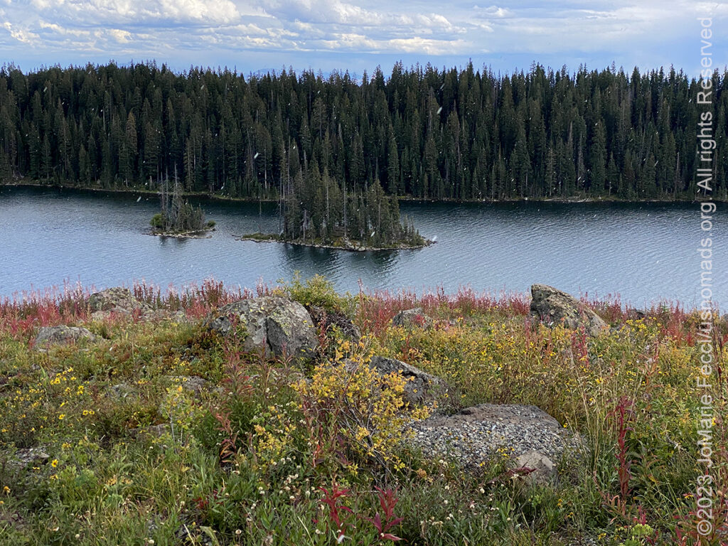
20 September 2023: Drove “up on the Mesa” as people refer to it here — the Grand Mesa National Forest, that sits high up on the big Mesa that defines the local landscape. Today we were “looking for moose” (or beavers, or prairie dogs), and of course found none of them, but did have a nice hike on the discovery trail by the Visitor Center before driving a couple of Forest Road trails and finding some beautiful locations and some interesting history including the old cabins of the Raber Cow Camp. And it even SNOWED for five minutes up there…
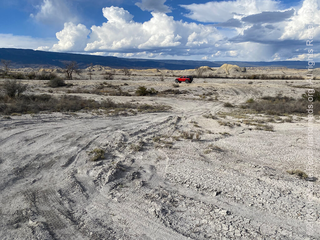
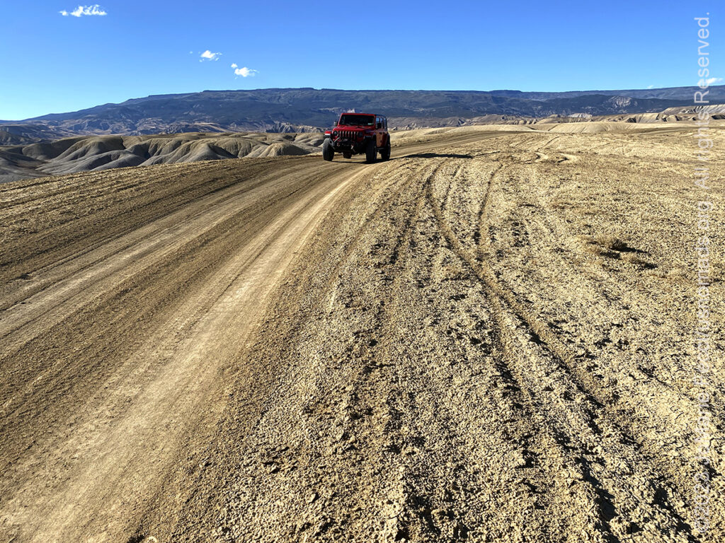
19 September 2023: Went looking for wildlife, prairie dogs specfically today, on a tip from someone at BLM that there were a whole bunch of them in a specific section of the Dominguez Escalante National Conservation Area. In fact there wasn’t a sign of them at all where we had noted the location on the map, and instead we just went exploring along the trail for a while. Later in the afternoon randomly “discovered” a really cool desert-like psuedo dune area, that we later learned was designated the North Delta Open OHV Area, managed by BLM and open to dispersed camping…
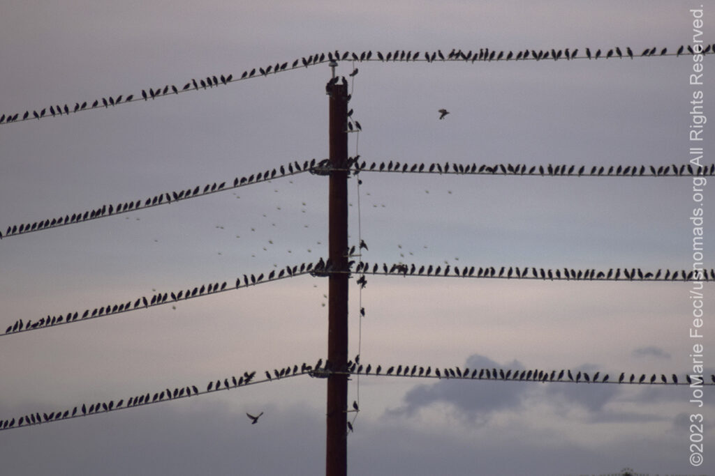
18 September 2023: Weather has turned again and it was very unsettled today, but did get out to the Colorado River to “look for beavers” which of course were not there (but made for a good excuse to go wandering with the camera). Did see some interesting bird behaviour possibly linked to the stormy weather. Or perhaps it’s an urban legend about birds gathering on the wires before a storm…
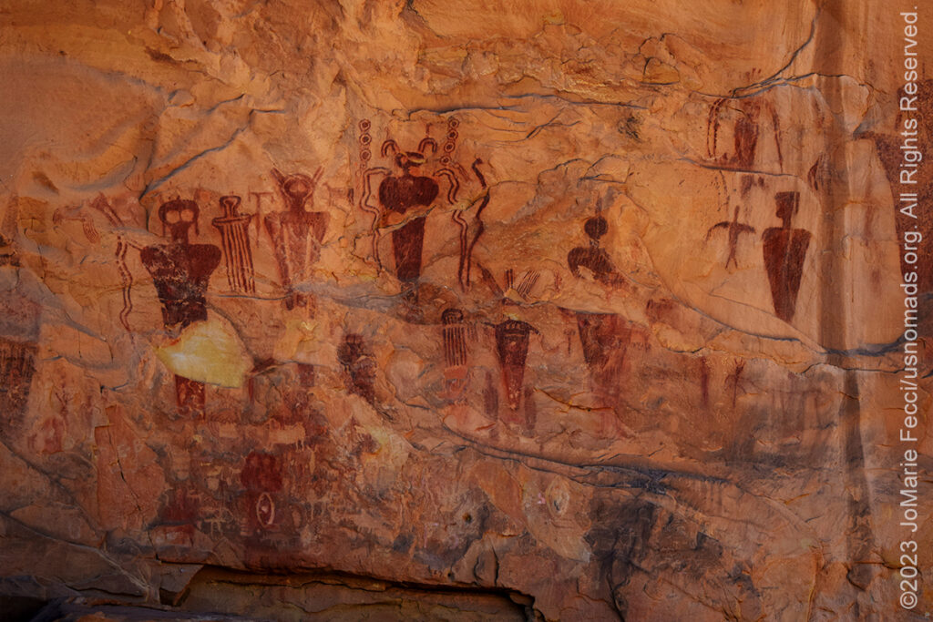
17 September 2023: Woke up early and broke camp, then continued the trail heading back towards “civilization” as slowly as possible. Paused to photograph the Moonflower Petroglyphs as we drove back along the Colorado River, and decided to go to Sego Canyon to pay a visit to that ancient rock art site, too. It was a beautiful day for being out on the trails, and exploring. Took some time photographing around the old mining town ruins at Sego, then decided to stop at one more “ghost town” before leaving Utah, and detoured into the old railroad town of Cisco (which isn’t really a “ghost” as some people live there and there is some commercial activity, but there are still some cool ruins and something of the “ghost town” atmosphere remains). Made it into Colorado just before sunset and settled in for the week in the town of Fruita …
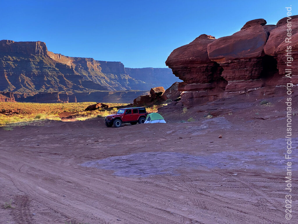
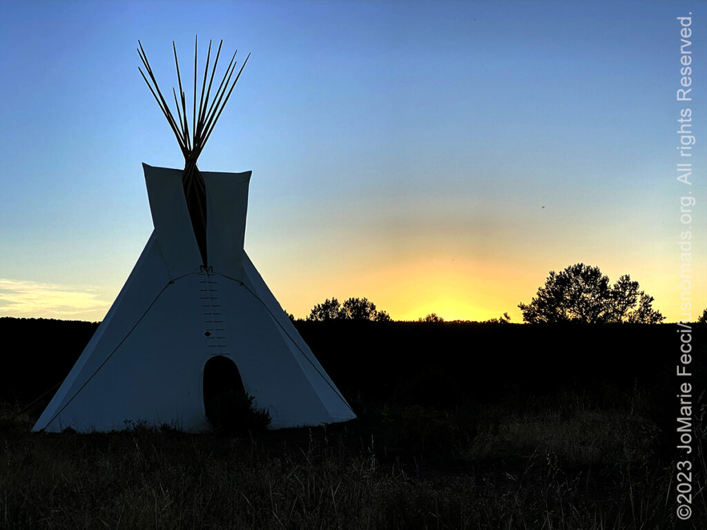
16 September 2023: Last night’s camp was at the Dead Horse Point State Park, and this morning was up early enough to catch the sunrise from Dead Horse Point. As the sun lit up the canyons below, we broke camp and headed down the Long Canyon trail which was not too busy so early in the morning. Came out to the Colorado River by Jug Handle arch, and followed the River back towards town, stopping to photograph some of the Petroglyphs on the rock walls along the way. In the afternoon we came back along the opposite bank of the Colorado to pick up the trail to Hurrah Pass and Chicken Corners. It was a quiet day on the trail and we only encountered a few other people out there. Set up camp for the night out by the Windcaves which was a perfect spot for a last night in Moab nestled between the magical Red Rocks under a blanket of stars …
THIS MONTH:

Heading southwest on a different route this time. Will be exploring some new places before reaching some old favorites. Moab it the ultimate “destination” where we will spend some time before turning back towards the northeast creating a “loop”…
![]()
Attending the Ladies Offroad Network Convention in Moab, UT. The 7th annual convention will be held September 11-15, 2023, with lots of hands-on opportunities to gain all types of offroading skills, learn and engage with other offroad ladies as they share their stories, and laugh the whole way. The convention is an action-packed, interactive week of educating, motivating, and guiding offroad ladies…
COMING UP SOON:

Attending Overland Expo East in Arrington, VA this year. Expo East will be held at the Oak Ridge Estates October 6-8, 2023, with more than 300 session-hours of incredible programs–that’s 150+ different classes, slideshows, demonstrations, and activities–brought to you by 100+ instructors and presenters from around the world. This is the premier overlanding event series with the largest scope of classes taught by the world’s leading experts alongside a professional-level trade show that brings together so many camping and vehicle and motorcycle equipment and services…
THE UTE COUNCIL TREE
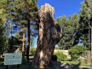
The Ute Council Tree is now just a big stump, which is somehow sadly symbolic in its own right, but the remains of this once towering Cottonwood tree still stands as a monument in the town of Delta, Colorado. This ancient tree was once part of a grove of native cottonwoods under which the local Ute Indians would camp and hold council prior to their forced removal from this area in 1881. The tree has been identified as the “Ute Council Tree” since 1930, when the local Daughters of the American Revolution chapter affixed a bronze plaque to the tree explaining its historic connection to the Utes. Some say that Chief Ouray and his wife Chipeta negotiated treaties with white settlers at the site of the council tree, though there is very little historical evidence to back that up. In fact, when these events would have taken place the tree would have been much smaller and indistinct from the other cottonwood trees that were there. Still, the centuries-old tree became linked with the Ute people and given historic significance. A seedling around 1800, it grew into a magnificent tree which survived for over 200 years. However, for the final 50-60 years of its life, branches continued to drop periodically, endangering life and property beneath. The tree was estimated to be over 215 years old at the time of its death, with a crown that reached 89 feet in the air. When the last major branch on the trunk dropped on August 1, 2017, leaving only the crown intact, the decision to remove the 89 foot crown was made in the interest of public safety. The Ute Council Tree was cut down on August 25, 2017, leaving the 23 foot stump as a memorial to the Ute Indians, who still embrace the historical connection of this tree to their ancestors who once inhabited the area…
DOMINGUEZ ESCALANTE NATIONAL CONSERVATION AREA
![]()
The Dominguez-Escalante National Conservation Area is a special place nestled within the remarkable canyon country of the Uncompahgre Plateau. Red-rock canyons and bluffs hold geological and paleontological resources spanning 600 million years, as well as many cultural and historic sites from the past 10,000 years. The Escalante, Cottonwood, Little Dominguez and Big Dominguez Creeks cascade through sandstone canyon walls that drain the eastern Uncompahgre Plateau. Unaweep Canyon on the northern boundary of the NCA contains globally significant geological resources. Nearly 30 miles of the Gunnison River flow through Dominguez-Escalante NCA, supporting fish, wildlife and recreational resources…
ABOUT SEGO CANYON
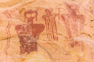
The Sego Canyon Petroglyphs found on the sandstone cliffs indicate a holy place. Native Americans painted and chipped their religious visions, clan symbols, and records of events onto the cliffs. There are three distinct styles present which represent three separate cultures and time periods. The “Barrier Canyon Petroglyphs” (6000 B.C. – 100 B.C.) are attributed to Archaic people. Archaic people were nomads, hunting large and small game animals, collecting and processing wild plants. They did not build permanent habitation structures, but lived in caves and in small brush shelters built in the open. They occupied this area from approximately 8,000 years ago until the introduction of corn agriculture about 2,000 years ago. The Barrier Canyon style of rock art usually consists of larger than life size anthropomorphic (manlike) forms. The identifying characteristic of these figures is hollowed eyes or missing eyes, the frequent absence of arms and legs, and the anthropomorphs with bug-eyes, antennae, earrings, snakes in hand, and leg-less torsos. The “ghost-like” images, may represent shamanistic art associated with ritual activities of the Archaic people. The “Fremont Indian Petroglyphs” (600 A.D. – 1250 A.D.) date to the period when the Fremont Culture thrived and was contemporary with the Anasazi Culture of the Four Corners area. Like the Anasazi, the Fremont planted corn and lived in pithouses and surface stone structures. They constructed a distinctive basketry and made pottery. They had a complex social structure, as is illustrated in their rock art, and were highly adaptive to the extremes of their environment. At the top of the panel are the oldest figures. These are the line of large, red-painted figures with the rectangular-bodies and small-heads, which are similar to the Anasazi Basket maker style. Superimposed on the older, painted figures is a line of carved (pecked) human figures. Typically, these have trapezoids for the head and body. The most recent Freemont period is also represented by superimposed carvings. They are deeply groved outlines of two life-sized human figures with collars and waistbands, and the associated mountain sheep and abstract elements. This last group is representative of the Classic Fremont Style. The “Ute Indian Petroglyphs” (1300 A.D. – 1880 A.D.) are clearly identified and dated by the horse and rider figures. Horses were introduced to North America by the Spanish in the sixteenth century. Other figures, or elements, painted in red and white on the panel include a white bison, a human figure with leggings, several large human figures, and large circles believed to be shields. The Ute people practiced a hunting and gathering lifeway. They used the bow and arrow, and made baskets and brownware pottery, and lived in brush wikiups and tipis. The No-tah (Ute people) lived freely throughout western Colorado and eastern Utah until about 1880, when they were forced onto reservations…
MORE NOTES FROM THE ROAD:
8-15 September – Moab LONCON
1-7 September – Roadtrip West
August – Long Island
July – Roadtrip North
June – Nomad Rally Start
23-31 May – Nomad Prep
16-22 May – Nomad Prep
8-15 May – Long Island
1-7 May – Long Island
16-30 April – East Coast
8-15 April – Long Island
1-7 April – Roadtrip Home
1-7 April – Roadtrip Home
22-31 March – DVE
15-21 March – Arizona
8-14 March – Joshua Tree
1-7 March – Glamis
20-28 February – Southwest Roadtrip
1-19 February – Woman and Machine
January – Woman and Machine
22-31 December – Holiday Roadtrip
16-21 December – Holiday Roadtrip
1-15 December – Long Island
November – Long Island
22-31 October – Roadtrip East
15-21 October – Moab LONCON
8-14 October – Moab LONCON
1-7 October – Roadtrip West
Archive
SPECIAL REPORT
All about exploring ghost towns and abandoned places in the USA and beyond, with tips, and information on the many different types of sites to be found across the globe, including detailed guides for eight specific sites… [read]
REFLECTIONS

EGYPT: CAIRO REFLECTIONS
A quick overview of impressions from a stop in Cairo during our recent scouting mission in Egypt and Sudan … [read]
SPECIAL REPORT

A look into south-eastern Algeria on the border with Libya and Niger: overlanding with the Tuareg in one of the most remote corners of the Sahara … [read]