
< more recent | 8-15 September 2023 | older >
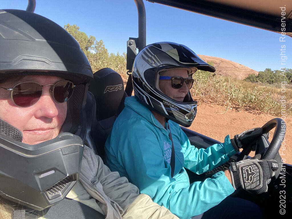
15 September 2023: For this year’s Adventure Day, Ladies Offroad Network got together with Polaris to provide us all with a guided trail day out on Polaris RZRs. We got to check drive them on two of Moab’s most iconic trails, “Fins N Things” and “Hell’s Revenge” and while we only had time to do part of each trail it was a fun experience and a great way to wind up the Convention activities…
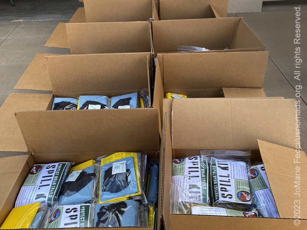
14 September 2023: Joined the ladies from the 2023 Ladies Offroad Network Convention for this year’s “Giveback Project” today. We spent the afternoon assembling 1,000 Spill Kits to be handed out on Moab trails to help people “Travel Responsibly” out there…
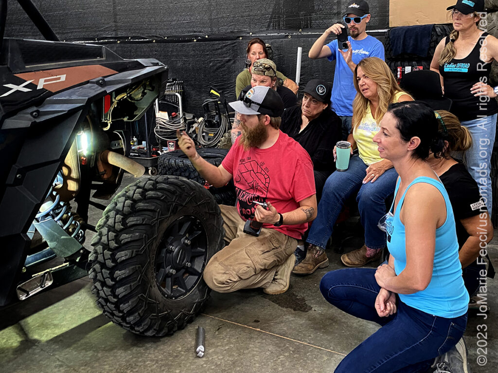
13 September 2023: Taught a “Route Planning and Navigation” seminar and sat in on a class about UTV mechanical issues and field repairs as part of the annual Ladies Offroad Network Convention that is happening all week in the Moab area …
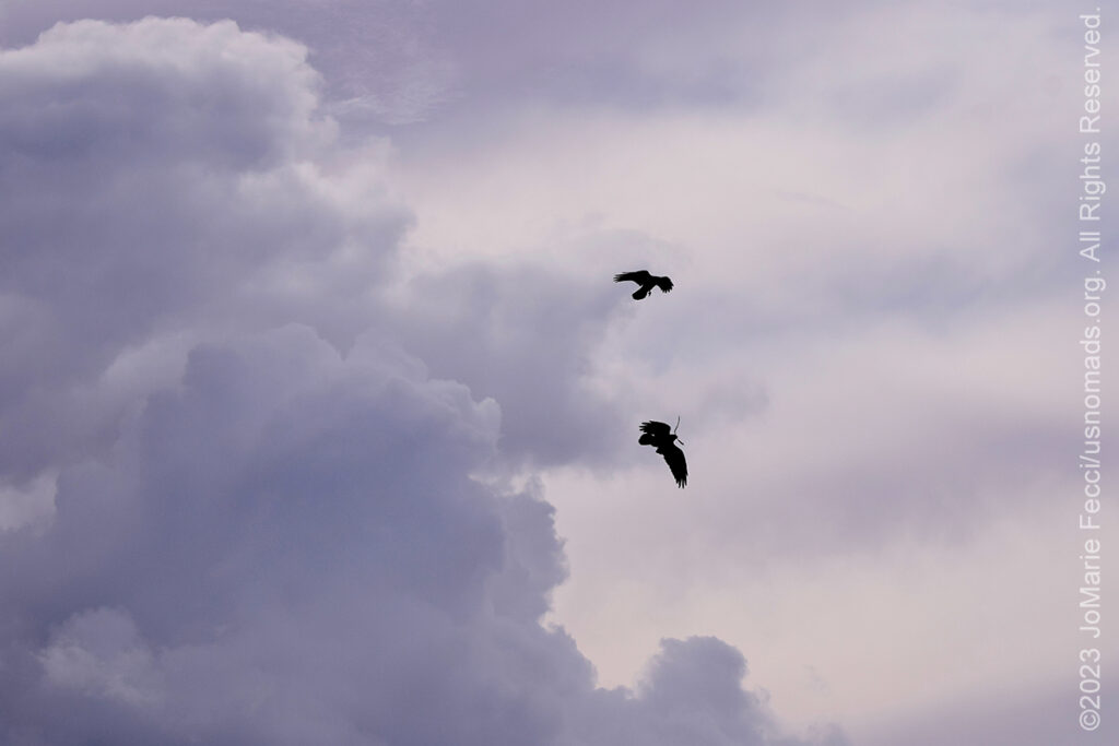
12 September 2023: A day of wet and wind out on the red rocks. Turbulent skies with fast moving clouds in the Canyonlands today. Spent some time watching a pair of birds battling the wind as they soared above the canyons…
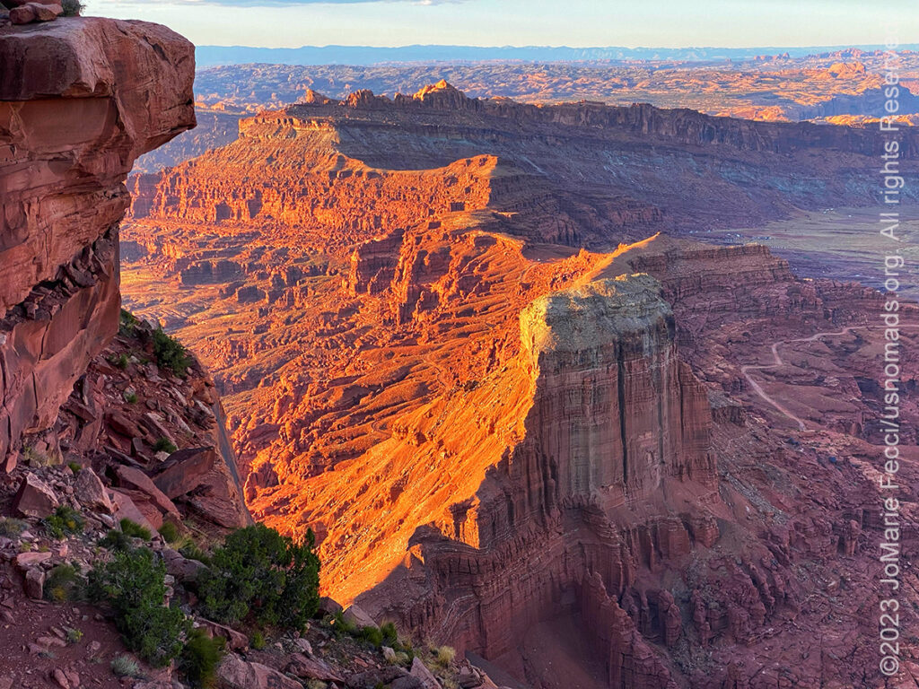
11 September 2023: Decided to go to the Anticline Overlook via a dirt route made a little more complicated by some detours for roadwork on the main route into the Needles. The best part of the day was there was nobody else out there and the overlook was glowing in the late afternoon light…
10 September 2023: Made the last leg of the westbound journey after lingering a bit at camp in the morning, and arrived in Moab in the afternoon to settle in for the week…
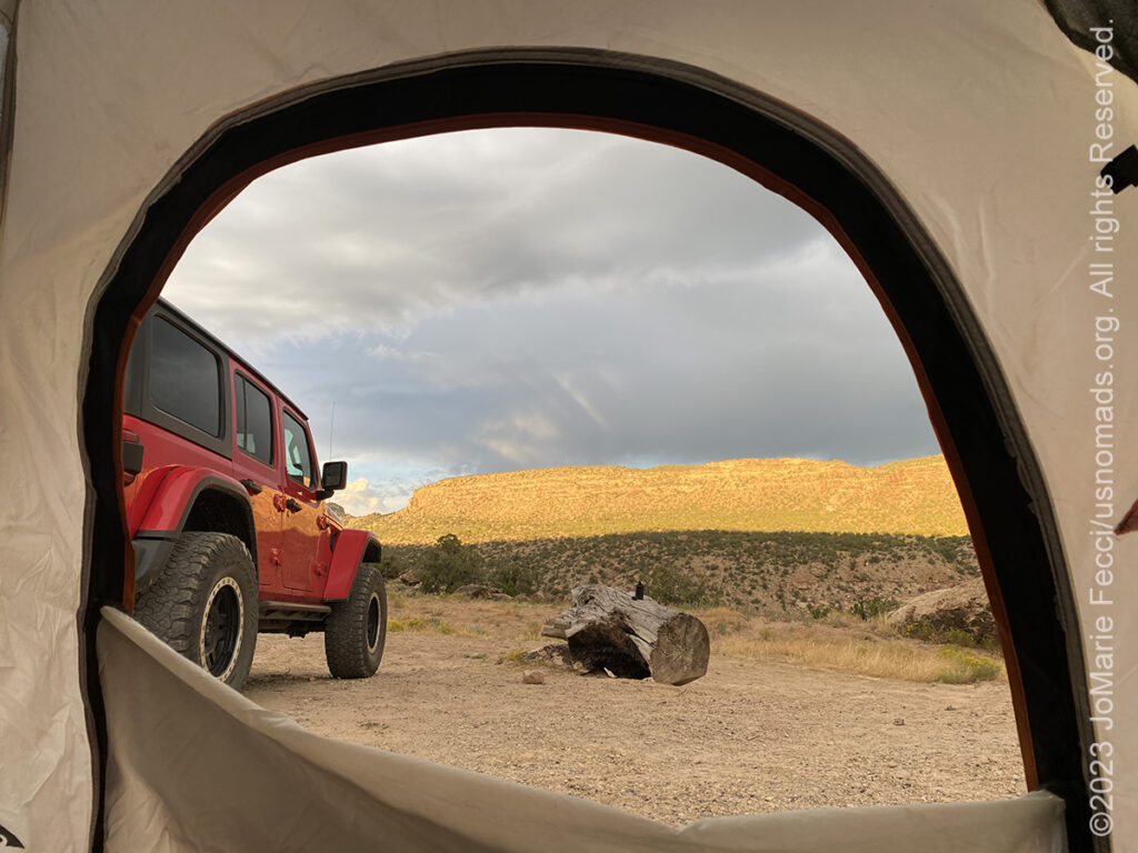
9 September 2023: Woke up early and headed into the park to explore the North Rim of the Black Canyon a bit before continuing westward towards Grand Junction to resupply and then set up camp in a dispersed site off HWY 141 nestled between some red rocks with a clear view of the night sky once again…
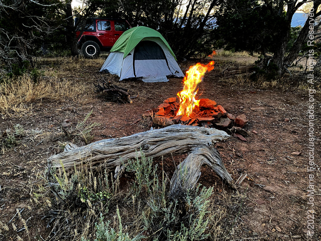
8 September 2023: Headed out along Highway 50 with the intention of going to camp at the East Portal campground along the South Rim of the Black Canyon of the Gunnison National Park, but roadwork with 2-hour long delays before Montrose caused a change in plan. Turned around and went up 92 instead, which turned out to be a good decision, as the road itself is a beautiful scenic drive up along the edges of the mountains and fins to the top of the canyon on the North Rim. Got to the campground on the North Rim around 4pm-ish and found it was full. Frustrated and thinking the only solution was to go all the way back down to Hwy 50 to find a place to camp, was glad when we noticed a big RV out in the middle of nowhere just outside the borders of the national park. Took a closer look and saw it was BLM land and open to dispersed camping, so ended up finding a gorgeous camp spot tucked in between some trees besides a nice open area perfect for watching the stars at night. Was so clear we could even see the Milky Way …
THIS MONTH:

Heading southwest on a different route this time. Will be exploring some new places before reaching some old favorites. Moab it the ultimate “destination” where we will spend some time before turning back towards the northeast creating a “loop”…
![]()
Attending the Ladies Offroad Network Convention in Moab, UT. The 7th annual convention will be held September 11-15, 2023, with lots of hands-on opportunities to gain all types of offroading skills, learn and engage with other offroad ladies as they share their stories, and laugh the whole way. The convention is an action-packed, interactive week of educating, motivating, and guiding offroad ladies…
COMING UP SOON:

Attending Overland Expo East in Arrington, VA this year. Expo East will be held at the Oak Ridge Estates October 6-8, 2023, with more than 300 session-hours of incredible programs–that’s 150+ different classes, slideshows, demonstrations, and activities–brought to you by 100+ instructors and presenters from around the world. This is the premier overlanding event series with the largest scope of classes taught by the world’s leading experts alongside a professional-level trade show that brings together so many camping and vehicle and motorcycle equipment and services…
THE ANTICLINE OVERLOOK
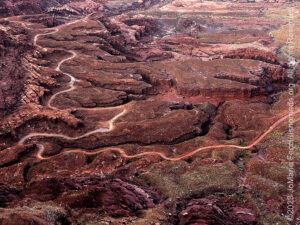
Moab’s Anticline Overlook, near the Needles District of Canyonlands National Park, is actually located in the BLM controlled Canyon Rims Recreation Area, which spans most of the area between Moab and Monticello. It is one of the area’s less visited sites — perhaps because it’s name sounds so “geological” and “science-y” versus the more romantic evocative sounding names of so many other places around here. In any case it is definitely worth a visit. The Anticline Overlook is a great place to get a sense of the vastness of this otherworldly landscape of nested canyons and eroded rock formations. An “anticline” is simply an uplifted fold in the rock layers. Typically anticlines are rich in minerals and petroleum deposits with most of the world’s petroleum being found in anticlines. Moab’s Anticline Overlook sits at 5,700 feet elevation offering an amazing overview of the whole area below. Hurrah Pass, directly below the overlook is at 4,780 feet. Potash, along the far bank of the Colorado River is at 4,025 feet. From the Overlook you can see and almost feel the Earth’s curvature. There is an unobstructed view south to the Abajo Mountains. On a clear day, you will see the Henry Mountains farther south. Looking southwest across the Colorado River, you will see Dead Horse Point State Park. There are a few different ways to reach the Anticline Overlook, but the most fun is to pick a route that goes on dirt with some fun detours to make a full trail day out of it…
BLACK CANYON OF THE GUNNISON
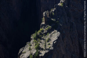
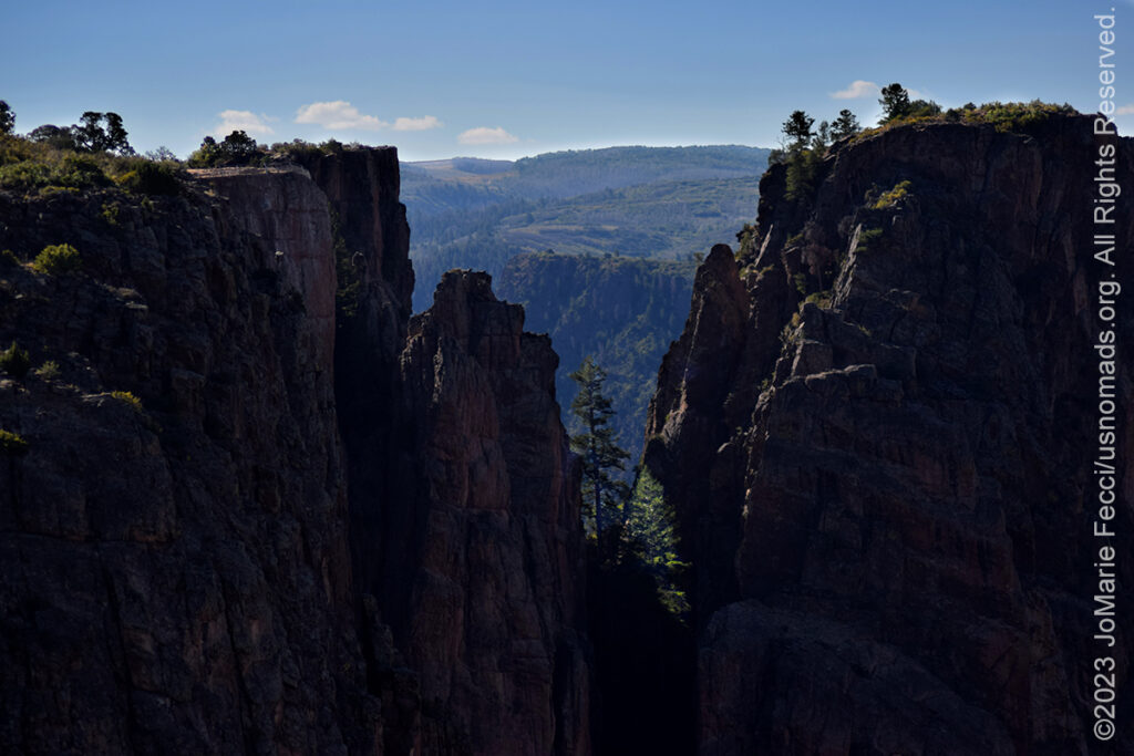
The Black Canyon of the Gunnison National Park, located in western Colorado, exposes visitors to some of the steepest cliffs, oldest rock, and craggiest spires in North America. The canyon’s name owes itself to the fact that parts of the gorge only receive 33 minutes of sunlight a day creating a landscape that mixes depth, sheerness, narrowness, and darkness with a rushing river studded with boulders to evoke a truly rugged wilderness. At its narrowest point the canyon is only 40 ft wide at the river. The park contains the deepest and most dramatic section of the canyon which is about 12 miles, but the canyon continues upstream into Curecanti National Recreation Area and downstream into Gunnison Gorge National Conservation Area for a total of 48 miles. This vertical wilderness of rock, water, and sky was sculpted by the Gunnison River (with some help from the forces of weathering) over two million years. The river drops an average of 34 feet per mile through the entire canyon, making it the 5th steepest mountain descent in North America. The greatest descent of the Gunnison River occurs within the park at Chasm View dropping 240 feet per mile. The extreme steepness and depth of the Black Canyon formed as the result of several geologic processes acting together. The Gunnison River is primarily responsible for carving the canyon, though several other geologic events had to occur in order to form the canyon as it is seen today. The Precambrian gneiss and schist that make up the majority of the steep walls of the Black Canyon formed 1.7 billion years ago during a metamorphic period brought on by the collision of ancient volcanic island arcs with the southern end of what is present-day Wyoming. The entire area underwent uplift during the Laramide orogeny between 70 and 40 million years ago which was also part of the Gunnison Uplift. This raised the Precambrian gneiss and schist that makes up the canyon walls. During the Tertiary from 26 to 35 million years ago large episodes of volcanism occurred in the area immediately surrounding the present day Black Canyon. The West Elk Mountains, La Sal Mountains, Henry Mountains, and Abajo Mountains all contributed to burying the area in several thousand feet of volcanic ash and debris. The modern Gunnison River set its course 15 million years ago as the run-off from the nearby La Sal and West Elk Mountains and the Sawatch Range began carving through the relatively soft volcanic deposits. With the Gunnison River’s course set, a broad uplift in the area 2 to 3 million years ago caused the river to cut through the softer volcanic deposits. Eventually the river reached the Precambrian rocks of the Gunnison Uplift. Since the river was unable to change its course, it began scouring through the extremely hard metamorphic rocks of the Gunnison Uplift. The river’s flow was much larger than currently, with much higher levels of turbidity. As a result, the river dug down through the Precambrian gneiss and schist at the rate of 1 inch every 100 years. The extreme hardness of the metamorphic rock along with the relative quickness with which the river carved through them created the steep walls that can be seen today. A number of feeder canyons running into the Black Canyon slope in the wrong direction for water to flow into the canyon. It is believed that less-entrenched streams in the region shifted to a more north-flowing drainage pattern in response to a change in the tilt of the surrounding terrain. The west-flowing Gunnison, however, was essentially trapped in the hard Precambrian rock of the Black Canyon and could not change its course.The Ute had known the canyon to exist for a long time before the first Europeans saw it. They referred to the river as “much rocks, big water,” and are known to have avoided the canyon out of superstition. In the 1800s, the numerous fur trappers searching for beaver pelts would have known of the canyon’s existence but they left no written record. The first official account of the Black Canyon was provided by Captain John Williams Gunnison in 1853, who was leading an expedition to survey a route from Saint Louis and San Francisco. He described the country to be “the roughest, most hilly and most cut up,” he had ever seen, and skirted the canyon south towards present-day Montrose. Following his death at the hands of the Ute later that year, the river that Captain Gunnison had called the Grand was renamed in his honor…
MORE NOTES FROM THE ROAD:
1-7 September – Roadtrip West
August – Long Island
July – Roadtrip North
June – Nomad Rally Start
23-31 May – Nomad Prep
16-22 May – Nomad Prep
8-15 May – Long Island
1-7 May – Long Island
16-30 April – East Coast
8-15 April – Long Island
1-7 April – Roadtrip Home
1-7 April – Roadtrip Home
22-31 March – DVE
15-21 March – Arizona
8-14 March – Joshua Tree
1-7 March – Glamis
20-28 February – Southwest Roadtrip
1-19 February – Woman and Machine
January – Woman and Machine
22-31 December – Holiday Roadtrip
16-21 December – Holiday Roadtrip
1-15 December – Long Island
November – Long Island
22-31 October – Roadtrip East
15-21 October – Moab LONCON
8-14 October – Moab LONCON
1-7 October – Roadtrip West
Archive
SPECIAL REPORT
All about exploring ghost towns and abandoned places in the USA and beyond, with tips, and information on the many different types of sites to be found across the globe, including detailed guides for eight specific sites… [read]
REFLECTIONS

EGYPT: CAIRO REFLECTIONS
A quick overview of impressions from a stop in Cairo during our recent scouting mission in Egypt and Sudan … [read]
SPECIAL REPORT

A look into south-eastern Algeria on the border with Libya and Niger: overlanding with the Tuareg in one of the most remote corners of the Sahara … [read]