
< more recent | 23-30 September 2023 | older >
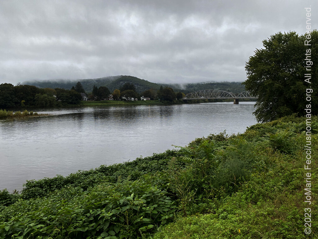
30 September 2023: It was wet and foggy in the morning, but the rain was light now, and major flooding had receded. Took a short break to photograph the Delaware River from Port Jarvis before continuing on…
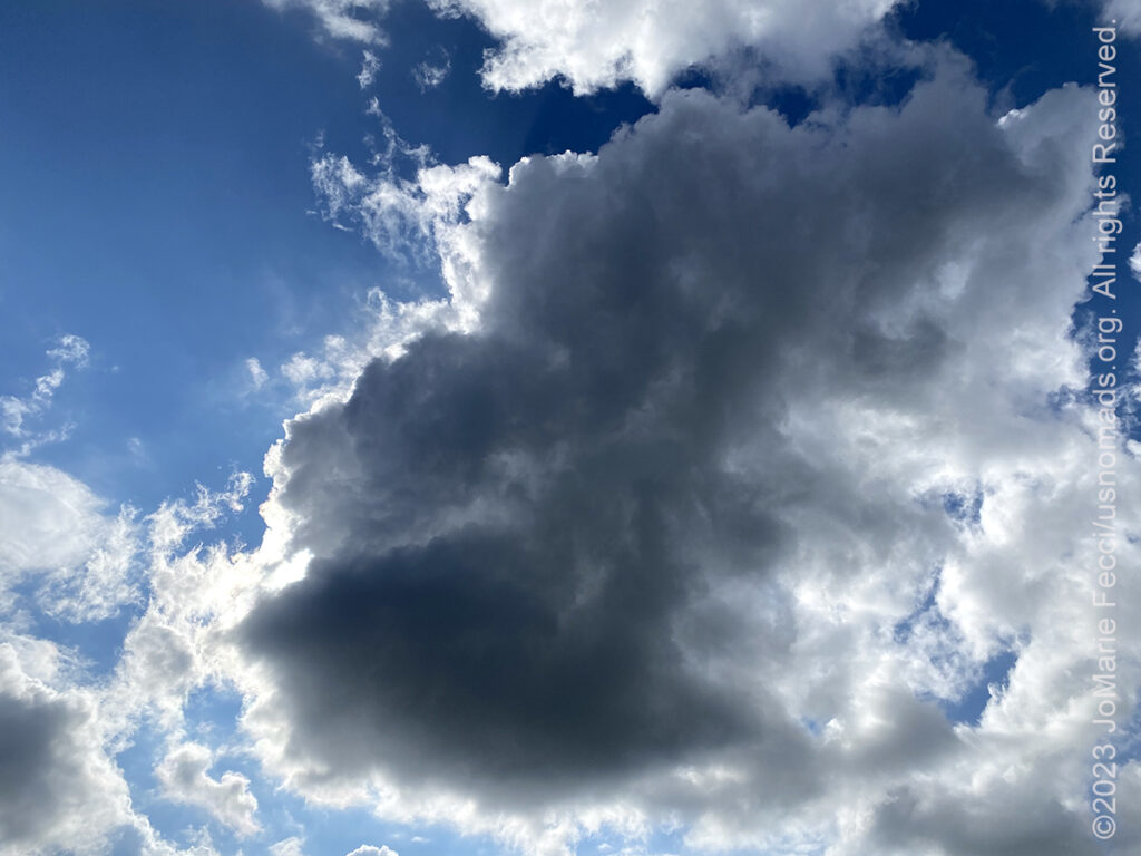
29 September 2023: Started the drive with blue skies but about midway the clouds started rolling in and rain threatened. Weather reports said it was very heavy in NY and NJ with much flooding, but in PA it was just light showers. Stopped for the night in Scranton…
![]()
28 September 2023: Crossed that 100th Meridian at some point yesterday and was now firmly back on the “eastern” side of the US (even if it is called the “midwest”) where there is more green in the landscapes and forest colors replace the arid desert-y palette. Started the day near Fort Belmont, a historical park of sorts, focused on pioneer life. Though the park itself was closed it was still possible to walk around the outside of the structures and make a few photos. Then stopped again on the west bank of the Mississippi River to have a short hike at the Great River Bluffs State Park, where the first colors of fall foliage were starting to appear …
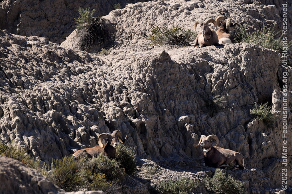
27 September 2023: Had some more good luck at Badlands and got to see some of the Bighorn Sheep lazing about on the eroded rocky landscapes before leaving the area and getting back on the highway to begin the real “marathon” back to the east. Did take time out for a stop at the Mitchell Prehistoric Indian Village Archaeological site, which was really interesting as the site is a working dig site, but with a lot of interpretive information that explains the process of understanding the artifacts found there and putting them in the narrative context of the anthropological period…
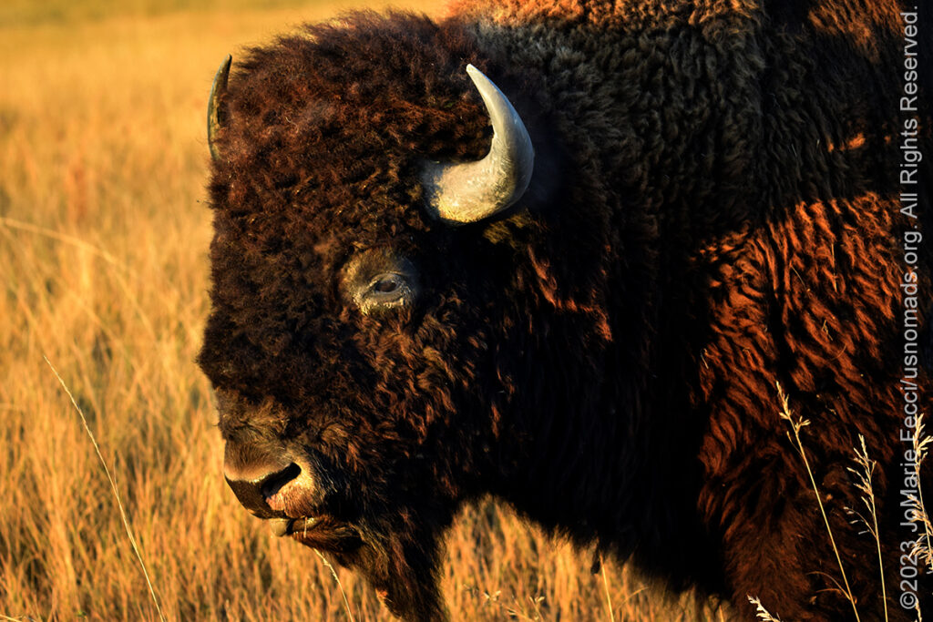
26 September 2023: Made only a short stop at Scottsbluff National Monument, as the light was not that great for photos, and there was a long drive to make it to Badlands National Park before sunset. But arrived to the park via Sage Creek road (which they are in the process of paving, unfortunately) just in time to catch the last bit of the golden light of late afternoon, and the buffalo…
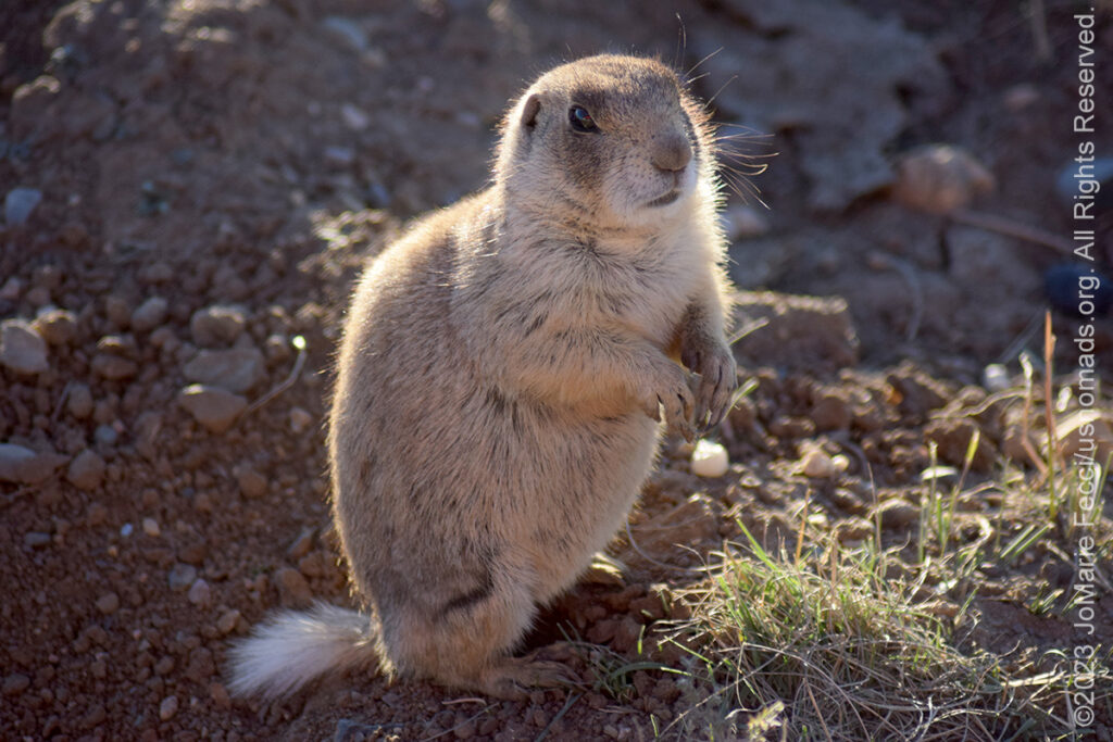
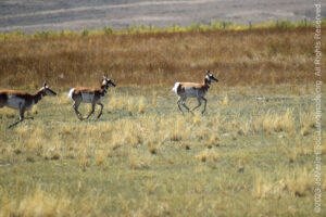
25 September 2023: Great wildlife day today at the refuge, with lots of prairie dogs, pronghorn antelope and even had a rare chance to see a burrowing owl — actually found it while looking for prairie dogs in the distance. Saw something on the ground behind some brush that just didn’t have the profile of a prairie dog, and had to look at it with the telephoto lens to confirm that it was indeed an owl! Very good day (no moose, and no time to go looking for them at a location we heard is the best place for sighting them because it was already getting late and the location was in the opposite direction)…
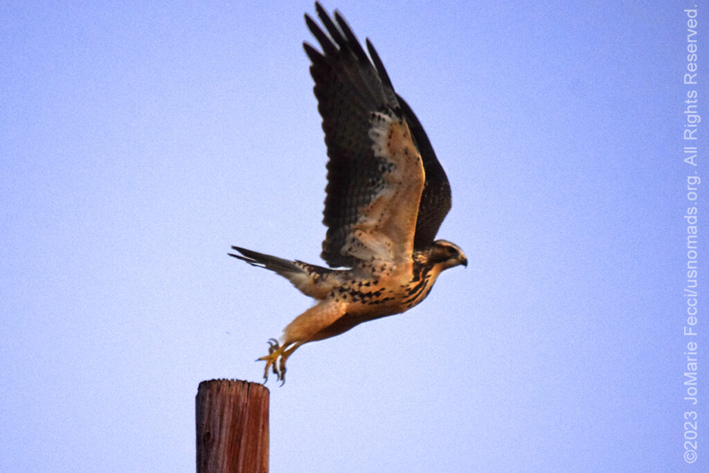
24 September 2023: Started the route back to the northeast today, making a detour to the Araphao National Wildlife Refuge to go see the Prairie Dogs that we’d been unable to find in these other places in Colorado. Took the “slow road” following HWY 133 up through an active coal mining area as well as through some more historical mining sites near Redstone, then on into the White Mountain National Forest, before turning off towards the Refuge. Arrived at dusk, and did a loop around the western property, where the prairie dogs were already sheltered in their burrows for the evening, and a few hawks scanned the landscape looking for dinner. Went to the east property where the “Moose and Goose” hiking trail is, but there were cows grazing everywhere and the likelihood of seeing a moose was slim. Did get some nice photos of one of the hawks taking off in flight which was really cool …
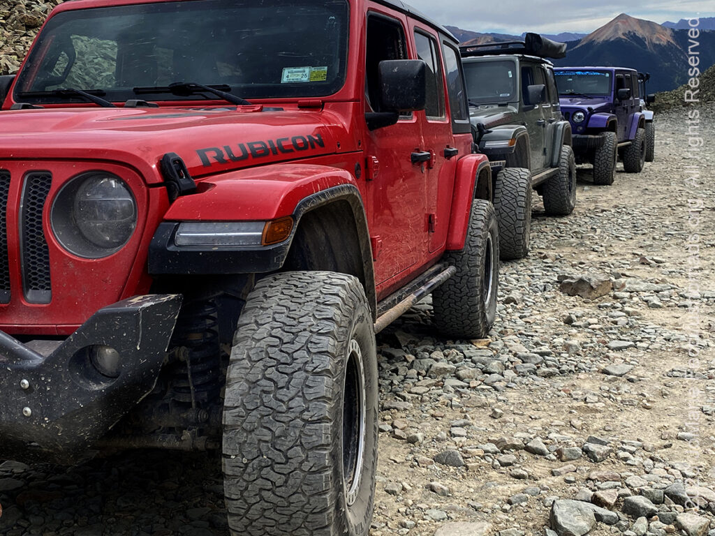
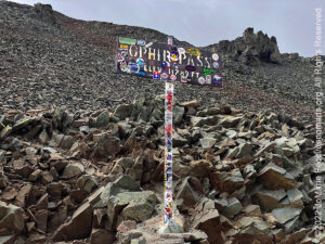
23 September 2023: Was invited to join a group from the San Juan Mountain Trails organization on a run in the scenic mining country around Ouray and we hit the trails in the morning with a small group of mostly Jeeps. The mountains are truly majestic and the trails were easy driving but the challenge was in the steepness and elevation. We were going up almost 12,000 feet in some cases — the tops of the mountains were “above the treeline” and all full of what looked like rock piles making for an edge of the world sensation, especially at Ophir Pass, which is a narrow road between two peaks of bolder piles …
THIS MONTH:

Heading southwest on a different route this time. Will be exploring some new places before reaching some old favorites. Moab it the ultimate “destination” where we will spend some time before turning back towards the northeast creating a “loop”…
![]()
Attending the Ladies Offroad Network Convention in Moab, UT. The 7th annual convention will be held September 11-15, 2023, with lots of hands-on opportunities to gain all types of offroading skills, learn and engage with other offroad ladies as they share their stories, and laugh the whole way. The convention is an action-packed, interactive week of educating, motivating, and guiding offroad ladies…
COMING UP SOON:

Attending Overland Expo East in Arrington, VA this year. Expo East will be held at the Oak Ridge Estates October 6-8, 2023, with more than 300 session-hours of incredible programs–that’s 150+ different classes, slideshows, demonstrations, and activities–brought to you by 100+ instructors and presenters from around the world. This is the premier overlanding event series with the largest scope of classes taught by the world’s leading experts alongside a professional-level trade show that brings together so many camping and vehicle and motorcycle equipment and services…
SCOTTS BLUFF
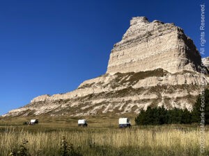
Scotts Bluff National Monument is located west of Gering, Nebraska. This National Park Service site protects over 3,000 acres of historic overland trail remnants, mixed-grass prairie, rugged badlands, towering bluffs and riparian area along the North Platte River. The monument’s north bluff is named after Hiram Scott, who was a clerk for the Rocky Mountain Fur Company and died near the bluff in 1828. The local Native Americans had called it Me-a-pa-te, “the hill that is hard to go around.” The bluff served as an important landmark on the Oregon Trail, California Trail and Pony Express Trail, and was visible at a distance from the Mormon Trail. Over 250,000 westward emigrants passed by Scotts Bluff between 1843 and 1869. It was the second-most referred to landmark on the Emigrant Trails in pioneer journals and diaries. The collection of bluffs was first charted in 1812 by the Astorian Expedition of fur traders traveling along the river. The expedition party noted the bluffs as the first large rock formations along the North Platte River where the Great Plains started giving way to the foothills of the Rocky Mountains. Fur traders, missionaries, and military expeditions began regular trips past Scotts Bluff during the 1830s. Beginning in 1841, multitudes of settlers passed by Scotts Bluff on their way west along the Great Platte River Road to Oregon, and later California and Utah. All these groups used the bluff as a major landmark for navigation. Although a natural gap existed between South Bluff and Scotts Bluff, the area was not easily traversed. So initially the Oregon Trail passed to the south of the Scotts Bluff area at Robidoux Pass and the Mormon Trail passed to the north of the bluff, on the other side of the North Platte River. In the early 1850s a road was constructed in the gap, which later became known as Mitchell Pass. Beginning in 1851, this new passage became the preferred route of the Oregon and California Trails; although the Mormon Trail continued to pass the bluff only at a distance. Use of the Emigrant Trail tapered off in 1869 after the trail was superseded by the completion of the transcontinental railroad…
ARAPAHO NWR
The Arapaho National Wildlife Refuge is situated south of Walden, Colorado at an elevation ranging from 8,100 to 8,700 feet above sea level making it the highest refuge in the lower 48 states. Located in an intermountain glacial basin approximately 35 miles wide and 45 miles long, the area north into Wyoming. It is rimmed on the west by the Park Range, on the south by the Rabbit Ears Mountains, on the southeast by the Never-Summer Range, and on the east and northeast by the Medicine Bow Range. Numerous slow, meandering streams are interspersed on the basin floor, eventually combining to form the headwaters of the North Platte River. Most of the flood plain along the streams is irrigated meadow. The low rises adjacent to the flood plain and the higher rises on the Refuge are characterized by sagebrush grasslands. The Ute tribe traveled to this area during the summer months to hunt bison; abandoning the valley during the long, snowy, and icy winters. They referred to it as “Cow Lodge” and “Bull Pen.” Their small numbers and nomadic lifestyle left a minimal imprint on the land. One might easily imagine their quiet encampments within the Refuge. The first recorded exploratory footsteps to appear in the valley belonged to Jacques Bijeau in the year 1820. Like many of his French countrymen, Bijeau was lured by the promise of profit in trapping beaver. The refuge was established in 1967 to furnish waterfowl with a suitable place to nest and rear their young. It was created in part to offset losses of nesting habitat in the prairie wetland region of the Midwest. Refuge wetlands also attract numerous marsh, shore, and water birds. The upland hills harbor sage grouse year around with a winter population of more than 200 birds. Golden eagles, several species of hawks, and an occasional prairie falcon circle the skies above the refuge in search of food. Their prey includes Richardson’s ground squirrel, white-tailed prairie dog, and white-tailed jackrabbit. Badger, muskrat, beaver, coyote, and pronghorn are commonly observed by visitors. It is also possible to see the mammalian species of raccoon, red fox, mink, long-tailed weasel, or porcupine. As many as 400 mule deer have wintered here and up to 200 elk are frequently seen during the winter months. Moose have recently been reintroduced and may occasionally be observed in the willow thickets along the Illinois River bottoms. Public access to the refuge includes a self-guided 6-mile wildlife auto tour route from nearby State Highway 14, and an overlook over the Illinois River valley. An 1850-foot ADA compliant boardwalk known as the “Moose Goose trail” winds along parts of the river where numerous animals and birds can be seen…
OPHIR PASS
The Ophir Pass Road, officially known as Forest Road #630, is an OHV route that provides a connection between U.S. Highway 550 north of Silverton, Colorado and the historic mining town of Ophir. The road traverses over the Ophir Pass at 11,814 feet of elevation, offering alpine views of the upper Ophir Valley and neighboring peaks. It is generally an easy 4-wheel drive road, but is rated as moderate difficulty due to a narrow one-half mile section (on the Ophir side of the Pass) where it is difficult for two vehicles to pass each other. (downhill traffic should yield to uphill traffic on this section). This road is often driven in combination with either the Black Bear Pass Road or the Tomboy – Imogene (Imogene Pass) roads to form a long loop drive. The earliest known human use of Ophir Pass dates back to Navajo hunting trips prior to 1870. The pass was then used by fur trappers and traders, originally known as Howard Pass after a local prospector. The town of Ophir “officially” incorporated when a post office was built in 1878. The town, and the pass bear the name of a biblical mine said to have brought gold to King Solomon. Ophir Pass was traversed from Silverton by foot and later by wagon when the first toll road open in 1881. The toll road diminished in popularity when the railroad was laid across the nearby Lizard Head Pass. In 1953, the modern Ophir Pass Road officially reopened, becoming accessible to high clearance 4×4 vehicles…
MORE NOTES FROM THE ROAD:
16-22 September – Colorado
8-15 September – Moab LONCON
1-7 September – Roadtrip West
August – Long Island
July – Roadtrip North
June – Nomad Rally Start
23-31 May – Nomad Prep
16-22 May – Nomad Prep
8-15 May – Long Island
1-7 May – Long Island
16-30 April – East Coast
8-15 April – Long Island
1-7 April – Roadtrip Home
1-7 April – Roadtrip Home
22-31 March – DVE
15-21 March – Arizona
8-14 March – Joshua Tree
1-7 March – Glamis
20-28 February – Southwest Roadtrip
1-19 February – Woman and Machine
January – Woman and Machine
22-31 December – Holiday Roadtrip
16-21 December – Holiday Roadtrip
1-15 December – Long Island
November – Long Island
22-31 October – Roadtrip East
15-21 October – Moab LONCON
8-14 October – Moab LONCON
1-7 October – Roadtrip West
Archive
SPECIAL REPORT

All about exploring ghost towns and abandoned places in the USA and beyond, with tips, and information on the many different types of sites to be found across the globe, including detailed guides for eight specific sites… [read]
REFLECTIONS

EGYPT: CAIRO REFLECTIONS
A quick overview of impressions from a stop in Cairo during our recent scouting mission in Egypt and Sudan … [read]
SPECIAL REPORT

A look into south-eastern Algeria on the border with Libya and Niger: overlanding with the Tuareg in one of the most remote corners of the Sahara … [read]