
< more recent | 8-14 October 2024 | older >
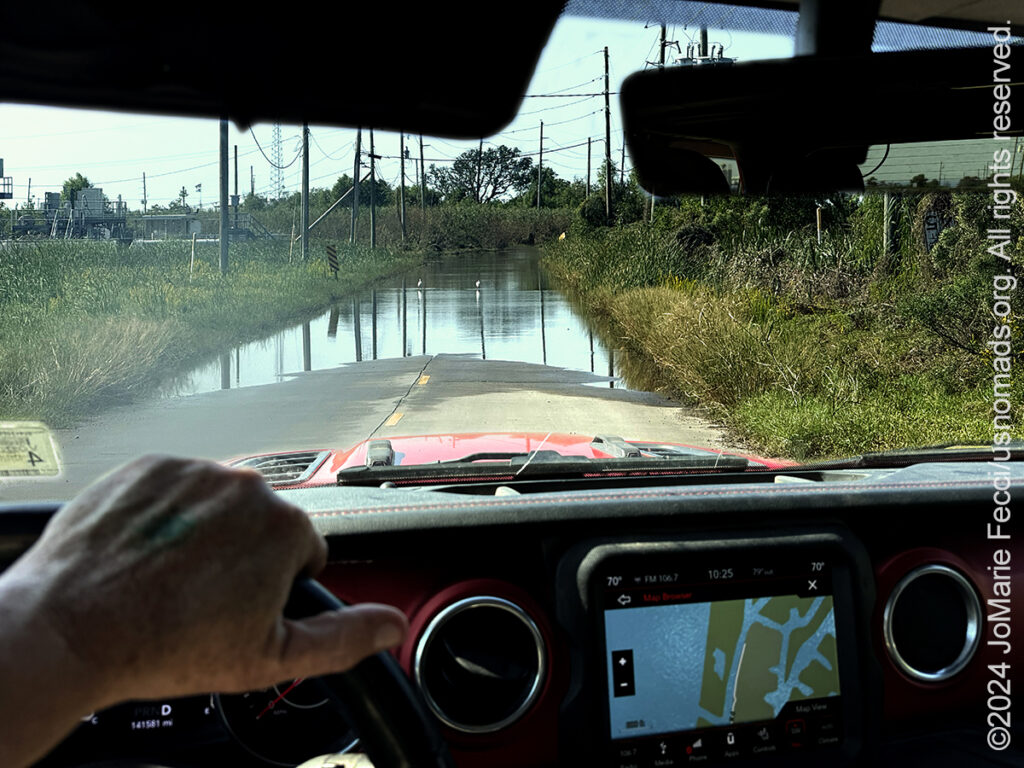
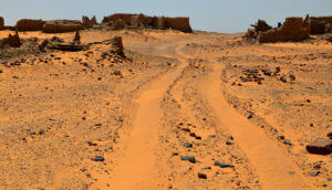
14 October 2024: We decided to try to reach the Gulf of Mexico by driving along the bank of the Mississippi River along Louisiana State Highway 23, which on a map looks like it goes all the way into the gulf, ending on the tip of a finger of land. I had imagined we would be able to see the river and the commercial ship traffic along the way. I was wrong. The system of “levees” that protect the population from flooding in these delta communities is actually large dirt berms build up around the river’s banks to create a barrier to flood water (like making a giant earthen “bowl” for the river to fill when it floods, without going over it’s edges into the inhabited areas). The dirt berms are planted with grass on the sides and that is all we can see! Walls of grass. We could see from the GPS that the river was “right there” but we couldn’t actually see it. Finally as we reached the southern most tip of the “finger” the levees disappeared and we were surrounded by a swiss cheese like jumble of land and water — the wetlands. Alligators, herons, egrets, cormorants and lots of other wildlife were suddenly in abundance. Sprinkled in between were commercial fishing boats (mostly shrimp boats) and larger ships as well as oil refineries and other peripherals of the offshore oil industry. We continued on HWY23 until the road just disappeared under water. I was unsure if it was just a big puddle or if this was where the road ended. Despite the fact that my GPS said the road continued a little further, the presence of wading birds in the water on the road, and the lack of any signs of recent traversing made me decide that this WAS the “end of the road” and it was time to turn around. On the way back up the peninsula, we decided to stop at the site of Fort Jackson, where we discovered we COULD drive on the levees and actually SEE the river …
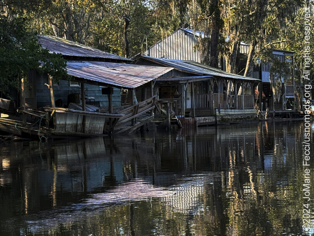
13 October 2024: We settled into camp at the Fontainebleau State Park right on the edge of the big lake, then set out to explore the nearby Honey Island Swamp. The “swamp” is actually part of the Pearl River, and Honey Island is called that because of the many Tupuelo trees that were a plentiful source of honey back in the day. In those days these swamps, bayous and rivers were the main transportation route, and there were no “roads” (and we would learn that even today to explore deep in the back country you need to go on water). Homes faced the water, and people got around by various types of boats. Today these properties still exist and are used as hunting and fishing “camps” by descendants of the original owners. There are only a limited number of these properties as the rest of the wetlands are now protected, and so if someone wants to buy one, they have to wait for someone willing to “sell,” and in effect they are hard to come by. This is despite the fact that they cannot be insured, and when damaged by the frequent storms the people are on their own to repair or rebuild, which results in many of the camps being in various stages of ruin for the time it takes the owners to be able to afford repairs…
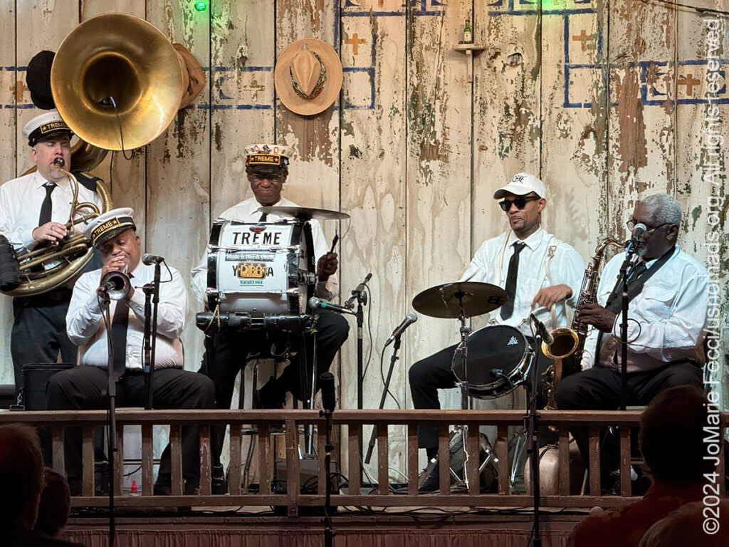
12 October 2024: In the morning there was “smoke” on the water and it definitely exuded that swamp-ish character we were in search of. A little bit of exploring took us to a cypress stand around another bend of the trail. We got back on the road towards Louisiana, but took a “scenic route” following the Natchez Trace. The Natchez Trace was an old route that was used back in the day of horses and carriages, and it followed an even older Indian footpath (in fact there are several Mississipian Mounds along the Trace). The route is a paved road through forest land with “stops” of scenic or historical significance — often times at the sites of what were once called “stands” which were basically inns, or “caravanserais,” placed a days travel apart along the way. Mostly there is nothing left of these “stands” but at one spot we came across some graves dating from the 1800s scattered around a hiking trail deep in the woods. Eventually we found our way to the Windsor Ruins, a series of ornate columns rising up in the middle of nowhere surrounded by forest and not much else. These ruins are all that is left of an elaborate plantation building that had burned down. The whole area has been reclaimed by nature and it is hard to believe that these forested lands were once a cotton plantation. Seeing it like this we can get a sense of the immense work involved in clearing and preparing the land for cultivation, all that had to be done by the enslaved before they could even start growing the cotton. Today the area of the “ruins” is cleared and maintained but the surrounding lands have been given back to nature. After exploring the ruins, we got back on the road south into Louisiana, getting into Mandeville on the Northshore of Lake Pontchartrain in time to catch the Treme Brass Band playing at the Dew Drop Jazz and Social Hall — the prefect “Welcome to Louisiana” …
11 October 2024: Leaving Clarksdale we continued to weave between the cotton fields and the difficult history of slavery and it’s impact on people and places in the area we are traveling through during this journey. The region is still scarred with poverty and while our route is focused on the backcountry and wilderness areas, we can’t forget the larger human history intertwined with the land. We made our way to the outskirts of Jackson where we set up camp at LeFleurs Bluff State Park, right on the edge of a body of water that had a very “swamp-like” feel with a white egret perched on a log in the clearing just as the sun was getting ready to set…
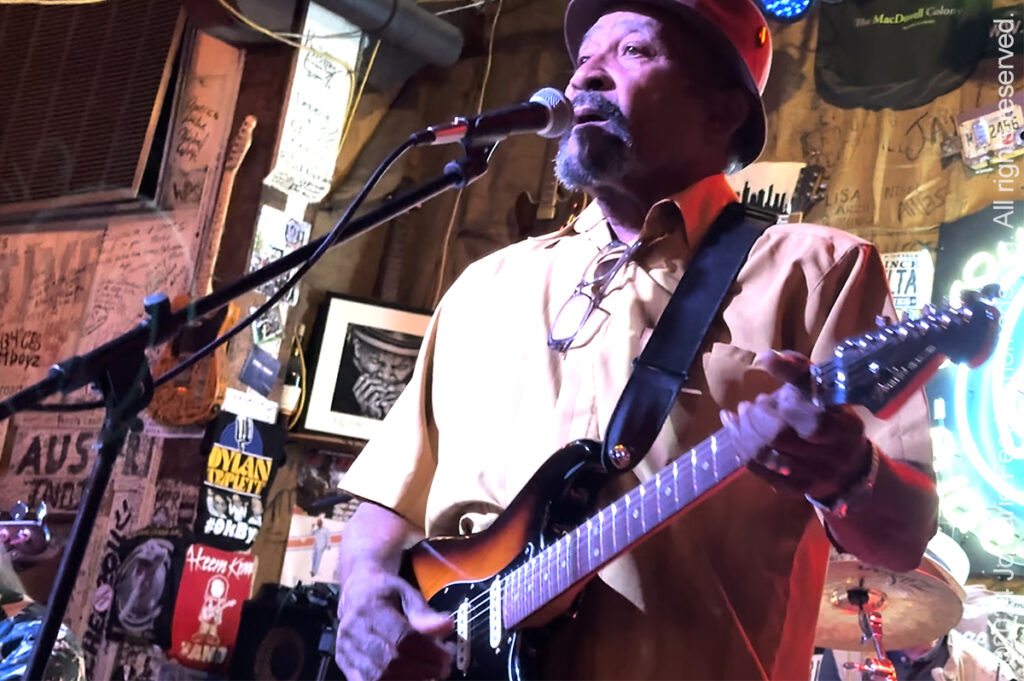
10 October 2024: In the morning we drove right up to the edge of the Mississippi River near Tunica Mississippi, and just spend some time watching the river traffic. Though we think of the river in it’s historical sense as a hub of transport with paddle steamers going up and down, the Mississippi is still a major transport artery with less picturesque barges being pushed by tugboats moving mostly commodities more efficiently than rail transport could. Speaking of commodities, everywhere we looked we passed cotton fields. Though I had thought this kind of cotton production had ended in America with the end of the share-cropping era, I soon realized I was wrong. Cotton cultivation is still very prevalent, even if it is no longer “king.” We were driving along US Highway 61, the “Blues Highway,” and stopped to explore the “Crossroads”– the famed intersection where legend says Robert Johnson made his “deal with the devil.” Clarksdale promotes itself as the town where you can hear the blues live 365 days a year, and so we stopped to check out some modern day blues bands at the Ground Zero Blues Club. We caught a jam night with local musicians and some guests from around the world as well as some young people who kind of combined a poetry slam with the blues soundtrack. The highlight of the evening was when one of the “elders” took the stage and the jam really got hot …
9 October 2024: Continued the drive westward today, going from Kentucky into western Tennessee, where the story of cotton begins. Stopped at the West Tennessee Delta Heritage Center for an introduction to the region, the history of cotton and the origins of that uniquely American form of music–the blues–and it’s connection to it’s African roots (the Heritage Center also includes a small Tina Turner museum at the site of her first school). From there we made a short detour to the Hatchie River National Wildlife Refuge, where we saw the first cypress swamp terrain of the trip, a sign that we had crossed into “the south” for sure …
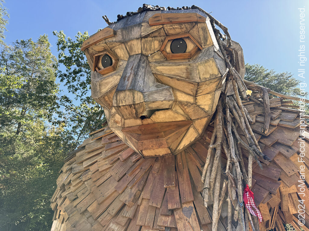
8 October 2024: Took some time in Kentucky to go looking for “trolls,” the giant wooden sculptures by Thomas Dambo that are hidden along woodland trails around the world. The Bernheim Forest has three of the sculptures which can be found on “the Trail of Giants,” a nice hike through several different ecosystems with the “Giants” thoughtfully placed within the environment …
THIS MONTH:
![]()
Roadtrip time! Heading south in search of the history of the Mississippi Delta region, with a focus on Louisiana and the different styles of music that evolved there as different cultures came together “back in the day.” Of course we will also be exploring some of the backcountry and enjoying the outdoors along the way…
![]()
Making a quick stop at Overland Expo East. Overland Expo EAST is located in the heart of the Blue Ridge Mountains near George Washington & Jefferson National Forests, and Shenandoah National Park and runs from Friday October 4th to Sunday October 6th. No other event features a gathering of so many overland legends, authors, and experts. Overland Expo EAST offers more than 300 session-hours of incredible programs—that’s 150+ different classes, slideshows, demonstrations, and activities—brought to you by 100+ instructors and presenters from around the world…
COMING UP SOON:
![]()
USnomads.org is very proud to be presenting the fourth edition of the Nomad Overland Virtual Adventure Rally in 2025. This is a unique kind of rally experience — a ten week event that participants can do from anywhere within the continental U.S.A. Competitors design their own routes as part of the rally, then drive it in a points-based online competition that includes optional activity tasks, quests and weekly challenges. The 2025 rally will run from 2 June – 10 August and is open to any driver within the United States who has an off-road capable vehicle — stock or modified. Registration for 2024 is currently open. For more information see the Rally website …
CLARKSDALE’S CROSSROADS
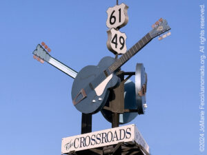
Clarksdale Mississippi is known as the birthplace of the blues and home to the Crossroads where, according to legend, the great bluesman Robert Johnson sold his soul to the devil in exchange for supernatural musical ability. Today, a monument featuring three giant blue guitars marks the intersections where this event was said to have happened. Robert Johnson was born and raised in the Mississippi Delta and began playing guitar in the 1920’s. Today he is recognized as one of the most important innovators of the Delta blues. Many fascinating legends surround his music and history, the most prominent being his encounter with the Devil at the “crossroads.” The story goes that Johnson was a horrible guitar player when he first started playing. Then after disappearing from the music scene for a year or so, he came back as an innovative master. Legend recounts that Johnson’s new found skill was the result of his encounter with the devil at a dark and deserted crossroads around midnight. The devil appeared as a strange man who took Johnson’s guitar, tuned it and played a few songs before returning it to Johnson. Ever after, people were amazed at Johnson’s unique and novel techniques and unusual voicing. Blues aficionados are fortunate that Johnson recorded 29 songs in Texas a few years before his death, including “Me and the Devil Blues” and “Crossroad Blues.” His legacy has influenced great bluesmen like Muddy Waters, Eric Clapton, and the Rolling Stones. The actual location of “The Crossroads” is of course in dispute. Some claim it is at the intersection of Highways 8 and 1 south of Rosedale. Others say it was at Dockery Plantation, near Clarksdale. Clarksdale, the birthplace of the blues, lays claim to the location of Highways 61 and 49 and has staked that claim with the giant guitar sign. Highway 61 is known as the “blues highway” and Highway 49 is the road to Parchman Prison, inspiration for many blues songs…
KING COTTON

Cotton began to become an increasingly desirable crop in the 1790s as Americas oldest crops, like tobacco, were depleting farmland and dropping in value. At the same time, the textile industry in Great Britain was exploding, creating enormous international demand for cotton clothing. Many stakeholders benefited from the cotton economy — plantation owners in the South, banks in the North, shipping merchants, and the textile industry in Great Britain. Cotton transformed the United States, making fertile land in the Deep South, from Georgia to Texas, extraordinarily valuable. Because of British demand, cotton was vital to the American economy. Cotton accounted for over half of all American exports during the first half of the 19th century. The cotton market supported America’s ability to borrow money from abroad. It also fostered an enormous domestic trade in agricultural products from the West and manufactured goods from the East. In short, cotton helped tie the country together. Mississippi was the epicenter of the cotton production phenomenon during the first half of the 19th century. Mississippi and its neighbors – Alabama, western Georgia, Louisiana, Arkansas, and Texas – provided the cheap land that was suitable for cotton production. Cotton provoked a “gold rush” by attracting thousands of White men from the North and from older slave states along the Atlantic coast who came to make a quick fortune. Enslaved people were transported in a massive forced migration over land and by sea from the older slave states to the newer cotton states. To feed “King Cotton,” more than a million African Americans were carried off into the Deep South. Mississippi’s social and economic histories in early statehood were driven by cotton and slave labor, and the two became intertwined in America. Cotton was a labor-intensive business, and the large number of workers required to grow and harvest cotton came from slave labor until the end of the American Civil War. After the Civil War, the sharecropping system that replaced slavery and cotton productivity remained central to the American economy for a long time — Cotton was the leading American export from 1803 to 1937. Changes in cotton production developed out of the Great Depression and accelerated during World War II when many former sharecroppers left Mississippi and sought employment in northern factories. At the same time, cotton was in high demand. This dichotomy resulted in perhaps the greatest advancement in cotton agricultural technology since Whitney’s cotton gin: the first effective mechanical cotton picker, developed by International Harvester in 1947. Within two decades virtually all of Mississippi’s cotton sharecroppers were gone. During the second half of the twentieth century many Mississippi planters and farmers moved away from cotton production and toward other row crops such as soybeans and corn as well as highly commercialized catfish and poultry operations. Cotton has recently ranked third, behind poultry and forestry, among Mississippi’s leading forms of agriculture. Today, approximately 1.1 million acres are planted to cotton in Mississippi, depending on a number of factors, including weather, price, and commodity markets…
THE GIANT TROLLS
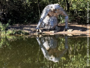
Artist Thomas Dambo is known for creating colossal 15- to 21-foot-tall giants that he hides in parks and greenspaces around the world. Since 2014, Dambo has erected dozens of the wooden, folklore-inspired creatures made from scrap materials found wherever they are built. His website has a map of Troll coordinates that can conjure an globe-trotting scavenger hunt for the whimsical sculptures. Three of Dambo’s Trolls live in the Bernheim Forest in Kentucky, where they delight visitors young and old. Taking the “Forest Giants Trail” through the park, the first Troll you meet is “Little Nis” who gazes into the waters of Holly Pond looking at his own reflection. A bit further along the trail you will find his mother, Momma Loumari resting against a redwood tree. And at the end of the trail, Little Elina, reclines in a field welcoming visitors to join her. Dambo used wood from recycled pallets and Bourbon barrel staves to construct the Kentucky Trolls. Dambo was commissioned to create the giants as part of the Bernheim Forest’s 90th anniversary in 2019…
Nesconset | Paris | Belgrade | Arrington | Mandeville | New Orleans

MORE NOTES FROM THE ROAD:
1-7 October – Roadtrip South
September – New York
August – New York
26-31 March – Eastbound
20-25 March – NM
15-19 March – DVE
9-14 March – AZ
1-8 March – NV & AZ
23-29 February – Glamis
16-22 February – Roadtrip SW
1-15 February – Roadtrip SW
January – Paris
22-31 December – Holiday Roadtrip
15-21 December – Holiday Roadtrip
1-14 December – Holiday Roadtrip
8-30 November – New Jersey
1-7 November – Cape Cod
27-31 October – Cape Cod
16-26 October – Long Island
1-15 October – Roadtrip East
23-30 September – Roadtrip East
16-22 September – Colorado
8-15 September – Moab LONCON
1-7 September – Roadtrip West
Archive
ROADTRIP

An epic journey crisscrossing the USA from east to west and back again, exploring some of the beautiful wild spaces that make up our “public lands.” The roadtrip covered almost 15,000 miles, much of it off-grid and off-pavement, focusing on the deserts of the American southwest. Some locations were truly “iconic” while others were little known, and the segments of independent exploration where punctuated with some fun events across the region… [read]
SPECIAL REPORT
All about exploring ghost towns and abandoned places in the USA and beyond, with tips, and information on the many different types of sites to be found across the globe, including detailed guides for eight specific sites… [read]
REFLECTIONS

EGYPT: CAIRO REFLECTIONS
A quick overview of impressions from a stop in Cairo during our recent scouting mission in Egypt and Sudan … [read]
SPECIAL REPORT

A look into south-eastern Algeria on the border with Libya and Niger: overlanding with the Tuareg in one of the most remote corners of the Sahara … [read]
LOCATION
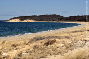
This installment of a series that focuses on locations around the USA takes a look at some favorite places near our home base in NY. We share a few places we like to explore, where you can experience something of the raw natural beauty of coastal beaches, pine barrens and a little bit of obscure military history… [read]