
NOTES FROM THE ROAD
< more recent | 22-31 March 2023 | older >
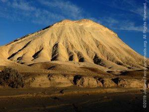
Death Valley: Wind and Snow on the Mountains…
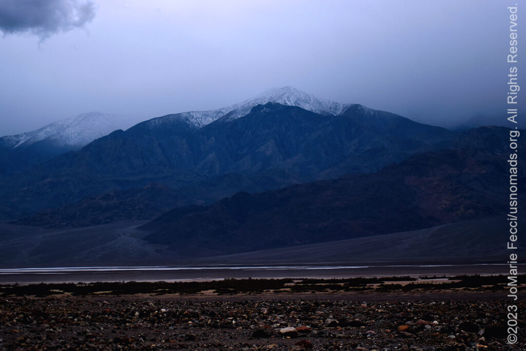
More precipitation threatens trail plans for DVE…
21 March 2023: Arrived to Death Valley and the wind was so strong it destroyed the registration tents that were set up for the Death Valley Experience event. We were literally all holding them down to prevent everything from blowing off into the desert. There had been more snow and the distant mountains had a white crown, which while beautiful, was not a good omen for the Goldpoint route that already had snow blocking it just a week or so ago…
NV: Grapevine Canyon…
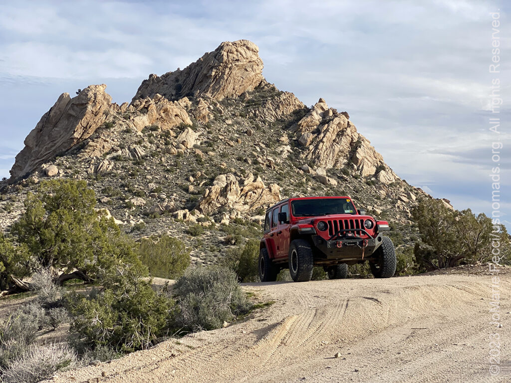
Made a stop at a favorite place…
20 March 2023: Took some time to stop in Nevada and visit Grapevine Canyon and Christmas Tree Pass, a favorite route when in that area. Making a brief visit to the petroglyphs and then just enjoying some solitude in the desert on the edge of the Spirit Mountain wilderness is always energizing …
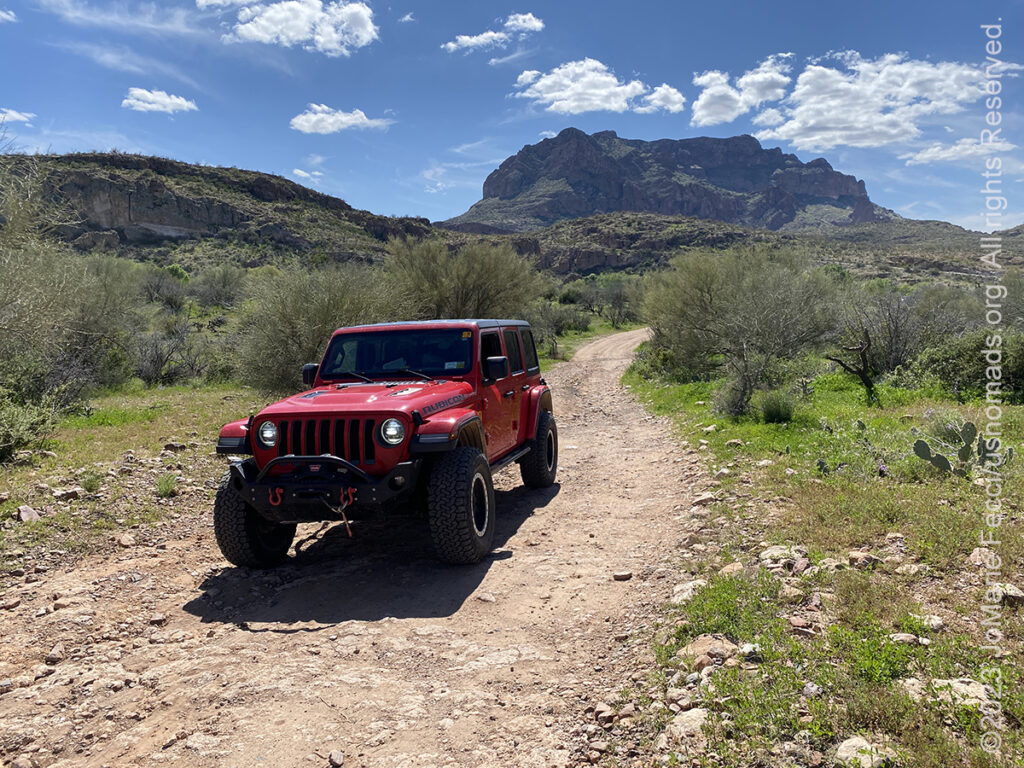
AZ: Tonto Basin with Friends…

Traffic jam on the trail…
19 March 2023: Fun day sharing the trail with good friends out in the Tonto Basin area. The impact of the recent wet weather continued to force us to adapt our plans, but with a few small alterations we were still able to check out the trails we had planned on. It was remarkable to see this part of Arizona looking so green. And then there were the cows on the trail, lol…
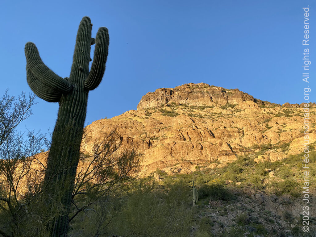
AZ: Exploring around Superior …
Checking out some new trails…
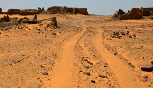
18 March 2023: Went from Bulldog Canyon down to Superior to check out some unfamiliar trails, but had to adapt the plan to account for flooding and washed out trails in some places. The heavy rains have added an element of “surprise” to navigating what are normally easy to follow routes…
AZ: Sedona to Bulldog Canyon …
A pause in the Sonoran desert…
17 March 2023: Left Sedona and set up camp for a few days in the Bulldog Canyon OHV area of the Tonto National Forest. The sun was back out and Arizona was “Arizona-like” once again. Though all the rain had made areas that were usually dry and parched look lush and green…
AZ: Sedona Red Rock Country…
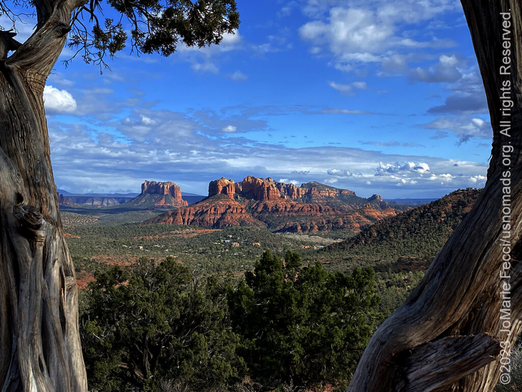
The weather calmed a bit today…
16 March 2023: With the skies clearing a bit, it was a nice day to just enjoy some scenic driving and short walks in some of the beautiful Red Rock areas around Sedona …
AZ: Flooding in the Sedona Area…
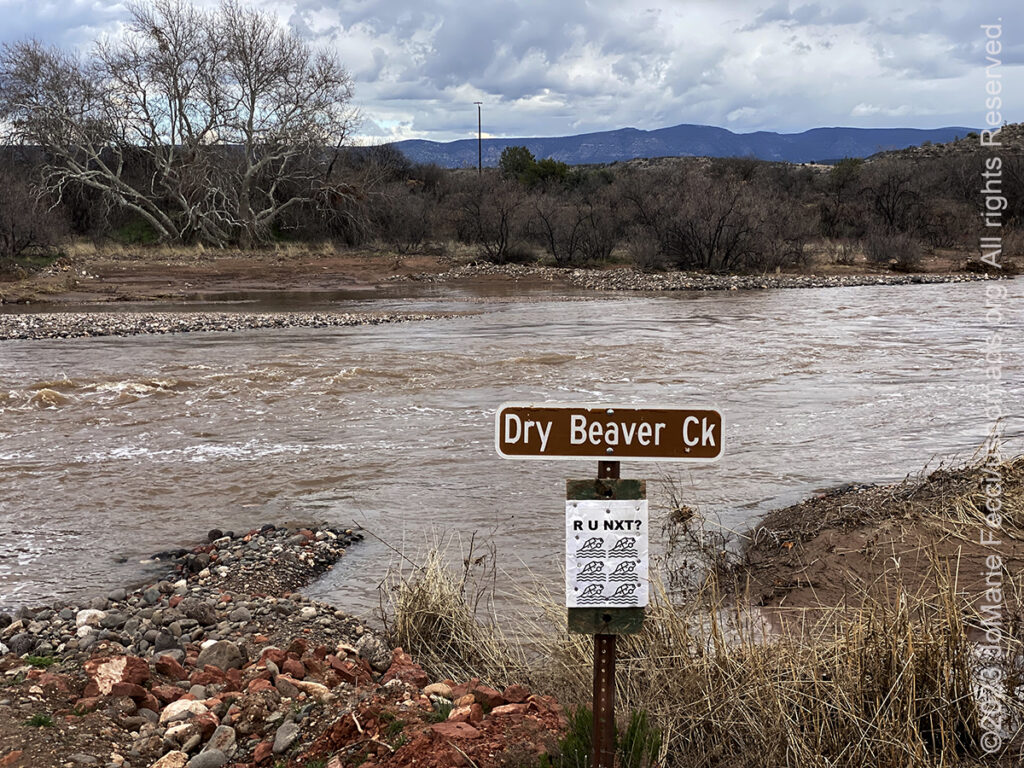
Dry Beaver Creek is running high…
15 March 2023: The rain has mostly stopped but it is still overcast and there is still a lot of flooding and fast moving water in places that are usually dry. Someone put up an ironic addition under the Dry Beaver Creek sign — but the warning is real. These washes can be dangerous to cross when the water is flowing, so definitely a “turn around, don’t drown” scenario …
PREVIOUS NOTES FROM THE ROAD >
THIS MONTH:
Roadtrip time again. Heading southwest and into the desert for some new exploration as well as a few of our favorite events. Lots of details still to be determined, but we’re on our way…
![]()
Joining the Barlow Adventures crew at the Imperial Sand Dunes in southern California to document the training process for a seven-day driving and navigation program focused on moving safely and effectively through the desert…
![]()
Trail Guiding for the California 4-Wheel Drive Association’s second annual Death Valley Experience fundraiser event running March 22-25, 2023. Each day will feature a choice of runs to some famous, some infamous and some secretive points of interest within Death Valley National Park. The runs will depart from Furnace Creek and from Stovepipe Wells. Some of the points of interest we will visit during Death Valley Experience 2023 include Zabriskie Point (famous) and Barker Ranch (infamous) as well as Dante’s View, 20 Mule Team Canyon, Artists’ Drive, Chloride Cliffs, Aguereberry Point, Skidoo and Darwin Falls. All of the trail runs are suitable for novice drivers and SUVs with high clearance and 4-wheel drive…
COMING UP SOON:
![]()
USnomads.org is very proud to be presenting the second edition of the Nomad Overland Virtual Adventure Rally in 2023. This is a new kind of rally experience — a ten week event that participants can do from anywhere within the continental U.S.A. Competitors design their own routes as part of the rally, then drive it in a points-based online competition that includes optional activity tasks, quests and weekly challenges. The 2023 rally will run from 5 June – 13 August and is open to any driver within the United States who has an off-road capable vehicle — stock or modified. Registration for 2023 is open now. For more information see the Rally website …
DEATH VALLEY
Steady drought and record summer heat make Death Valley a land of extremes. Yet, each extreme has a striking contrast. Towering peaks are frosted with winter snow. Rare rainstorms bring vast fields of wildflowers. Lush oases harbor tiny fish and refuge for wildlife and humans. Despite its morbid name, a great diversity of life survives in Death Valley. Death Valley in the northern Mojave Desert, bordering the Great Basin Desert,t is one of the hottest places on Earth. Death Valley’s Badwater Basin is the point of lowest elevation in North America, at 282 feet below sea level, and it is 84.6 miles east-southeast of Mount Whitney, the highest point in the contiguous United States. On the afternoon of July 10, 1913, the United States Weather Bureau recorded a high temperature of 134 °F at Furnace Creek in Death Valley, which stands as the highest ambient air temperature ever recorded at the surface of the Earth. Death Valley runs from north to south between the Amargosa Range on the east and the Panamint Range on the west; the Grapevine Mountains and the Owlshead Mountains form its northern and southern boundaries, respectively. Death Valley is technically a “graben”-—a downdropped block of land between two mountain ranges. The valley is extremely dry, because it lies in the rain shadow of four major mountain ranges (including the Sierra Nevada and Panamint Range). Moisture moving inland from the Pacific Ocean must pass eastward over the mountains to reach Death Valley; as air masses are forced upward by each range, they cool and moisture condenses, to fall as rain or snow on the western slopes. When the air masses reach Death Valley, most of the moisture has already been lost and there is little left to fall as precipitation. …
NAMING DEATH VALLEY
Death Valley’s name is a legacy of the “Lost ’49-ers,” a group of prospectors on their way to the California Gold Rush that got stuck in this harsh desert environment. The group was part of the mass of fortune hunters making their way west after gold was discovered at Sutter’s Mill in California in 1848. One of the supply points along the trail was Salt Lake City, where pioneers prepared for the long journey across the Great Basin desert before climbing over the Sierra Nevada to the gold fields of California. It was important to leave Salt Lake City and cross the desert before snow began to fall on the Sierra Nevada, making them impassible. Only a couple of years before, a group of pioneers called the Donner Party was trapped by a storm, an event that became one of the greatest human disasters of that day and age. The fate of the Donner Party was fresh on everyone’s mind when a group of wagons began their journey from Salt Lake City in October of 1849 — much too late to try to cross the Sierra Nevada safely. The group had heard about “the Old Spanish Trail,” a route that went around the south end of the Sierra Nevada and was safe to travel in the winter. The problems were that no pioneer wagon trains had traversed it and they could only find one person in town who knew the route and would agree to lead them. The going was slower than most of the travelers wanted, but the group’s guide, Captain Jefferson Hunt, would only go as fast as the slowest wagon in the group. Just as the people were about to voice their dissent, a young man rode into camp and showed some of the people a hand-sketched map that showed a fictitous “short cut” across the desert to a place called Walker Pass. Everyone agreed that this would cut off 500 miles from their journey so most of the 107 wagons decided to follow this purported short cut while the other wagons continued along the Old Spanish Trail with Captain Hunt. Almost as soon as these people began their journey, they found themselves confronted with an obstacle, a gaping canyon on the present day Utah-Nevada state line. Most of the people became discouraged and turned back to join Captian Hunt, but more than 20 wagons decided to continue on. It was a tedious chore getting the wagons around the canyon and took several days. Despite the fact that the group didn’t have a reliable map, they decided to continue on thinking that all they had to do was go west and they would eventually find the pass. At Groom Lake they got into a dispute on which way to go. One group—-the Bennett-Arcan party—-wanted to head south toward the distant, snow-clad Mt. Charleston in hopes of finding a good water source. The other group—-the Jayhawkers—-wanted to stay with the original plan of traveling west. The group eventually split and went their separate ways. They entered the valley by way of present day Death Valley Junction and along the same route followed by Highway 190. The lost ’49ers had now been traveling across the desert for over two months. Their oxen were weak from lack of forage and their wagons were battered and in poor shape. They too were weary and discouraged but their worst problem was not the valley that lay before them. It was the towering Panamint Mountains that stood like an impenetrable wall as far as could be seen. From Furnace Creek, the routes of the two groups diverged. The Jayhawkers (including the Brier family) went north toward the Mesquite Flat Sand Dunes where they decided they would have to leave their wagons and belongings behind and walk. They slaughtered several oxen and used the wood of their wagons to cook the meat and make jerky. After crossing the Panamint Mountains via Towne Pass and dropping down into Panamint Valley, most of them turned south, making their way into Indian Wells Valley near the present day city of Ridgecrest. Meanwhile, the Bennett-Arcan party struggled across the salt flats and attempted to pass over the Panamint Range via Warm Springs Canyon, but were unable to do so. They retreated to the valley floor and sent two young men, William Lewis Manly and John Rogers, ‘over the mountain’ to get supplies, thinking the Panamint Range was the Sierra Nevada. When Manly and Rogers finally arrived back to the camp of the Bennett-Arcan party they found many of the group had left to find their own way out of the valley. As they finally made their way west over the mountains, one of the prospectors turned back to look at the valley below and proclaimed “Goodbye, Death Valley,” giving the valley its name …

MORE NOTES FROM THE ROAD:
15-21 March – Arizona
8-14 March – Joshua Tree
1-7 March – Glamis
20-28 February – Southwest Roadtrip
1-19 February – Woman and Machine
January – Woman and Machine
22-31 December – Holiday Roadtrip
16-21 December – Holiday Roadtrip
1-15 December – Long Island
November – Long Island
22-31 October – Roadtrip East
15-21 October – Moab LONCON
8-14 October – Moab LONCON
1-7 October – Roadtrip West
22-30 September – Roadtrip West
16-21 September – Roadtrip West
1-15 September – Long Island
August – Long Island
15-31 July – Serbia
1-14 July – NE Roadtrip
16-30 June – NE Roadtrip
1-15 June – Long Island
May – Nomad Rally Prep
16-30 April – Long Island
7-15 April – Heading Back to NY
1-6 April – Heading Back to NY
Archive
SPECIAL REPORT
All about exploring ghost towns and abandoned places in the USA and beyond, with tips, and information on the many different types of sites to be found across the globe, including detailed guides for eight specific sites… [read]
REFLECTIONS

EGYPT: CAIRO REFLECTIONS
A quick overview of impressions from a stop in Cairo during our recent scouting mission in Egypt and Sudan … [read]
SPECIAL REPORT

A look into south-eastern Algeria on the border with Libya and Niger: overlanding with the Tuareg in one of the most remote corners of the Sahara … [read]