
< more recent | 15-22 October 2024 | older >
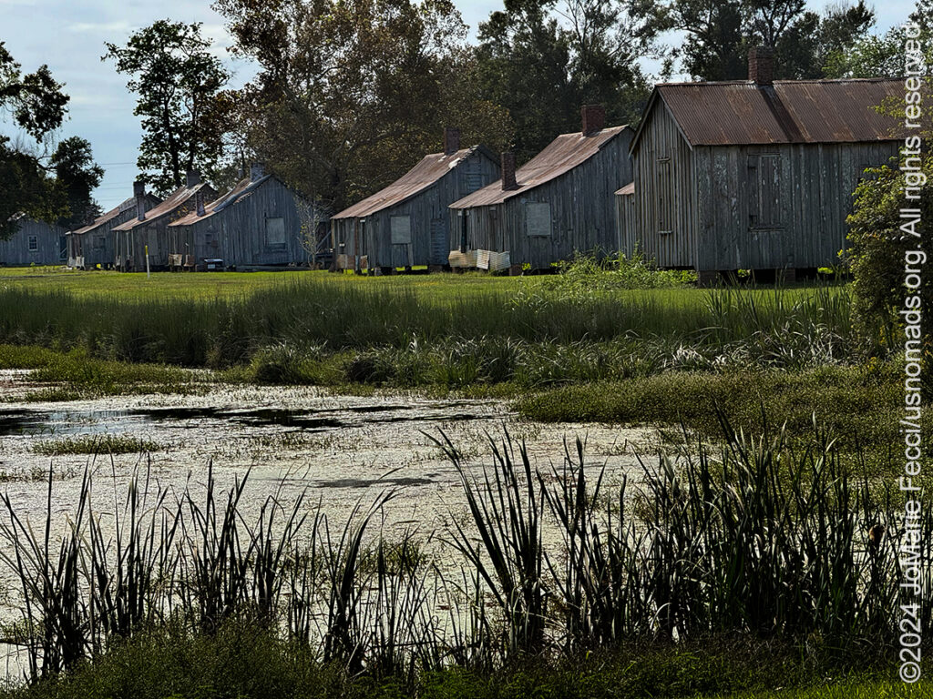
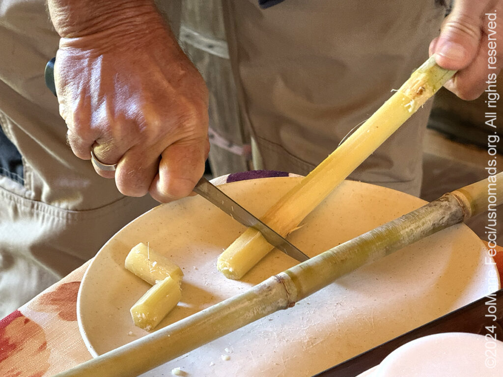
22 October 2024: Following up on my plan to learn more about the sugar cane industry, I made a visit to Laurel Valley plantation. There is a “general store” that is actually more of a museum than a store, and a historical association administers and protects the structures of the “ghost town” village. I met up with the historian and one of the interpretive guides to get a solid history lesson in the beginnings of the sugar cane production in this area and how it evolved into the current practices, and I learned a lot about the role sugar played in the region. As we wandered through the well-maintained “ghost town” structures I also learned about the transition from slavery to share cropping and tenant farming to modern times and the mechanized production of sugar today …
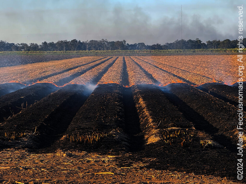
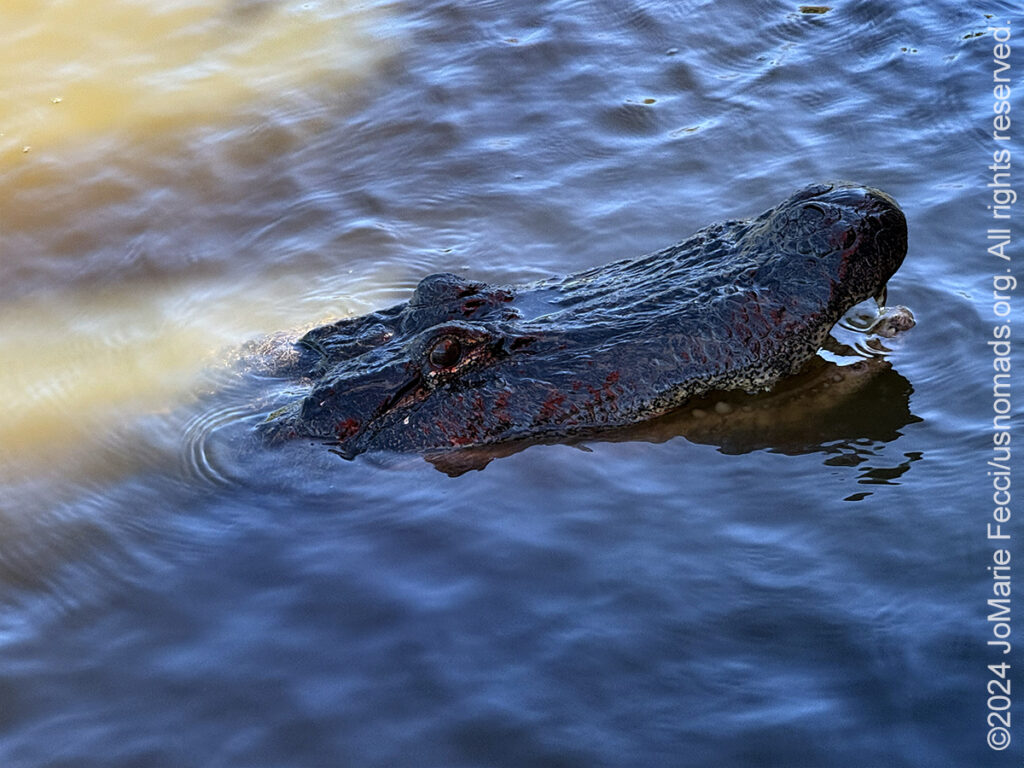
21 October 2024: Last night as I was driving back to camp from Port Fourchon it got dark and I could see the cane fields burning in the distance and it was eerie. This morning I decided I wanted to learn more about the whole sugar cane history in the area and made some plans to explore further. Then I just took some time out to enjoy camp, lazing out on my little dock watching the alligators in the river. There were two who must have their “nest” somewhere near my camp because every afternoon just before sunset they come over and play “hide-n-seek” with me between the cypress roots and the water’s edge, as if they are ready to go home, but don’t want me to see exactly where they go. It was a beautiful and relaxed afternoon after several days of intense activity and it just felt good to be able to appreciate the place I was in …
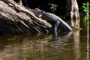
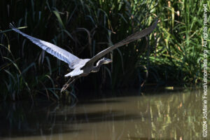
20 October 2024: Lake Fausse Pointe is in the middle of the wetlands area that includes the Atchafalaya Basin, one of the largest and most distinct wilderness areas in Louisiana, and this morning we decided to go check it out in an air boat — a unique type of watercraft that has what looks like a giant “fan” in the back and is propelled by an engine of the kind we have in our cars. The air boat is capable of going where no other watercraft can, because it rides on top of the surface, so even if there isn’t water it can still go. In fact we went through some areas of the swamp that were really just mud tracks, more like jeep trails than water trails. The boat was piloted by a local Cajun resident who’s family has a long history in the area, and he took us into some remote areas of the swamp after crossing the large open “lake” filled with the weathered stumps of ancient cypress trees that had been cut down during early logging in the area. It was like speeding through a “ghost forest” before we reached the narrower channels to look for wildlife. He was looking for big alligators, and he found them — a large mail and several females all hanging out “together.” We also got to see many different types of birds including pink ones known as Roseate Spoonbills that are native to this area. Later on, in the afternoon I decided to drive down LA-1 all the way to the “end” as I had been told you can see the Gulf of Mexico and the offshore oil rigs from Fourchon, the port town located at the “end of the road.” I stopped for lunch about halfway down, at the Amelia Belle casino, an old steamboat permanently docked and turned into a gambling palace. Then continued on the rest of the way to Fourchon where I once again found the collage of marsh-like wetlands that make up a swiss-cheese landscape of water and land. Before crossing the causeway that would take me to the port, I stopped to explore a little of the marshland and went out on a dock where some people were fishing and I saw dolphins playing in the water — that was a surprise. Once I made it to the port town itself, the road really did end, and I made a few photographs of the offshore oil platforms in the distance and some of the big ships in port before turning back. I was satisfied with the day even though I still haven’t found the “edge” of the land that makes up the Gulf coast…
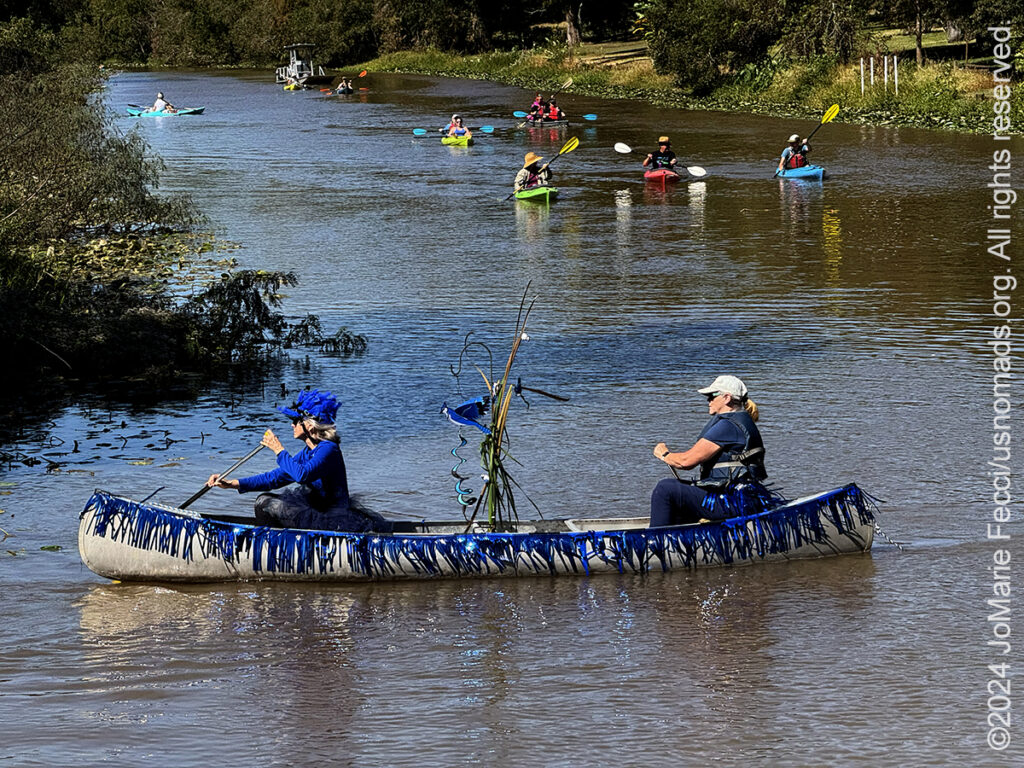
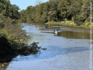
19 October 2024: Started the day with a drive out to Avery Island, the home of Tobasco sauce, where we were able to visit the factory and grounds and learn about the development of the iconic hot sauce and see how it is produced and evolved from locally sourced materials — the island is on a “salt dome” and the salt that is used in the production of the sauce is mined there, the specific peppers for the original recipe are grown there, the whole process still all happens only in this location. The Tabasco company also owns the surrounding lands on the island, and opens part of them to the public in a beautiful park that began as a wildlife sanctuary for birds — notably the snowy egret which was almost hunted to extinction for it’s feathers which were used in fashionable women’s hats back in the day. Did the “wildlife drive” and stopped for some short walks in a few of the more interesting spots before getting back “on the road” towards Breaux Bridge and the Bayou Teche where we joined the “Shake Your Trailfeathers” Paddle Parade event. The “parade” was a roughly 4-mile paddle down the bayou accompanied by barges of musicians playing Cajun music for ambiance, and it ended at the take out point near a park where there were food trucks and more live music throughout the afternoon. The whole thing was a fundraiser for TECHE project, the group that maintains the paddle trails and takes on stewardship projects along this bayou. It was a lot of fun and a great way to enjoy a Saturday afternoon…
18 October 2024: In the morning we joined the Rangers from the Jean Lafitte National Historic Park Wetlands Acadian Cultural Center to do some exploring on the Bayou Lafourche itself. This bayou is less wild, as it was until recently utilized for more commercial traffic, and we can see that some businesses had one face on the water. In fact a lot of these buildings were on top of the old levee. We took the motorized skiff up river to the site of an old sugar plantation. This whole area is full of sugar fields still. It remains an important industry in this part of Louisiana, and at the moment the cane is high and planters are harvesting it everywhere, using a mechanized system to chop the cane and truck it off to the few remaining local refineries. The plantation we visited was once the homestead of US Supreme Court Justice Edward Douglas White, who served on the court for 27 years and was one of the justices who sided with the majority in the historic Plessy v. Ferguson case that established the constitutionality of “separate but equal” segregation in the south. After the spending the morning on the bayou with the Rangers, we headed to Lake Fausse Pointe State Park to set up our second “base camp” right on the bank of a little bayou. It was a fantastic camp site each bayou-side site had it’s own little wooden fishing dock which made for an excellent place to sit out in the late afternoon and watch the transition of day to night (we didn’t get a “sunset” because of the trees all around, but we did get the colorful sky reflecting in the water just before nightfall) …
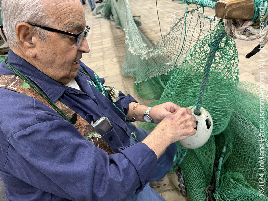
17 October 2024: Broke camp at Fontainebleau State Park this morning and left the Northshore heading southwest to Thibodaux and the Bayou Lafourche which once upon a time was the main course of the Mississipi River down into the Gulf. This is “cajun country” and we headed down LA-1 which parallels the bayou to visit Mr. Chine, a traditional shrimp net maker who still maintains the old way of handcrafting the nets. He also produces other larger nets that are now used to dredge the oil fields to remove 100 years worth of “debris” that litters the floor of the Gulf…
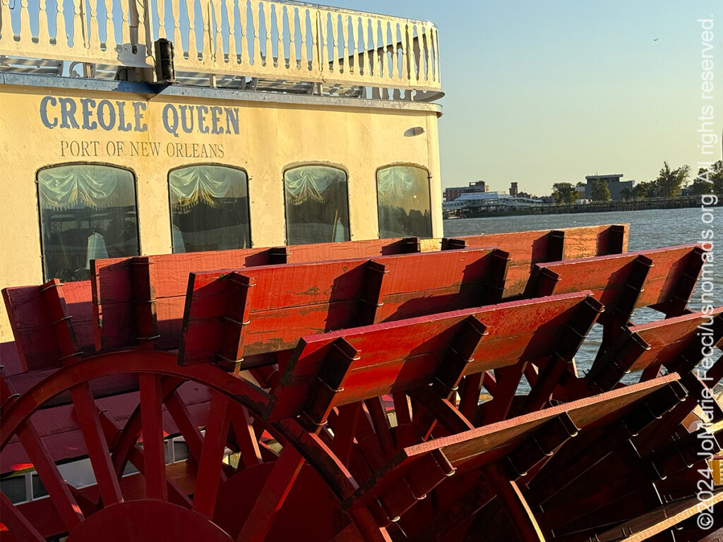
16 October 2024: This morning I decided to brave the urban traffic and at least go into New Orleans French Quarter for a little while to try to see the riverfront. Early in the morning this part of town was still sleepy as the garbage trucks cleaned up the residue from the night and shops slowly began to open for the day. It is probably the only time it is possible to photograph some of these streets without crowds, and the morning light was beautiful on the iron railings of the iconic balconies. But I spent most of my time on the riverfront trying to make a good photo of the old steamboats that now take tourists for jazz cruises to nowhere. The steamboats are the enduring image of the Mississippi River’s “golden age” and I wanted to include them even if I wasn’t actually going on one of the cruises. Meanwhile giant container ships sailed along under the bridge going to or from port, transporting whatever. Proof that the River is still relevant for much more than a tourism economy…
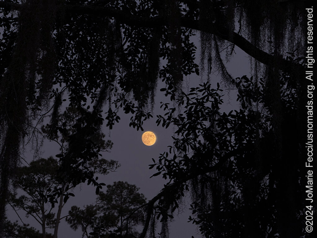
15 October 2024: Took some time to just enjoy being in one place for more than a night and explored a little bit of the Fontainebleau State Park on the shores of Lake Pontchartrain. It is a beautiful park full of stately live oaks with a small sandy strip of beach at the waterfront. The oaks line an area that was once the location of the slave quarters of the sugar plantation that stood here. There is nothing left of the buildings. Like many other places in the south, Louisiana has this historical “void” when it comes to the artifacts of daily life of the enslaved peoples, but today tries to weave their stories back into the narratives, so while the ruins of the Sugar Mill stand as testimony to the plantation’s existence, only a sign stating that the “slave quarters” were once here, hints at the people who built and labored on it. The sun set below the tree line and the moon rose lighting up the sky in it’s place. It was almost full …
THIS MONTH:
![]()
Roadtrip time! Heading south in search of the history of the Mississippi Delta region, with a focus on Louisiana and the different styles of music that evolved there as different cultures came together “back in the day.” Of course we will also be exploring some of the backcountry and enjoying the outdoors along the way…
COMING UP SOON:

Getting ready for this year’s Holiday Roadtrip south, where we are changing it up a little bit and spending more time on our favorite barrier islands along the Outer Banks as we celebrate the season with plenty of good cheer out on the sand …
Returning to the “city of light” after a way-too-long hiatus and reconnecting with friends, favorite places and some urban exploring to change things up a little bit …
![]()
USnomads.org is very proud to be presenting the fourth edition of the Nomad Overland Virtual Adventure Rally in 2025. This is a unique kind of rally experience — a ten week event that participants can do from anywhere within the continental U.S.A. Competitors design their own routes as part of the rally, then drive it in a points-based online competition that includes optional activity tasks, quests and weekly challenges. The 2025 rally will run from 2 June – 10 August and is open to any driver within the United States who has an off-road capable vehicle — stock or modified. Registration for 2024 is currently open. For more information see the Rally website …
SWAMP VS BAYOU
Bayous are commonly found in the Gulf Coast region of the southern United States, especially in the Mississippi River Delta, though they also exist elsewhere. The word “bayou” comes via Louisiana French and is thought to originate from the Choctaw word “bayuk,” which means “small stream”. Bayous are usually shallow and sometimes heavily wooded. They can be freshwater, saltwater, or a combination of both. This combination is called “brackish water.” These slow-moving marshy waterways are often confused with swamps. However, while swamps are fed by surface or groundwater and may be stagnate or flowing, bayous are the constantly flowing, typically wide and shallow sections of rivers, streams, and other coastal estuaries. Bayous are more specific to the southeastern parts of the United States, especially Louisiana. Most of Louisiana’s “bayous” are actually tributaries of the Mississippi river. The first settlements of the Bayou Têche and other bayous were founded by the Louisiana Creoles, and the bayous are commonly associated with Creole and Cajun culture. Until the 20th century, bayous along the Gulf Coast and Mississippi River were vital for transportation, communication, and commerce. Swamps are wetlands with trees, primarily found in low-lying areas where water collects, and they can be found in many parts of the world. They act as nature’s sponges, absorbing excess rainfall and preventing flooding. Swamps can be freshwater, brackish, or saline, depending on their proximity to the coast and the sources of water they receive. The primary defining characteristic of a swamp is the dense growth of vegetation, including trees like cypress and shrubs. This thick vegetation provides a habitat for various wildlife, from amphibians and reptiles to birds and mammals. The water in swamps is relatively stagnant, causing it to appear murky. The Atchafalaya Basin is the largest river swamp in the United States. While swamps and bayous showcase the beauty and importance of wetlands, they have distinct characteristics that set them apart. The dense, tree-filled expanses of swamps contrast with the bayous’ meandering, channel-like appearance. Yet, both are vital in maintaining ecological balance and offering rich habitats for wildlife. Both swamps and bayous are integral to the ecosystems they inhabit. They act as buffers during storms, absorbing excess water and reducing the impact of floods. Their waters serve as nurseries for many species of fish and shellfish. They also filter pollutants, ensuring that water bodies downstream remain clean…
BAYOU TECHE
Bayou Teche is a 125-mile-long waterway that was the Mississippi River’s main course when it developed a delta about 2,800 to 4,500 years ago. Through a natural process known as deltaic switching, the river’s deposits of silt and sediment caused the Mississippi to change its course, and flow out to the gulf via New Orleans instead. The Teche begins in Port Barre where it draws water from Bayou Courtableau and then flows southward to meet the Lower Atchafalaya River at Patterson. Two major Native American tribes lived along the banks of the Teche for thousands of years before the arrival of Europeans. They were the Chitimacha, who settled along the lower sections of the bayou and still have tribal lands around what is now Charenton, and the Attakapas tribe, which settled along the upper sections of the Bayou from its headwaters around what is now Port Barre to the area now known as St. Martinville. During the 18th-century Acadian migration to the area the Teche was the primary means of transportation. Early economic development of the Atchafalaya Basin hinged on the Bayou Teche. Before roads, the little Teche, not the Atchafalaya, was the highway from the Gulf of Mexico into the heart of Louisiana. The Teche was navigable over 100 miles, yet just wide enough, deep enough and swift enough to maneuver. Several Bayou Teche settlements materialized because of the timber and waterborne economy. The Teche winds its way through four parishes and ends in the Atchafalaya Basin, an essential source of food, timber and fur, a refuge for escaped slaves and a natural resource for enterprising Cajuns and Creoles. Once described as the “most richly storied of the interior waters, and the most opulent,” this body of water was the center of a booming cypress industry in the early 1900s. After the levees were built along the Atachafalaya River in the 1930s, the Teche and the rice farms located along the bayou suffered a drastic reduction in fresh water. The human attempts to control flooding seriously impacted the landscape, but without them, property damage and loss of human life would certainly be greater…
BAYOU LAFOURCHE
Bayou Lafourche is a 106-mile-long bayou that flows into the Gulf of Mexico. It is flanked by Louisiana Highway 1 on the west and Louisiana Highway 308 on the east, and is known as “the longest Main Street in the world.” The name Lafourche, or “the fork” in French, alludes to the bayou’s large outflow of Mississippi River water. Until the early 13th century, the Mississippi River followed a more southerly course on its path to the Gulf of Mexico. The river’s course eventually changed — as the natural result of periodic major flood events — to its present southeasterly course and the older southerly path became “Bayou Lafourche.” The bayou became an important offshoot of the river because it offered a substantial short cut to the Gulf. The first Europeans arrived in the region in the early 16th century and learned about this “short cut” from the indigenous peoples who spoke openly of ‘the fork’ and ‘the bayuk’. But high waters and vegetation often concealed the entrance to the bayou from the river. The search for ‘la fourche’ became an obsession, especially among French explorers. In 1700, Jean-Baptiste le Moyne, Sieur de Bienville, with Louis Juchereau de St. Denis, and Henri de Tonti, finally found ‘la fourche’ and the French became firmly established. After England exiled the French-speaking people from of the Maritimes region of Canada in 1755 many of the Acadias, as they were known, relocated to South Louisiana, settling along the bayou in the early 1800s. The waterway became the central source of transportation and communication with large households lining the channel. Each landowner had the bayou at their front door and took on the responsibility for their section of a bayou levee. Properties measured approximately 600 square feet in width with depths between a mile and a half to three miles. Roads came later and paralleled the course of the bayou…
FONTAINEBLEAU STATE PARK
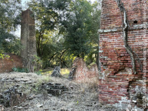
Fontainebleau State Park is located on the north shore of Lake Pontchartrain at the site of what was once a sugar cane plantation owned by Bernard de Marigny, founder of Mandeville. The wealthy Marigny developed this area across the lake from New Orleans and operated a sugar mill that was built in 1829. He named his large holding Fontainebleau after the beautiful forest near Paris, France. In 1840, his son Armand documented the presence of 153 enslaved individuals at the site, including 57 children under the age of ten. The ruins of the sugar mill situated among towering oaks still attests to it’s history. This historic park offers 2,800 acres with beautiful views of Lake Pontchartrain. Established in 1942, and added to the National Register of Historic Places in 1999, it is the most-visited park in Louisiana…
Nesconset | Paris | Belgrade | Carolla | Mandeville | New Orleans

MORE NOTES FROM THE ROAD:
8-14 October – Roadtrip South
1-7 October – Roadtrip South
September – New York
August – New York
26-31 March – Eastbound
20-25 March – NM
15-19 March – DVE
9-14 March – AZ
1-8 March – NV & AZ
23-29 February – Glamis
16-22 February – Roadtrip SW
1-15 February – Roadtrip SW
January – Paris
22-31 December – Holiday Roadtrip
15-21 December – Holiday Roadtrip
1-14 December – Holiday Roadtrip
8-30 November – New Jersey
1-7 November – Cape Cod
27-31 October – Cape Cod
16-26 October – Long Island
Archive
ROADTRIP

An epic journey crisscrossing the USA from east to west and back again, exploring some of the beautiful wild spaces that make up our “public lands.” The roadtrip covered almost 15,000 miles, much of it off-grid and off-pavement, focusing on the deserts of the American southwest. Some locations were truly “iconic” while others were little known, and the segments of independent exploration where punctuated with some fun events across the region… [read]
SPECIAL REPORT
All about exploring ghost towns and abandoned places in the USA and beyond, with tips, and information on the many different types of sites to be found across the globe, including detailed guides for eight specific sites… [read]
REFLECTIONS

EGYPT: CAIRO REFLECTIONS
A quick overview of impressions from a stop in Cairo during our recent scouting mission in Egypt and Sudan … [read]
SPECIAL REPORT

A look into south-eastern Algeria on the border with Libya and Niger: overlanding with the Tuareg in one of the most remote corners of the Sahara … [read]
LOCATION
This installment of a series that focuses on locations around the USA takes a look at some favorite places near our home base in NY. We share a few places we like to explore, where you can experience something of the raw natural beauty of coastal beaches, pine barrens and a little bit of obscure military history… [read]