
< more recent | 15-30 June 2019 | older >
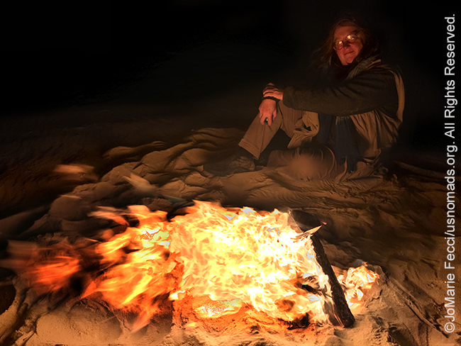
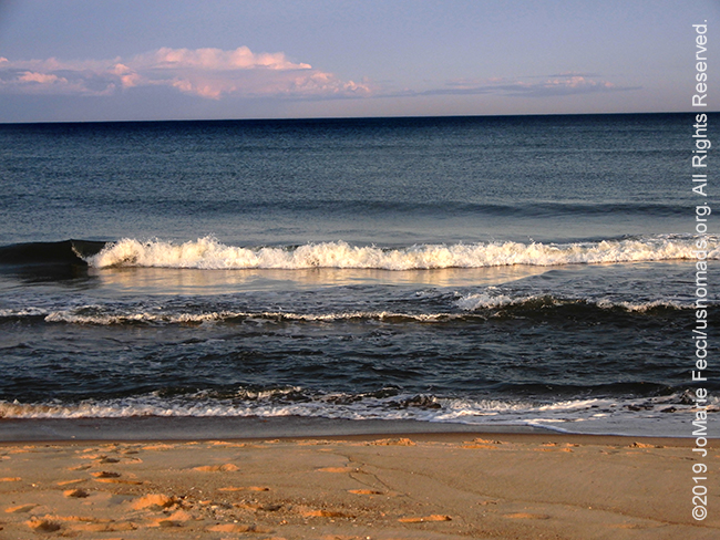
23 June 2019: Ended our day back on the beach at Hither Hills where we struggled to light our campfire with the wind blowing steadily. Eventually we prevailed and had a great campfire under the stars as the sound of the gentle waves crashing onto the beach reminded us how this is all both eternal and ephemeral …
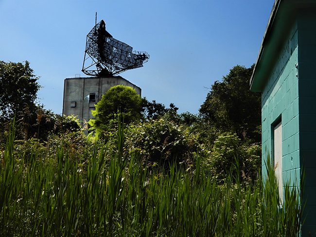
23 June 2019: Took some time to explore around Camp Hero which was once a military outpost and training site but has long since been reclaimed by nature, with just a few empty relics of the past hidden in the woods. The old radar station is the most dramatic, rising up seemingly out of nowhere…
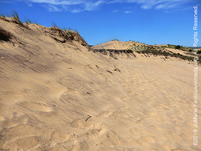
23 June 2019: Beyond the edge of the sandy beach there were woodlands and beyond the woodlands an amazine sand dune landscape that could almost seem desert-like. There was a self-guided discovery hiking route, but crisscrossing trails continued further and it seemed possible to spend an entire day just wandering here…
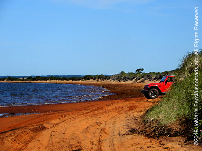
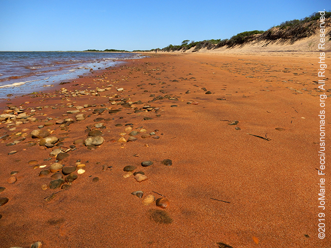
23 June 2019: We found our way onto a thin ribbon of orange colored sand that seemed deserted, though the tire tracks and footprints told us it was clearly well-trafficked. The empty wilderness beach in the early morning was a magnificent discovery and we set out to explore further on foot…
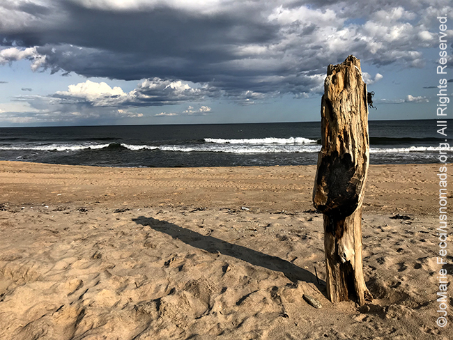
22 June 2019: We managed to get the last campsite available at Hither Hills, a New York State campground that is on the beach in Montauk, and while the campsites themselves are typical State Park developed sites behind the beach dunes, a stretch of the beachfront is accessible to us all day and night, allowing for some amazing opportunities to spend the evening under the stars with the ocean waves crashing on shore just a dozen feet away …
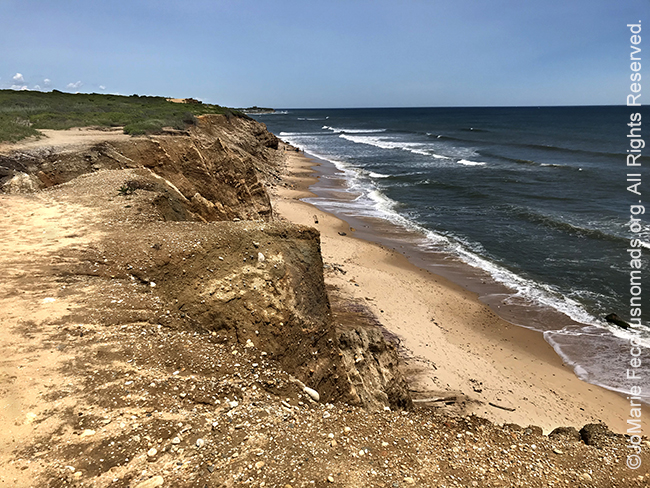
22 June 2019: At the Shadmoor State Preserve there are some beautiful rugged cliffs that face the Atlantic in a dramatic landscape unusual for Long Island. A walk along gentle woodland trails on flat and easy terrain leads to a grassy “edge” that drops straight down to the beach below. Erosion has carved steep craggy edges and from the top the sea itself almost seems “wild” …
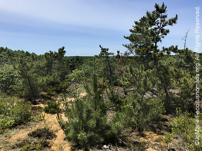
22 June 2019: There are a number of places to hike and explore around the pine barrens, where the landscape remains similar to what the islands first settlers must have experienced. Sandy soil and pine tree forests that go almost right up to the beaches makes for a nice relaxing summer walk in the shade…

22 June 2019: Headed out east for a weekend of exploration and camping on Long Island’s south fork where we took the slow road with a lot of detours to check out some of the area’s natural beauty. We searched out some of the “wilderness” areas that remain in a few hidden pockets of this otherwise very suburban sprawl and we were not disappointed…
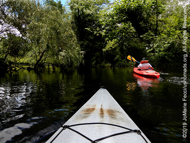
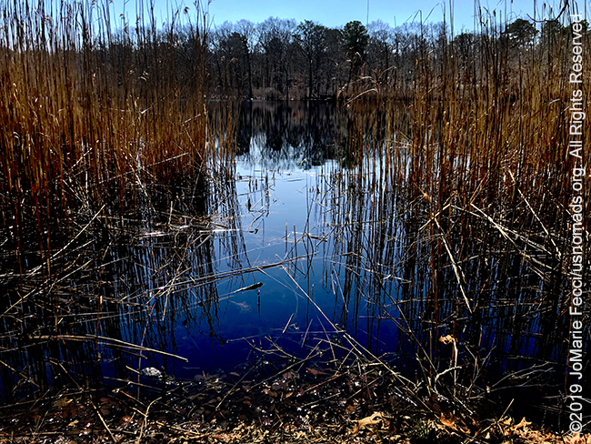
15 June 2019: Great day to get out and do some kayaking on the Nissequoge River, a tidal basin on the north shore of Long Island that offers a great opportunity to paddle through a maze of marshland to the start of the Long Island Sound. Saw one of the Bald Eagles that frequent the area as a bonus…
THIS MONTH:![]()
Participating in this year’s Ladies Offroad Challenge which begins May 13th and continues for ten weeks. Designed by Charlene Bower as a fun way of building skills, the challenges offer something for everyone, and can be as hard or easy as desired — though at least one is designed to push participants outside their comfort zones…
COMING UP SOON:

Joining the ladies at Woman and Machine New England for a day of automotive learning fun focused on cars, engines, welding, and more. This automotive educational and networking event is designed for those who want to understand more about their vehicles and/or explore the skill sets that make up various realms within the automotive industry. The event is open to everyone from seasoned professionals to the wrench-curious ladies who are interested in learning more about cars from other women …
![]()
Attending the Ladies Offroad Network Convention in Atlanta, GA. The 3rd annual convention will be held August 1-4, 2019, with lots of hands-on opportunities to gain all types of offroading skills, learn and engage with other offroad ladies as they share their stories, and laugh the whole way. The convention is an action-packed, interactive 4-day weekend educating, motivating, and guiding offroad ladies…

Heading to a small village in Serbia to help out with the annual plum harvest and spend some time exploring the countryside with friends …
![]()
Back to Pennsylvania Coal Country to guide for the 2019 Women’s Wheeling Day at Rausch Creek Offroad Park hosted by Jeep Girls Rock. The day focuses on learning, enjoying the trails and meeting new friends, and is for all trail levels, from beginners to advanced. Female Guides will be assigned to each group and will encourage those who have never wheeled before as they build confidence out on the trails and learn what their vehicle is capable of (guys are welcomed to attend and ride along with women drivers at this family event) …
ABOUT THE WALKING DUNES TRAIL
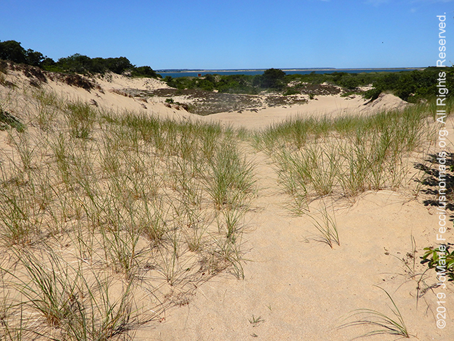
The Walking Dunes trail offers an unusual view of a unique ecological site with something for everyone to enjoy: fascinating land forms, a wide variety of plant communities, animal tracks, and exceptional scenic vistas.The area is made up of three parabolic dunes formed approximately 100 years ago, which are continually shifting (“walking”), swallowing up vegetation as they make their slow progression towards the southeast. The dunes keep moving because the Northwest winds continue to blow sand from nearby headlands to the shore. The Walking Dunes Trail is an easy and enjoyable path along a corridor of sand under a canopy of oaks, beach plum, pitch pine and lovely maritime habitat. The sand dunes roll northwest offering an opportunity to travel upward for panoramic views of Napeague Harbor, Napeague Bay and beyond. The loop continues through an aged cranberry bog, and then back over the sands and onto the beach.
ABOUT NAPEAGUE
Napeague is located on a very narrow, low-lying strip between the Atlantic Ocean to the south and Gardiners Bay to the north that was flooded in the Great Hurricane of 1938. It derives its name from the Montaukett name for “land overflowed by the sea”. At the end of the last ice age, Napeague was submerged under the sea. (At that time, Montauk was an island.) In the intervening several thousand years, ocean currents, or littoral drift, filled in this space with sand, giving rise to Napeague. The Napeague State Park is a mostly undeveloped park stretching across the entire narrow width of the South Fork of Long Island from the Atlantic Ocean to Gardiners Bay and Block Island Sound. It consists mostly of wetlands in areas where waves washed over Long Island during the Great Hurricane of 1938. There is virtually no infrastructure or permitted camping at the park, which is administered by nearby Hither Hills State Park. Its most distinguishing natural feature, a pristine Atlantic Ocean beach, is usually closed during the summer because the endangered piping plover nests near the beach.
HITHER HILLS
Hither Hills State Park has a 189-site campground on the ocean with a pristine sandy beach and plenty of places to explore beyond the shore. There is keen competition for the campsites. To reserve a spot, campers generally must reserve exactly nine months before they hope to arrive and are allowed only one seven-night reservation during the peak season.
SHADMOOR PRESERVE
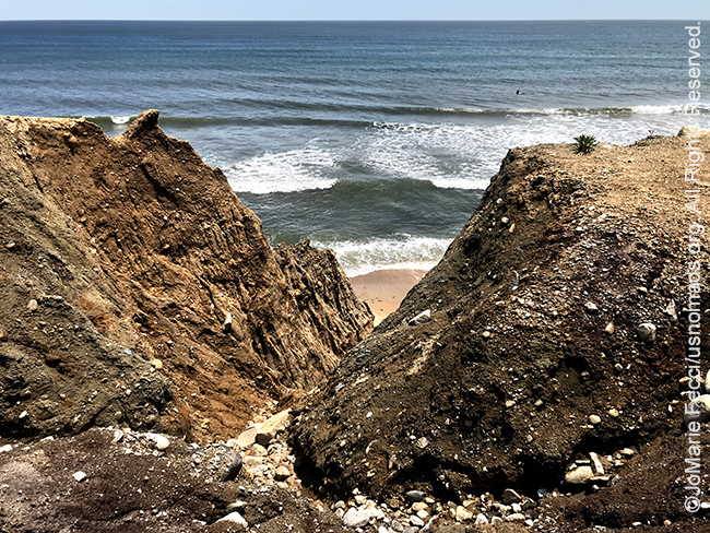
The Shadmoor Preserve features striking, panoramic views of the Atlantic. With spectacular fluted sand and clay bluffs that plunge dramatically down to the Atlantic, Shadmoor’s trails have been enjoyed since the time of the Montauketts. At one time, the area was inhabited by farmers who purchased the land from the Native Americans to use as common pasture for their livestock. Shadmoor was still a grassland at the turn of the 20th century when it became Camp Wycoff, where Teddy Roosevelt’s Rough Riders, returning from the Spanish American War of 1898, were quarantined as they battled malaria and other tropical diseases. Over the years, most of the grassland has grown into a dense maritime heathland dotted with wetlands, including several small ponds that are important habitat for both migrating and nesting birds. During World War II, Shadmoor was used as a coastal artillery fire control station, and two historic bunkers remain there today. Today it is possible to hike along the bluffs with their spectacular coastline views via 3 miles of trails that are open for hiking and observing nature. Shadmoor’s expanse of preserved oceanfront makes it a refuge for birds and other wildlife, and one of the few remaining habitats for a number of endangered wildflowers.
LONG ISLAND PINE BARRENS
The Long Island Pine Barrens is a large area of publicly protected pine barrens in Suffolk County covering more than 100,000 acres. It is Long Island’s largest natural area and its last remaining wilderness. The region contains a remnant of the Atlantic coastal pine barrens ecoregion, whose forests might once have covered a quarter million acres on Long Island. Formed by a unique set of geological conditions over the past 15,000 years, the Pine Barrens is one of the Northeast’s greatest natural treasures. Dry upland areas are dominated by the pitch pine that gives the region its name, though in many areas black, scarlet and white oak share the tree canopy. The Long Island Pine Barrens also contains a diverse range of wetland communities, including marshes, heath bogs, red maple swamps and rare Atlantic white cedar swamps. Animals in the Long Island Pine Barrens include over 100 bird species, and the region boasts the greatest diversity of plant and animal species anywhere in the state of New York.
Nesconset | Paris | Belgrade | Tremont | Butler

MORE NOTES FROM THE ROAD:
1-14 June – Bantam Jeep Festival
May – PA Trail cleanup
22-30 April – Minnesota
16-21 April – PA Trails
1-15 April – New Jeep
15-31 March – Paris
1-14 March – Arizona
15-28 February – San Antonio
1-14 February – Sedona and Glamis
January – Iran
December – Holiday Road Trip
16-30 November – Senegal
1-15 November – Paris
October – New York
September – Southwestern Deserts
22-31 August – New York
8-21 August – Serbia
1-7 August – Ladies Offroad Network
22-31 July – Moab
9-21 July – Woman and Machine
1-8 July – DC Dirt Camp
25-30 June – Orienteering
1-24 June – Paris
7-10 June – Bantam Jeep Festival
1-6 June – Roadtrip to Bantam JeepFest
May – Wheelers Overland
Archive
REFLECTIONS

A quick overview of impressions from a stop in Cairo during our recent scouting mission in Egypt and Sudan … [read]
SPECIAL REPORT

A look into south-eastern Algeria on the border with Libya and Niger: overlanding with the Tuareg in one of the most remote corners of the Sahara … [read]