Maryland’s Assateague Island is one of our favorite east coast waypoints for camping, driving on the beach and enjoying the wild ponies. The whole Maryland section of the Delmarva Peninsula contains a collage of beautiful wetlands with plenty of places to go exploring (even if most of the roads are paved).
Overview: Maryland tourism beyond the urban areas is largely focused on the beaches of the Eastern Shore and the historic and picturesque towns along the Chesapeake Bay. Summertime is chock-a-block with crowds in most areas, but off-season is a great time to explore the Atlantic Coast and the wetlands around the Bay. Planning on taking “the slow road” around Maryland? Check out the state’s scenic byways (the “Cape to Cape” scenic byway follows one of our preferred North South coastal routes).
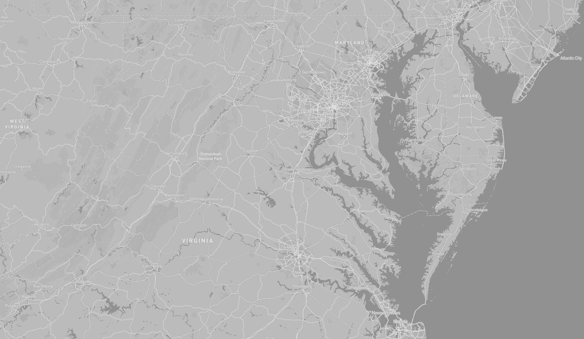
TOPOGRAPHY: Maryland has three distinctive regions defined by differing topography: the eastern part of the state with the Chesapeake Bay and the Atlantic Coast, the central section composed of the Piedmont and the western area containing numerous stretches of the Appalachian Mountains. Each of these areas has a unique look and feel ranging from sandy dunes dotted with seagrass in the east and low marshlands teeming with wildlife and large bald cypress near the Chesapeake Bay, to gently rolling hills of oak forests in the Piedmont Region, and pine groves in the Maryland mountains to the west.
The Chesapeake Bay nearly bisects the state, and the counties east of the bay are known collectively as the Eastern Shore. Most of the state’s waterways are part of the Chesapeake Bay watershed and the Chesapeake has historically played a central role in the state’s economic life.
Maryland has no natural lakes, mostly due to the lack of glacial history in the area. All lakes in the state today were constructed, mostly via dams.
The highest point in Maryland, with an elevation of 3,360 feet, is Hoye Crest on Backbone Mountain, near the border with West Virginia.
HISTORY: The Chesapeake Bay area was once inhabited by Paleoindians who hunted game and lived in small nomadic groups. According to archeologists, later Native American societies lived in villages of wooden longhouses close to water bodies where they fished and farmed the land. Agricultural products included beans, corn, tobacco, and squash. Villages often lasted between 10 and 20 years before being abandoned due to local resources such as firewood running out or soil depleting. As time went on, communities around Chesapeake Bay formed confederations such as the Powhatan, the Piscataway, and the Nanticoke. Each of these confederations consisted of a collections of smaller tribes falling under the leadership of a central chief. At the time of European contact the Native Americans in the area were mostly Algonquian peoples and, to a lesser degree, Iroquoian and Siouan.
Maryland’s early colonial settlements clustered around rivers and other waterways that empty into the Chesapeake Bay. Its economy was heavily plantation-based and centered mostly on the cultivation of tobacco. Demand for cheap labor from Maryland colonists led to the importation of numerous indentured servants and enslaved Africans. By the time of the Civil War, Maryland was moving away from plantation-style agriculture and beginning to industrialize. The state’s economy soared during the Industrial Revolution, driven by its seaports, railroad networks, and mass immigration from Europe.
Most of the historical Native American population in Maryland was composed of Algonquian and Iroquoian peoples, with a smaller Siouan-speaking population emigrating to the area in the mid-18th century. Many of the historical Native American peoples in Maryland assimilated into mainstream society and others were pushed into the Great Lakes region or Oklahoma as part of the “Indian removal efforts” in the 19th century. Today Maryland has no federally recognized tribes, but the state recognizes three tribes: the Piscataway-Conoy Tribe of Maryland, the Piscataway Indian Nation and Tayac Territory, and the Accohannock Indian Tribe.
The “Eastern Shore” refers to the part of Maryland that lies mostly on the east side of the Chesapeake Bay. Developed in the colonial for agriculture, this part of the state has remained a relatively rural region. It’s economy is dominated by three industry sectors: fishing along the coasts, especially for shellfish such as the blue crab; farming, especially large-scale chicken farms; and tourism, especially centered on the Atlantic coast and beach resort of Ocean City.
The region is connected to the rest of Maryland by the Chesapeake Bay Bridge, and the main “north-south” route is US Route 13 which connects to both Delaware and Virginia.
Because of its coastal and low-lying geography, the region is vulnerable to extreme weather events, including hurricanes and larger environmental issues like climate change and rising sea levels.
The Atlantic coast is protected by a vast chain of barrier islands extending from Maine to Texas. Barrier islands form when offshore sand deposits accumulate sufficiently to break the water surface or when sea level rise causes inland dunes to become separated from the mainland. These islands are highly dynamic constantly reshaped by storms and currents that transport sand south along the coast throughout the year. On a seasonal basis, harsh winter weather pulls sand from dunes and upper beaches, depositing it into offshore sand bars and reducing beach width. This process is reversed during milder summer weather, as gentler wave action acts to restore the shoreline.
HIGHLIGHTS: Sandy beaches,
Forested wetlands, Wildlife
observation, Wild ponies,
OSV driving, hiking,
interpretive information,
camping
HIGHLIGHTS: Camping,
Hiking, Cypress swamp
trail

HIGHLIGHTS: Dirt roads,
Hiking, Historic sites
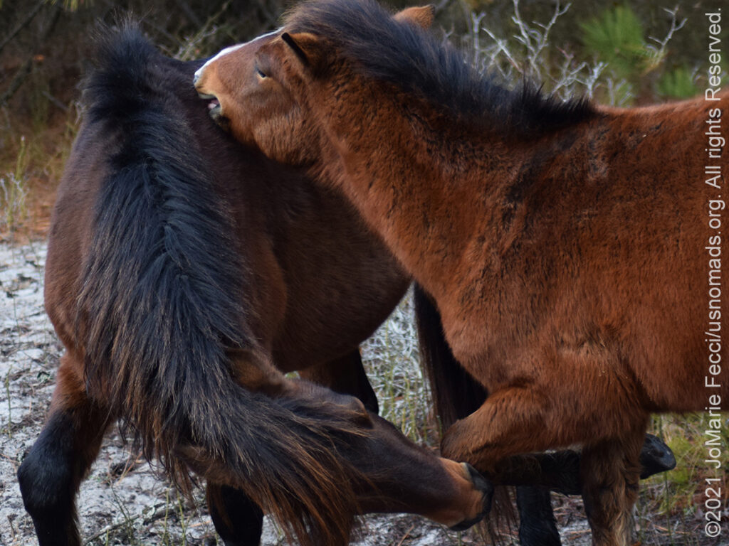
The Assateague Island National Seashore, managed by the National Park Service, stretches for 37-miles along a barrier island located off the eastern coast of the Delmarva Peninsula facing the Atlantic Ocean. The northern two-thirds of the island is in Maryland while the southern third is in Virginia. The Maryland section contains the majority of Assateague Island National Seashore and Assateague State Park. It is best known for its herds of feral horses, pristine beaches and the Assateague Lighthouse. The island also contains numerous marshes, bays, and coves.
Bridge access for cars is possible from both Maryland and Virginia, though no road runs the full north/south length of the island.
Like all barrier islands, Assateague has changed in form over the years. At one time, the island was connected to the lowest point of Fenwick Island. However, the 1933 Chesapeake–Potomac hurricane created an inlet south of Ocean City, Maryland. This inlet separated the two landforms. Normally, it would have silted back due to the littoral drift that ran from north to south. However, after the storm, between 1933 and 1935 a permanent system of artificial jetties was built to preserve the inlet as a navigation channel. As a result, the island has drifted considerably westward, and the two landmasses are now over 0.62 miles apart.
Between 1933 and the early 1960s, federal interest in creating a national seashore on the island alternated with periodic pushes for development. In 1950, a 15-mile section of the Maryland side of Assateague was plotted for development, and a paved road, Baltimore Boulevard, was constructed to traverse the new development. The Ash Wednesday Storm of 1962 destroyed or covered most of Baltimore Boulevard, and many of the structures on the island were destroyed. Although some private landowners on the island supported re-development, by this time the state of Maryland generally supported a national seashore and legislation was introduced in the United States Congress. After Congressional efforts did not produce final legislation in 1964, new legislation in 1965 was successful and Assateague Island National Seashore was formed.
Assateague’s terrain includes sandy beaches, salt marshes, maritime forests and coastal bays connected via a series of small bridges and causeways. Assateague is most famous for its resident Wild Ponies.
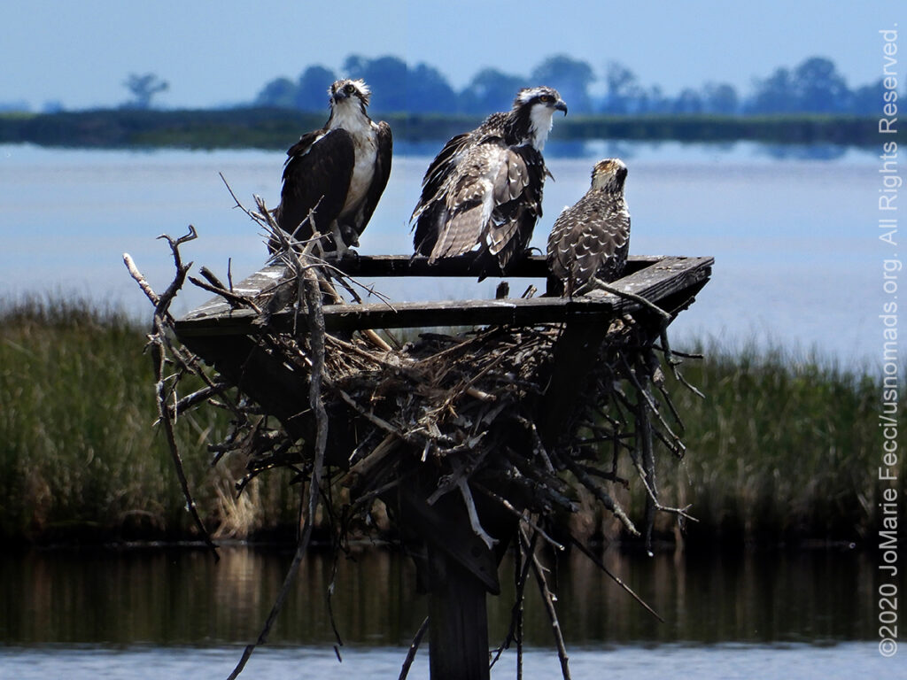
Assateague’s wild ponies are actually feral animals, meaning that they are descendants of domestic animals that have reverted to a wild state. Horses tough enough to survive the scorching heat, abundant mosquitoes, stormy weather and poor quality food found on this remote, windswept barrier island have formed a unique wild horse society. Local folklore describes the Assateague horses as survivors of a shipwreck off the Virginia coast. While this dramatic tale of struggle and survival is popular, there are no records yet that confirm it. The most plausible explanation is that they are the descendants of horses that were brought to barrier islands like Assateague in the late 17th century by mainland owners to avoid fencing laws and taxation of livestock. The horses are split into two main herds, one on the Virginia side and one on the Maryland side of Assateague. They are separated by a fence at the Virginia/Maryland State line. These herds have divided themselves into bands of two to twelve animals and each band occupies a home range. The National Park Service manages the Maryland herd. The Chincoteague Volunteer Fire Company owns and manages the Virginia herd, which is allowed to graze on Chincoteague National Wildlife Refuge, through a special use permit issued by the U.S. Fish and Wildlife Service. The permit restricts the size of the herd to approximately 150 adult animals in order to protect the other natural resources of the wildlife refuge. It is the Virginia herd which is often referred to as the “Chincoteague” ponies.
The Over-Sand Vehicle (OSV) zone at Assateague Island National Seashore contains miles of unspoiled beaches managed by the National Park Service to accommodate off-road enthusiasts and other beach goers. All vehicles using the OSV zone must display a valid OSV Permit.
Camping at Assateague can be an amazing experience. The Maryland side of the National Seashore has two main developed campgrounds and there are also two oceanside and four bayside backcountry camping areas for visitors who wish to backpack or paddle the island (no vehicle based back country camping is permitted). If there are no sites available at the National Seashore campgrounds, the Assateague State Park also has campgrounds.
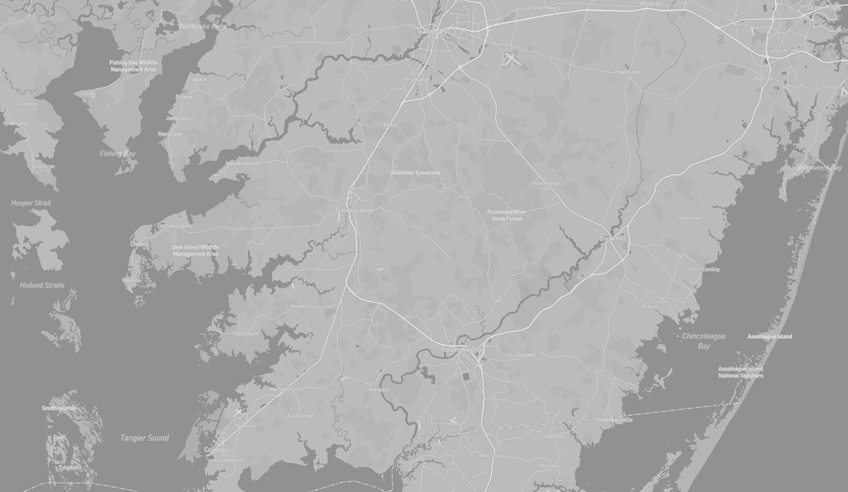
The Pocomoke River State Park in Worcester County, Maryland, comprises two areas within the larger Pocomoke State Forest–Shad Landing on the south bank of the river and Milburn Landing on the north bank.
The park’s combination of freshwater swamp and upland, as well as its location between northern and southern physiographic regions, allows for a great diversity of plant and animal life. Cypress swamps border the Pocomoke River which itself originates in the Great Cypress Swamp and flows southwesterly 45 miles to the Chesapeake Bay.
The park provides a base for a vast array of outdoor and tourist activities including fishing, biking, birding, boating, hiking and more.
POCOMOKE STATE PARK HIGHLIGHTS FROM OUR ROADBOOK: WAYPOINT–In Search of the Great Cypress Swamp | FIELD NOTES–Delaware to Maryland | FIELD NOTES—Maryland Waypoint Pocomoke River
The Pocomoke State Forest includes 17,676 acres of woodlands and is famous for its stands of loblolly pine and cypress swamps. Five areas in the forest, including the swamp, are designated wildlands areas. The forest’s combination of swamp and upland offers a great variety of plant and animal life, including white dogwood and pink laurel in the spring, bald cypress, river otters, and bald eagles.
Before the establishment of the State Forest much of the land had been cleared for farming or used as farm woodlots. When the depression era hit many of the farmers fell on hard times, resulting in the acquisition of large amounts of land by the Federal Government. In the mid to late 1930s, two Civilian Conservation Camps were located on the Forest. The camp workers did considerable road and trail work, established boundary lines, provided for fire protection and suppression, planted trees and performed recreation improvements.
The Pocomoke State Forest is considered “the Most Haunted Forest in Maryland” with tales that include severed heads, hitchhikers and ladies in white.
Over Sand Vehicle permits required for beach driving. Forest dirt roads open to street legal vehicles only.
Camping at campgrounds only (no dispersed camping). Camping available in the State Park and State Forest and at the National Seashore.
Gas, food and water are all easily accessible.
Sixteen of Maryland’s twenty-three counties, as well as the city of Baltimore, border the tidal waters of the Chesapeake Bay estuary and its many tributaries, which combined total more than 4,000 miles of shoreline.
The Chesapeake watershed is a world-class ecological treasure that is home to several thousand species of plants and animals, from blue crab to bald eagle. The region is steeped in history, including the culture and stories of American Indians, arrival of European colonizers, inspiration of the American Revolution, and impact of the Civil War. Across the watershed are diverse landscapes, from the Shenandoah Mountains to Smith and Tangier islands. The Bay’s waters represent a rich cultural heritage that includes world-renowned waterfowl hunting, trophy sport fishing, and the tradition of watermen who harvest fish, crabs, and oysters. Seafood, tourism, and marine transportation helped make the Chesapeake Bay a multi-billion-dollar economic driver for the mid-Atlantic region.
The Chesapeake is the largest estuary in the United States. The Bay is separated from the Atlantic Ocean by the Delmarva Peninsula and is approximately 200 miles long from its northern headwaters in the Susquehanna River to its outlet in the Atlantic. More than 150 major rivers and streams flow into the Bay’s 64,299-square-mile drainage basin, which covers parts of six states.
The Bay is the “ria,” or drowned valley, of the Susquehanna River, meaning that it was the alluvial plain where the river flowed when the sea level was lower. Much of the Bay is shallow. At the point where the Susquehanna River flows into the Bay, the average depth is 30 feet.

HIGHLIGHTS: Wildlife
observation, Wildlife drive
trail, hiking

HIGHLIGHTS: Historic
sites, Interpretive info
The Blackwater National Wildlife Refuge was established in 1933 as a waterfowl sanctuary for birds migrating along the critical migration highway called the Atlantic Flyway. The refuge is located on Maryland’s Eastern Shore and consists of over 28,000 acres of freshwater impoundments, brackish tidal wetlands, open fields, and mixed evergreen and deciduous forests. The name “blackwater” comes from the tea-colored waters of the local rivers, which are darkened by the tannin that is picked up as the water drains through peat soil in the marshes. The heart of Blackwater Refuge can be accessed via the Wildlife Drive, which is a paved road, approximately 3 1/2 miles in length, that takes visitors along the Blackwater River and offers excellent views of the local wildlife. Visitors can drive, bike, or walk the length of the Drive. Blackwater Refuge also offers three paddling trails, four hiking trails, and hunting, fishing, and crabbing opportunities. About half of the refuge is designated the Harriet Tubman Underground Railroad National Monument. Harriet Tubman was raised on the land that now makes up the refuge. Born in 1822, Tubman spent her childhood as a slave working on farms that abut or are included within the boundary of the refuge. As a young adult she worked as a timber laborer on the north side of the Blackwater River. Tubman’s early experiences here gave her a familiarity and understanding of the natural landscape that she was able to draw on as she guided escaping slaves along the Underground Railroad routes.
The Harriet Tubman Underground Railroad National Historical Park is centered around the larger Harriet Tubman Underground Railroad Scenic Byway. The park’s Visitor Center serves as an orientation center and gateway to the byway, with exhibits, a film, restrooms, picnic facilities, and staff to offer further information and guidance to visit other sites along the itinerary.
This self-guided, scenic driving tour includes more than 30 sites, many of them with outdoor markers or interpretive signs that share the story of that place, and winds for 125 miles through Dorchester and Caroline Counties on Maryland’s Eastern Shore before continuing another 98 miles into Delaware and ending in Philadelphia, where Tubman first found freedom.
The Visitor Center serves as the park’s primary visitor destination. Its design concept, “The View North,” symbolizes the importance of moving northward, away from slavery and into the possibilities of freedom; a quiet, open legacy garden offers walking paths for meditation and reflection.
A partnership between the Maryland Department of Natural Resources, the National Park Service, and Harriet Tubman Underground Railroad State Park operates the 16,000-square foot, LEED Silver certified visitor center and administration building, along with a 2,700-square foot open air pavilion with a fireplace and picnic tables. The state park is a 17-acre site adjacent to the Blackwater National Wildlife Refuge. The site is also home to the National Underground Railroad Network to Freedom program, which partners with local, state, and federal entities to commemorate events, preserve sites and resources, and educate the public about the national significance of the Underground Railroad.
Dirt roads around the Blackwater NWR are open to street legal vehicles only.
Camping at campgrounds only (no dispersed camping)
Gas, food and water are all easily accessible.