Delaware is often part of our favorite north-south coastal route that explores the barrier islands of the Atlantic coast. While it is the second smallest state in the US, it has some interesting spots for enjoying the outdoors beyond just “the beach.”
Overview: Delaware “tourism” is primarily focused on summer beach destinations along the Atlantic coast and the resort towns of Rehoboth Beach, Lewes, Dewey Beach, Bethany Beach, South Bethany, and Fenwick Island. And while the state does not really have any “off road” destinations or even simple dirt roads, it does have some interesting paved routes to explore different regions. You can check out the various “Scenic Byways” on this official site. Beyond these “byways” there are also some really great places to go exploring on public lands, particularly along the Atlantic coast and in the more rural southern part of the state.
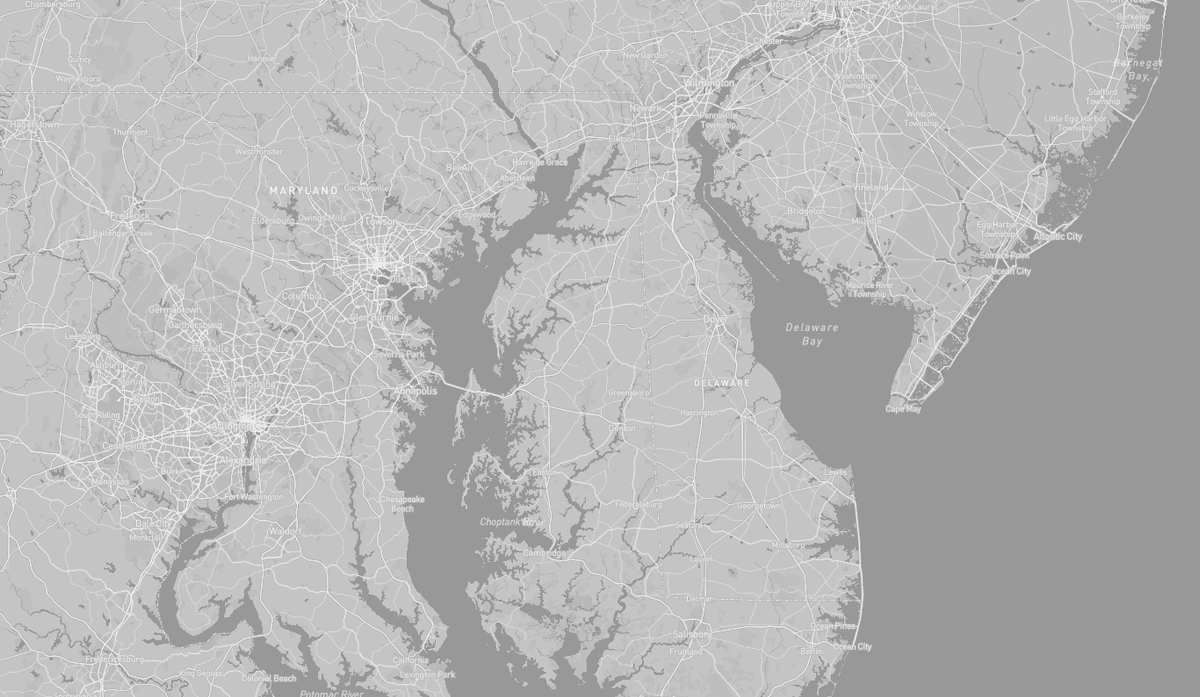
TOPOGRAPHY: Delaware is 96 miles long and ranges from 9 miles to 35 miles across, with a land area of just 1,982 square miles. Delaware, together with the Eastern Shore counties of Maryland and two counties of Virginia, form the Delmarva Peninsula, which stretches down the Mid-Atlantic Coast. Delaware is on a level plain, with the lowest mean elevation of any state in the nation. Its highest elevation, located at Ebright Azimuth, is less than 450 feet above sea level. The northernmost part of the state is part of the Piedmont Plateau with hills and rolling surfaces. The Atlantic Seaboard fall line approximately follows the Robert Kirkwood Highway between Newark and Wilmington; south of this road is the Atlantic Coastal Plain with flat, sandy, and, in some parts, swampy ground. A ridge about 75 to 80 feet high extends along the western boundary of the state and separates the watersheds that feed Delaware River and Bay to the east and the Chesapeake Bay to the west.
HISTORY: Before Delaware was settled by European colonists, this land was home to the Eastern Algonquian tribes known as the Unami Lenape, or Delaware, who lived mostly along the coast, and the Nanticoke who occupied much of the southern Delmarva Peninsula. These indigenous peoples had a settled hunting and agricultural society. In 1631 Dutch traders established the first colonial presence at at Zwaanendael, near present-day Lewes. The Lenape soon became middlemen in an increasingly frantic fur trade before being pushed off their lands on the Delaware River by the mid-18th century. Colonial Delaware was a largely agricultural region, producing tobacco with plantation-style cultivation based on slave labor, similar to the system in southern states. By the early 1800’s industrialization began to transform parts of the states into a manufacturing center, and by 1810 two-thirds of Delaware’s slaves had been freed. Delaware’s history as a “border” state between north and south, has led it to exhibit characteristics of both regions. Generally, the rural Southern regions of Delaware below the Chesapeake and Delaware Canal embody a Southern culture, while densely-populated Northern Delaware above the canal is more urban and has more in common with the Northeast. Native American communities that maintain a strong presence in Delaware are the Lenape, which is today headquartered in Cheswold, and a band of the Nanticoke tribe that resides in Sussex County.
The Delaware Bay area we are most interested in is the lower section which features a wilder, less developed landscape defined by wetlands and a few small towns. Lewes, one of the first towns to be established in the state, has a quaint historic district and is the Delaware terminal for the Cape May-Lewes Ferry that links it to New Jersey and one of our favorite coastal north-south routes. The maritime heritage of Lewes gives it a unique character, with a blend of architectural styles that spans almost four centuries.
From Lewes we have two different “slow road” options to explore further south. One will follow the Atlantic Coast along the sandy beaches of a series of barrier islands, the other goes into the interior where the remains of the Great Cypress Swamp beckon.
But right along the Bay near Lewes there are a few great locations to discover and experience both the wetlands marshes of the bay and the sandy beaches of the Atlantic coast. And there’s some interesting military history, too.
The short, 12.5 mile “Historic Lewes Byway,” links these locations and captures the 378-year history of the “First Town in the First State of the United States of America”. Located at the mouth of the Delaware Bay, with a good harbor and lighthouses, Lewes was the perfect spot for a major shipping channel, for rescuing passengers and crews of foundering ships, and for defending the Delaware Bay and adjacent communities.
Delaware Bay, between the states of Delaware and New Jersey, is the estuary outlet of the Delaware River. The bay’s freshwater mixes with the saltwater of the Atlantic Ocean over an area of approximately 782 square miles. It’s shores are largely composed of salt marshes and mudflats, with only small communities inhabiting the lower bay.
The bay is one of the most important navigational channels in the United States; it is the second busiest waterway after the Mississippi River. Its lower course forms part of the Intracoastal Waterway. The need for direct navigation around the two capes into the ocean is circumvented by the Cape May Canal and the Lewes and Rehoboth Canal at the north and south capes respectively. The upper bay is connected directly to the north end of Chesapeake Bay by the Chesapeake and Delaware Canal.
The protected salt marsh wetlands bordering the bay, serve as a breeding ground for many aquatic species, including oysters and horseshoe crabs (Delaware Bay hosts the largest population of horseshoe crabs in the world).
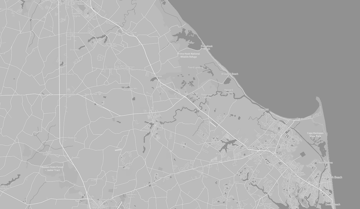
The landscapes of the Delaware Bay area are in a constant state of transition due to rising sea levels. Over the past 100 years the sea level has risen 13 inches. The protected habitats of the Prime Hook National Wildlife Refuge are increasingly threatened.
Over the past 85 years, about
500 feet of beach front at Prime Hook have been lost. Experts predict global sea levels will continue to rise anywhere from one to three meters over the next century. Moreover, increasing frequency and intensity of storm events is causing additional flooding and erosion.
The Refuge has worked with researchers to determine the best course of action to protect the wildlife habitats at Prime Hook. Rebuilding the dune line, while critically important, is not enough. Rather, a careful and detailed marsh restoration
plan, which rebuilds a resilient mix of salt, brackish, and some freshwater marsh, is a sustainable option to help Prime Hook adapt to the realities of sea-level rise and climate change.
HIGHLIGHTS: Vehicle
Ferry to Cape May NJ,
scenic views
HIGHLIGHTS: Wildlife
viewing, Hiking, Paddling
HIGHLIGHTS: Beaches,
Dunes, Historic
lighthouse, Hiking
HIGHLIGHTS: Historic
structures, Military
history
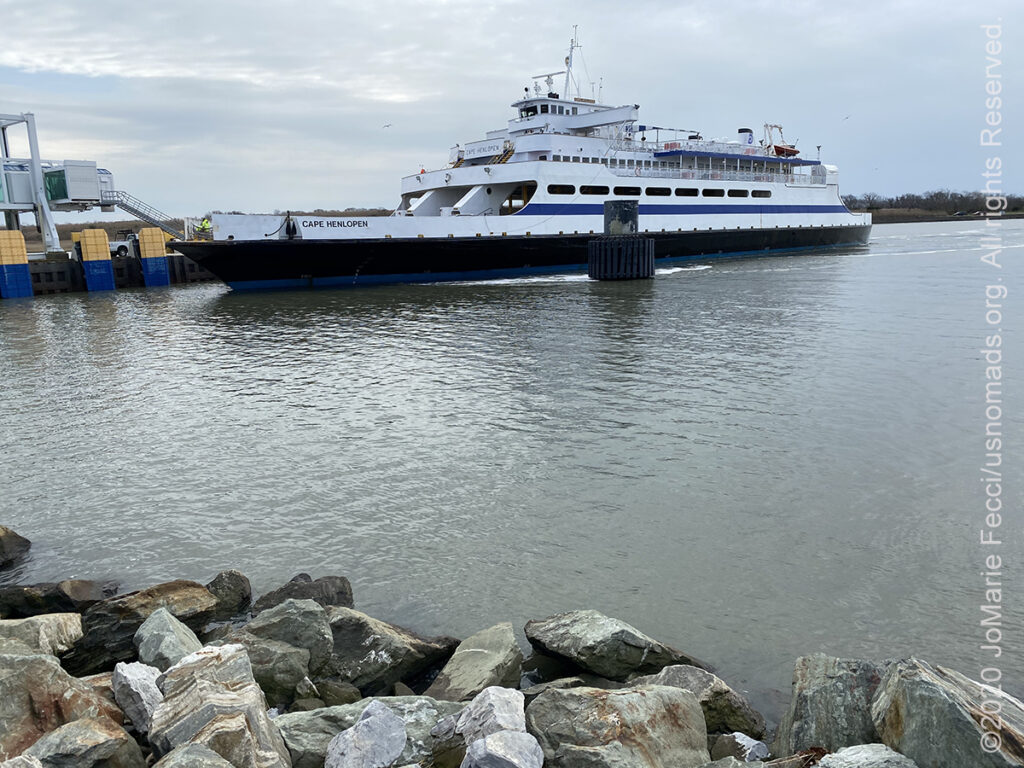
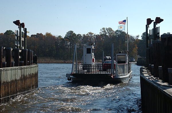
The Cape May–Lewes Ferry is a ferry system in the United States that traverses a 17-mile crossing of the Delaware Bay connecting North Cape May, New Jersey with Lewes, Delaware. The ferry constitutes a portion of U.S. Route 9 and is the final crossing of the Delaware River-Delaware Bay waterway before it meets the Atlantic Ocean. As the ferry is a part of US 9, it is included as part of the U.S. Highway System. The only other U.S. Route to use a ferry is U.S. Route 10, which uses the SS Badger across Lake Michigan. Routewise, taking the ferry avoids going around the Delaware Bay and avoids highways and bridges such as the New Jersey Turnpike, Delaware Memorial Bridge, US 13, and DE 1.
The ferry carries vehicles and foot passengers, and the one-way journey takes approximately 85 minutes. Along the way there are views of three lighthouses: the Cape May Light in New Jersey, and the Harbor of Refuge Light and Delaware Breakwater East End Light near Lewes.
The ferry crossing dates back to the 1920, when the idea was to use a World War I military ship to transport passengers and cars across the Delaware Bay, but the project was abandoned after a few months. It wasn’t until almost 50 years later that ferry service actually began on July 1, 1964. The ferry utilized a fleet of five steamers purchased from Virginia, before replacing them with more modern ships in the 1970s.
The ferry was conceived with transportation as its primary use, providing a connection between the south Jersey Shore towns and the Delaware Beaches and Ocean City, Maryland, on the Delmarva Peninsula. It was only later on that the he Delaware River and Bay Authority (DRBA) recognized the ferry’s potential as a tourist attraction. And while it continues to provide transportation between Delaware and New Jersey, the experience has also been optimized to draw in tourists.
Prime Hook National Wildlife Refuge, established in 1963, is comprised of over 10,000 acres of forest, coastal marsh, tidal stream and freshwater creek habitats flowing to the Delaware Bay. Situated along the southwestern shore of the Bay, the refuge is at the heart of key staging areas for migrating, breeding, and wintering habitats for waterfowl, shorebirds, waterbirds, and land birds along the Atlantic Flyway and Western Hemisphere. The refuge also provides habitat for other species like the bald eagle and the endangered Delmarva fox squirrel.
Prime Hook got it’s name from Dutch settlers who discovered an abundance of purple beach plums — they called the area “Priume Hoek” meaning “Plum Point.”
Roughly 80 percent of the refuge is a mix of fresh and saltwater wetlands stretching from Slaughter Beach in the north to the Broadkill River in the south. Tidal salt marshes are highly productive habitats and support a rich diversity of fish and wildlife. They are also one of the most vulnerable habitats in the world. The refuge has almost 2,300 acres of tidal salt marsh, but they are a rapidly diminishing habitat type along the East Coast. Tidal salt marsh communities are particularly important nursing grounds for fish and shellfish.
The refuge offers different kinds of opportunities to appreciate the wildlife and coastal landscapes. Visitors can connect with nature by strolling down six miles of walking trails or from their vehicles along the four State roads crossing through the refuge. There is a photography blind and an observation platform. There is also a self-guided paddling trail along a seven-mile stretch of Prime Hook Creek.
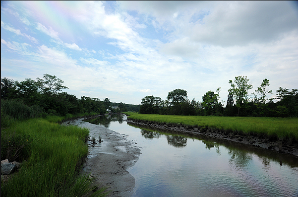
Scenic views of Canary Creek can be found on New Road — and near the bridge on New Road is a locally famous crabbing spot. Canary Creek and the Great Marsh account for over 2,000 acres of preserved salt marshes and a gateway to the nationally recognized Prime Hook Wildlife Refuge.
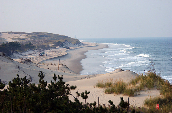
The 7,000-acre Cape Henlopen State Park where the “Great Dune” rises 80 feet above sea level is famous for its “walking dunes” that slowly move across the pine forests. The park features pristine beaches, wild seaside forests, and flowing dune landscapes. Off the coast on the bay side are two lighthouses: the Harbor of Refuge Light and the Delaware Breakwater East End Light. Visitors can see where the Delaware Bay meets the Atlantic Ocean, and experience “the Point”, a great place for viewing birds, dolphins, seals, and more.
“The Point” shaped the history of this landscape. For millenia, native people lived off the land’s abundant and rich resources and in the late 1682, William Penn granted the land and allowed citizens to harvest many of the same resources, establishing one of the first public lands in what would become the United States.
A diverse collection of habitats makes up the coastal ecosystem of Cape Henlopen State Park. Barrier dune, coastal beaches, and maritime forest are home to many species of plants and animals. Visitors can visit the Seaside Nature Center to participate in an interpretive program or learn about the park’s native plants and animals.
The pine covered dunes of Cape Henlopen State Park are open to camping in some areas with over 150 campsite available. And there are a variety of marked nature and hiking trails at the park, ranging from a beach to pine forests. One of the most spectacular hikes is the Walking Dunes Trail, a 2.6-mile loop trail (suitable for all skill levels) that goes through impressive sand dunes that offer one-of-a-kind views. The trail has a firm crushed gravel surface with gentle grades for most of the way. While the highlight may be the Great Dune, which towers 80 feet above sea level at the trail’s northwestern edge, sand isn’t the only scenery along the Walking Dunes Trail — much of the route passes through woodlands and tidal marsh.
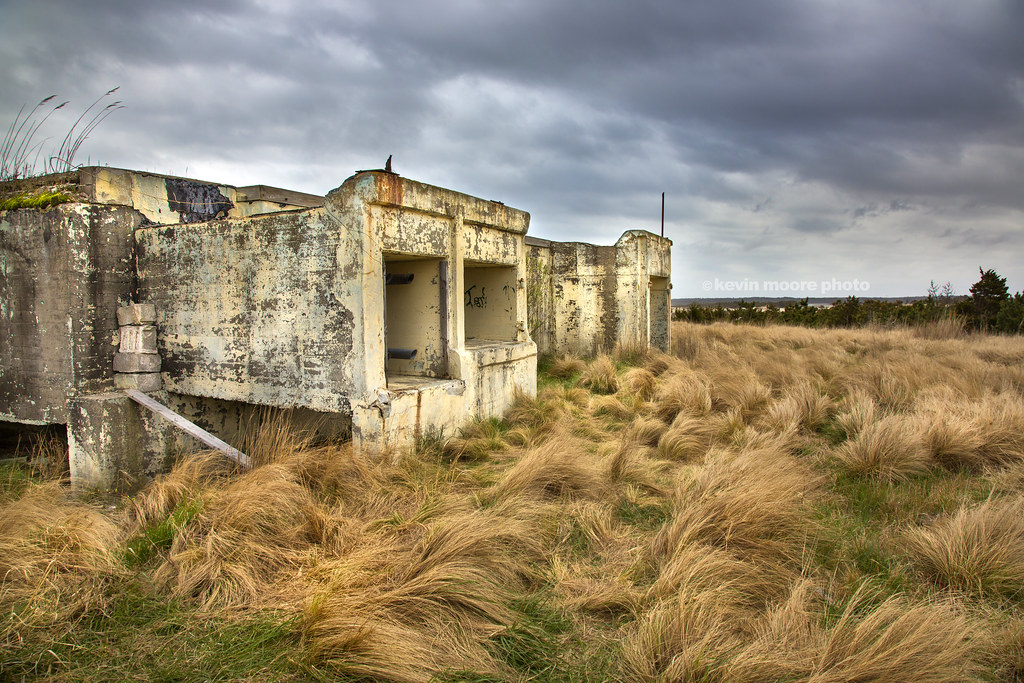
Few people realize that buried beneath the picturesque terrain at Cape Henlopen State Park are a series of underground bunkers built to protect the U.S. from German invasions during World War II. The cape has been an important strategic location for the U.S. Navy and Army throughout history from the time of the American Revolution right up through World War II.
The area’s strategic position led to the construction of Fort Miles with its iconic fire control towers along the Atlantic coast. The coastal defenses date to 1941, when the fear of German U-boats invading Philadelphia via the Delaware River led to the construction of secret, state-of-the-art installations built within the massive natural sand dunes that provided the perfect cover for an array of heavy guns. The big guns were capable of firing artillery rounds up to 10 miles. A series of tunnels reportedly connects the bunkers, allowing the 2,500 soldiers that were stationed at Fort Miles to move undetected.
Numerous bunkers, concrete observation towers and the pier built to accommodate the laying of mines on the harbor floor remain today. The site was officially decommissioned and transferred to the Delaware State Park system in 1964. Access to the abandoned bunkers and tunnels is limited to park officials, but the above ground structures are visible to visitors and it is possible to tour Battery 519 and climb to the top of the Observation Tower. The bunkers and towers are accessible from the north entrance to Cape Henlopen State Park, just off Route 9 in Lewes.
The Fort Miles Historical Area includes Battery 519, six barracks buildings, a fire control tower, an orientation building, and the Fort Miles Artillery Park. The museum tells the story of Fort Miles, a key piece of our nation’s coastal defense, from World War II through the early 1970’s. Museum exhibits and artifacts within Battery 519, a 15,000-square-foot fortified underground chamber, bring to life Delaware’s wartime stories of submarine encounters and surrender, daring actions of civilian pilots, and hometown heroes who sacrificed for our freedom. The Museum’s collection of armaments provides visitors a unique opportunity to experience first-hand how state-of-the-art technology from an earlier day was used to defend the homeland.
Paved roads only.
Camping at campgrounds only (no dispersed camping). Good camping opportunities at Cape Henlopen.
Gas, food and water are all easily accessible.
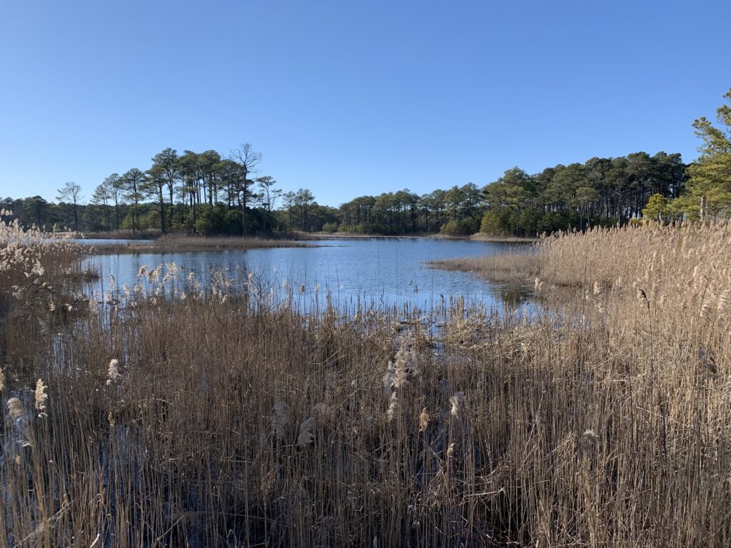
The inland portion of southern Delaware is a mosaic of cultivated farmland and forested wetlands. Much of this area was once covered by the Great Cypress Swamp which stretched over 50,000-plus acres. Historically swamps were considered wastelands whose best use could only be attained through “reclamation projects” and many interior wetlands like the Great Cypress Swamp were destroyed through actions such as drainage for agriculture and filling in for industrial or residential development. Today there are only a few places left here where it’s possible to get a sense of what that primal swamp environment was like.
Heading inland from the coast our first stop includes a search for the “remains” of the Great Cypress Swamp before heading to Trap Pond State Park where the solitude and natural beauty of the ethereal swamp experience has been preserved. Continuing west towards Maryland, its fun to take a historic ferry across the Nanticoke River.
The Delaware swamplands have an interesting history. Over centuries as groundwater flowed through the swamps and streams, plants and bacteria oxidized soluble iron compounds in the water solid mineral deposits, high in iron, were left behind. These accumulated layers of “bog iron” were discovered as European settlers moved into this area in the mid-1700s. The settlers began to “mine” and process the iron deposits, using the power of flowing streams for bellows, and the vast stands of timber for charcoal to fuel furnaces and forges. The iron industry continued until the time of the American Revolution when British blockades of the Chesapeake Bay effectively shut down it down. However, the lumbering continued as settlement increased. Soon small streams were dammed, both for powering sawmills and as transportation ponds for floating logs out of the swamps. The Baldcypress swamps and stands of Atlantic White Cedar were sought-after because both trees provided lumber that was insect and rot-resistant.
As the forests were cut down, agriculture slowly took over as the main economic activity in the region.
Swamps are non-tidal wetlands that are dominated by woody shrubs or trees. They have saturated soils or standing water during certain times of year, which creates a unique environment that only particular plants can survive. Swamps serve vital roles in flood protection and help to clean our waters. There are many different types of swamps. In Delaware, two examples are Atlantic white cedar and bald cypress swamps.
Atlantic white cedar swamps occur in poorly-drained, acidic, highly-organic soils, either along river floodplains, or in the headwaters of mill ponds. They feature a white cedar tree canopy with deciduous (typically maple/gum) trees mixed in. A unique community of sphagnum moss and carnivorous plants occupy the forest floor.
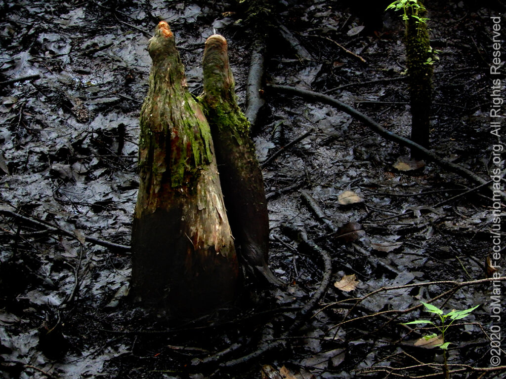
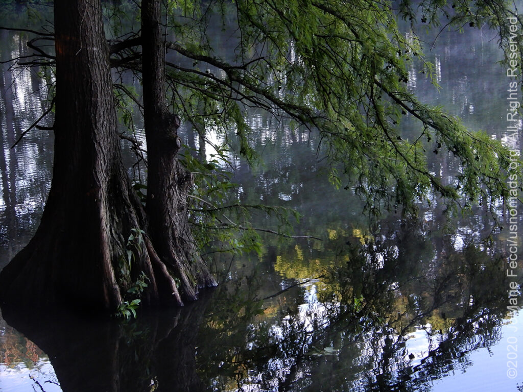
Bald cypress swamps in Delaware are the northernmost natural examples of these areas in the United States, and thus comprise a unique ecosystem to this region. Easily distinguished by the presence of the deciduous, knobby-kneed cypress trees, these swamps can be found within forested floodplains of some southern Delaware rivers and creeks.
Prior to extensive timbering and drainage during the 1800s and 1900s, white cedar swamps were abundant in Delaware, including hundreds of acres within the Great Cypress Swamp. Though now scarce in Delaware, cedar swamps provide important habitat for certain species such as sundews, pitcher plants, dragonflies, and salamanders, which can be found in few other places throughout the state.
Bald cypress trees were also heavily timbered during the 1700s and 1800s for their rot-resistant wood, which was used for building things like ships and roof shingles. Additionally, removing these trees gave access to the nutrient-rich soils in which they grow that were sought after for agriculture. Today, many of these swamps are on state- or non-profit-owned property and are being maintained or restored. However, these wetlands are sensitive and easily disturbed by adjacent land use activities.
HIGHLIGHTS: Historic
swampland, Conservation/
Restoration site
HIGHLIGHTS: Hiking,
Camping, Paddling,
Swamp education center
HIGHLIGHTS: Historic
cable ferry
Trap Pond State Park is a 3,653 acre state park located near Laurel, Delaware. It is one of the largest surviving fragments of what was once an extensive wetland. The state park features an extensive patch of bald cypress trees. Many birds flock to stands of bald cypress, including great blue herons, owls, warblers, and pileated woodpeckers. The rot-resistant wood of Trap Pond’s bald cypress trees was extensively harvested starting in the 18th century. The lumbermen extensively altered the morphology of the wetland, damming its outflow to create power for a small sawmill to cut the timbers. This dam helped to create what is now Trap Pond, named after the Trap Mills, which were known by that name as early as the 1860s. The pond was enlarged in later years as nearby farmers laid down drainage tiles to de-water their wetlands for agriculture. After the old-growth cypress timber had been harvested, the pond and adjacent surviving wetlands were re-used as the drainage sump for the surrounding farmers of Sussex County. In the 1930s, the federal Civilian Conservation Corps listed the pond as a place of recreation development. The Delaware legislature took over the land and named it as a state park on June 22, 1951, becoming the first state park in Delaware.
TRAP POND HIGHLIGHTS FROM OUR ROADBOOK: WAYPOINT–In Search of the Great Cypress Swamp | FIELD NOTES–New York to Delaware | FIELD NOTES–Delaware to Maryland
The Great Cypress Swamp is a forested freshwater swamp located on the Delmarva Peninsula in south Delaware and southeastern Maryland. As of 2000, it was the largest contiguous forest on the Delmarva Peninsula. The northern most bald cypress swamp in the USA, it once stretched across some 50,000-plus acres but hundreds of years of ditching and draining for agriculture threatened to obliterate it until the Delaware Wild Lands organization consolidated 10,000 acres protecting what remains of this once vast swamp. Remnants of the swamp can also be seen at Trap Pond State Park in Delaware and Pocomoke River State Park in Maryland. The swamp’s geology of sandy ridges and shallow depressions reflects its ice-age origins when the Delmarva Peninsula was a desert of windswept sand dunes. The surviving swaths of the old Cypress Swamp haven’t changed very much over the centuries. They can be quite spooky as true cypress swamps never really see the full light of day—it’s always somewhere between dark and semi-dark. The bald cypress looks like a pine tree, but it thrives in flood-prone places where most other trees would drown and die. The main trunk is often surrounded by cypress knees, a distinctive structure forming above the roots of the tree. Knees are woody projections sent above the normal water level, roughly vertically from the roots, with a near-right-angle bend taking them vertically upward through water. Their function is unknown, but some hypotheses state that they might help to aerate the tree’s roots, create a barrier to catch sediment and reduce erosion, assist in anchoring the tree in the soft and muddy soil, or any combination thereof. The Great Cypress Swamp once yielded much timber, but overharvesting and a disastrous peat fire in 1930, permanently destroyed much of its vegetation. One of the fires (supposedly started when a moonshiner’s still exploded) burned for eight months, leading it to be deemed the “Burnt Swamp” by local residents.
GREAT CYPRESS SWAMP HIGHLIGHTS FROM OUR ROADBOOK: WAYPOINT–In Search of the Great Cypress Swamp | FIELD NOTES–New York to Delaware | FIELD NOTES–Delaware to Maryland
The Woodland Ferry transports vehicle and foot passengers across the Nanticoke River between the towns of Seaford and Laurel. The ferry crossing is free. The boat can only accommodate six vehicles. Historically known as Cannon’s Ferry, it is one of the oldest, if not the oldest, ferries in continuous operation in the United States.
The cable ferry was established here in the 1740s by James Cannon, and the ferry was privately operated by the Cannon family until the mid-19th century, when the General Assembly authorized the county to operate a free ferry at the location of “Cannon’s Ferry”. In 1935, the Delaware Department of Transportation assumed responsibility for the operation of the ferry and has continued to operate it into the 21st century.
The ferry is of historical importance as one of the locations where slave runner Patty Cannon embarked with kidnapped refugee slaves and free blacks. She shipped them to Georgia where the free blacks were sold into slavery and refugee slaves returned to servitude.
A cable ferry is a ferry that is guided across a river or large body of water by cables connected to both shores. Early cable ferries often used either rope or steel chains, with the latter resulting in the alternative name of chain ferry. Both of these were largely replaced by wire cable by the late 19th century. Cable ferries have probably been used to cross rivers and similar bodies of water since before recorded history. Examples of ferry routes using this technology date back to the 13th century Hampton Ferry in England.
Paved roads only.
Camping in campgrounds only. (No dispersed camping). Good camping at Trap Pond.
Gas, food and water are all easily accessible.
Taking the coastal route south isn’t the best plan in summertime when the beaches are crowded and Delaware’s Route 1 is one long traffic jam, but in the off-season this is a great area for exploration of the barrier island landscapes.
Running for roughly 103 miles, Delaware Route 1 (DE 1) is the longest highway in the state, and it takes us through the chain of barrier islands that begin with Cape Henlopen near Lewes and continue south to Fenwick Island near the Maryland border and extending all the way down through Assateague Island to the mouth of Chesapeake Bay.
The coastal beach towns have different characters, with some like Bethany Beach and South Bethany more quiet while others like Dewey Beach and Rehoboth Beach are known for their cosmopolitan bustle. However, during the off-season, these differences matter less, and it’s easier to experience the wilderness areas and even enjoy some solitude along the Atlantic shores.
Wandering quiet beaches and maze-like back bay trails it is easy to imagine the time when this part of the Delaware coast provided a refuge for pirates. One local legend said pirates buried treasure on Cedar Island in Little Assawoman Bay. Too bad Cedar Island has almost washed under the bay (the same thing happened to Seal Island in 2010).
The Delmarva Peninsula includes the vast majority of the state of Delaware and parts of the Eastern Shore regions of Maryland and Virginia. The peninsula is 170 miles long. In width, it ranges from 70 miles near its center, to 12 miles at the isthmus on its northern edge. The entire Delmarva Peninsula falls within the Atlantic Coastal Plain, a flat and sandy area with very few or no hills; the highest point in the peninsula is only 102 ft above sea level.
Delmarva’s barrier island system begins in Delaware and researchers have noted that shorelines are retreating towards the mainland at an increasingly rapid rate. The islands are becoming smaller and thinner while the inlets and back-bay areas are becoming bigger. Rising sea levels contribute to this island shrinking, but storms are also a factor. Barrier islands are frequently exposed to hurricanes and tropical storms, when widespread washover can alter the shoreline position drastically.
Along much of the East Coast, long stretches of thin, sandy islands provide a buffer from surging waters during storms and help protect the mainland.
Barrier islands form when waves and wind push sand into mounds that gradually enlarge into dunes and then islands, with tides and currents bringing in water at certain spots to create inlets. Changes to any part of this delicately balanced system can re-form an island’s shape and location, as well as the surrounding bays and lagoons. In fact, East Coast barrier islands were once much farther out to sea near the edge of the continental shelf and have moved landward as water levels crept higher.
HIGHLIGHTS: Beaches,
Kayaking, Hiking
HIGHLIGHTS: Wildlife, Observation tower, Kayaking
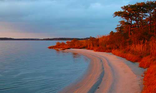
Delaware’s southernmost beach, Fenwick Island State Park offers three miles of ocean beaches along with access to the Little Assawoman Bay.
The park is located on Fenwick Island, a narrow strip of land between the Atlantic Ocean and Little Assawoman Bay. It is largely undeveloped in comparison to the beach communities that surround it. Fenwick Island was initially “protected” from development because it is a narrow peninsula that is just 3 miles wide with constantly shifting dunes. This allows visitors to experience two different coastlines on one patch of land.
Fenwick Island State Park is home to a World War II-era fire control tower that helped protect the coastline. Ghost crabs are a popular site along the water, and programs are offered to learn about these and other natural resources at the park.
Kayaking is a favorite pastime at this tranquil downstate park. Coastal Kayak rentals, right on the shores of the Little Assawoman Bay, is a must for visitors looking for an exciting paddling experience on the Inland Bays. This state park concession provides everything you need for a water adventure to suit your paddling needs. Sunsets on the Assawoman Bay are spectacular anytime of the year.
Fenwick Island is named for Thomas Fenwick a planter who migrated to the Thirteen Colonies from York, England. Some legends contend that Fenwick swam ashore at Fenwick Island after being thrown overboard by pirates. Most historians do not believe that this happened. It is, however, likely that Fenwick’s future son-in-law, William Fassett, did swim ashore after being cast off by a group of pirates. He would go on to marry Fenwick’s daughter, Mary and claim the land of Fenwick Island for himself.
For 100 years pirates raided the ships of local and passing sea captains, using the harbors of Little Assawoman Bay to the west of Fenwick Island State Park as a safe haven. Delaware was a gritty area rife with crime in that time period, especially near the beaches. Miles of desolate coastline separated tiny settlements, leaving pirates with plenty of places to hide and set up camp. With commerce thriving in Philadelphia many ships had to pass Delaware making piracy lucrative. Blackbeard and Capitan Kidd were both familiar figures in the area and you can learn more about the history of piracy in Delaware at DiscoverSea Shipwreck Museum in the town of Fenwick.
Assawoman Bay State Wildlife Area, just outside of Fenwick Island at 7604 Mulberry Landing Rd, Frankford, DE 19945, is one of the most serene places in Delaware. This wildlife refuge consists of nearly 3,000 acres that were once farmland, but have been reclaimed by nature. The Assawoman Bay itself separates Ocean City, Maryland from the Mainland, and can be accessed from Fenwick Island. The Wildlife Area is part of the Little Assawoman Bay, and it’s managed by the Delaware Department of Fish and Wildlife. It’s the perfect place to drop in a kayak and explore miles of waterway. It’s common to see bald eagles, giant woodpeckers, and even river otters in the water!
There is a 50-foot lookout tower at Assawoman Bay Lookout Point (N 38° 29.503 W 075° 04.783) that is a great place from which to spot the area wildlife.
Paved Roads only
Camping at campgrounds only (no dispersed camping)
Gas, food and water are all easily accessible.