
In preparation for a longer upcoming trans-Saharan journey we conducted a scouting trip in south-eastern Algeria during April 2017. We spent about two weeks traversing roughly 650 miles of desert, primarily off-road. Using the town of Djanet as a base point we looped southeast almost to the Libyan border, and then back north west to the Ihrir oasis. The journey was made in a locally-sourced Toyota Land Cruiser and focused on the UNESCO world heritage sites around Tassili N’ajjer. The primary goal of this mission was to assess terrain, security, driving conditions, logistical concerns and approximate timeframes for a future expedition.
< BACK: TO EL BERDJ | ALGERIA REPORT HOME | AHEAD: TO IN DJAREN >
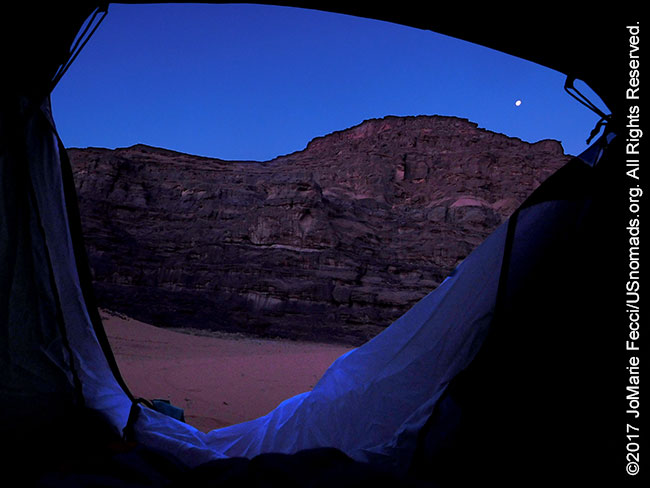
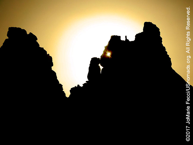
The morning sun was late to rise over the sheer-sided canyon walls of El Berdj. Our camp location in a narrow fold of rock proved to be ideal, providing shade in both morning and afternoon as well as protection from the wind. The desert had gotten quite cold overnight and I was glad I had brought my winter sleeping bag. This part of the Sahara typically sees a 25-35 degree temperature fluctuation between day and night. It was still chilly in the morning, but as soon as the direct sun hits the open desert the heat could get unbearable. The search for shade would become a strategic necessity in our routing and timetable, and I would be reminded more than once that the camel caravans of old moved mostly at night.
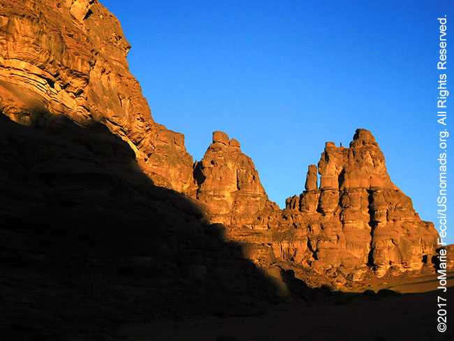
The eroded sandstone walls of El Berdj seemed to glow red as we set off to follow the line of the main canyon in a north-easterly direction. We were headed into an open-air treasure-trove of rock carvings and cave paintings. The Tassili n’Ajjer grouping of prehistoric cave art is considered one of the most important in the world. Over 15,000 drawings and engravings record the climatic changes, the animal migrations and the evolution of human life from 6000 BC to the first centuries of the present era. The artwork is “hidden in plain sight” spread out across the rock walls and geological formations in a surreal lunar landscape defined by rock and sand.
We stopped at the base of what looked like a sheer wall, then carefully found footing along the rockspill making our way up to a non-descript ledge shaded by a larger outcropping of rock. It took my eyes a few seconds to adjust to the darkness of the shadow, but then I saw the outlines etched deeply into the surface — overlapping cows, with expressively rendered faces and floppy ears. It seemed bizarre to see cows in such a barren desert. But one of the most interesting aspects of the Tassili art is the insight it offers into the desertification of the Sahara. This area was once lush and green. Water was plentiful enough for the people to herd cows here.

The Sahara wasn’t always a desert. Hundreds of millions of years ago, it was covered by expansive inland seas. Later, while Europe was still shivering under an Ice Age, the Sahara became temperate, with lakes and forests rich in wildlife. A comfortable Mediterranean climate prevailed and supported a population of hunters and herders. Though archaeological evidence suggests that human habitation in Algeria goes back as far as 200,000 BC, it was at this period between 15,000 and 10,000 BC that two distinct groups, referred to today as the “Oranian” and the “Capsian“, appear in North Africa. Their integration with indigenous peoples spread the Neolithic culture characterized by animal domestication and subsistence agriculture across the Sahara. They were the ancestors of the Berber tribes and the rock art of Tassili N’Ajjer is one of the greatest sources of knowledge about their history.
The Tassili art depicts vibrant and vivid scenes of everyday life during the Neolithic Subpluvial period (about 8000 to 4000 BC). The earliest works were executed by a hunting people who lived in a savanna region teeming with giraffes, elephants, rhinoceros, and hippopotamus, animals that no longer exist in the region. Later pastoralist populations left imagery of abundant wildlife, domesticated animals, chariots, and a complex culture. The cows in this engraving are domesticated, part of a herd, and a clue to the historical period is the depiction of pottery alongside the animals — significant because it indicates that the area was already drying up and herders had to get water for their animals.
We were able to see a second engraving not far from the location of the first one, again in the shadow of a fold of the rock wall. I wondered how many more of these engravings may exist hidden from view. Every fold and twist of the canyon could potentially hold a museum’s worth of art. It would take three lifetimes to explore it all.
The rock art of the Tassili was first mentioned by European explorers in the 19th century, when Heinrich Barth and Gustav Nachtigal, made some sketches to accompany their field report. But it was only in the middle of the 20th century that the art was given serious scholarly attention. Henri Lhote, the first expert to examine the work, visited the Tassili N’Ajjer in the 1930s and returned to catalog the art in 1956. Lhote was a French author, explorer, ethnographer, and expert on prehistoric cave art. He was introduced to the Tassili by a French Lieutenant known only as “Brenans” in 1933. Brenans had ventured into a deep wadi on the plateau and came upon rock art. He met with Lhote in Djanet and shared information about the discovery. Lhote then mounted an expedition with the support of the Musée de l’Homme and along with his associates uncovered about 800 works of art. Photographs and drawings of the images were presented in 1957 and 1958 at the Musée des Arts Décoratifs in Paris and drew international attention to the Tassili.
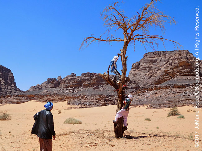
We continued following the line of the canyon eastward, with a brief stop to cut some firewood from a dead tree that was still standing in the middle of a oued. The local Tuaregs are very conscious of the fragility of their desert. We carefully cut only a few branches of the dead wood. Even downed wood plays a role in the eco system and a dead tree still standing can help to bind the soil. Overconsumption of firewood is a serious issue across large sections of Africa. The desert is a series of very fragile, delicately balanced ecosystems — often a mosaic of microclimates. Small hollows support vegetation that protects the land from the prevailing winds. In these marginal areas, human activity can stress the ecosystem beyond its tolerance limit, resulting in further degradation of the land. The collection of firewood reduces or eliminates plants that help to hold the soil in place. The Tuareg respect their land and we try to keep our impact to a minimum following a locally-adapted version of the Tread Lightly ethic. We use only a small amount of wood for our evening fire, and bury the partially burned pieces in the sand to dig up in the morning for use as charcoal en route. The wood we cut here will last us for the next few days.
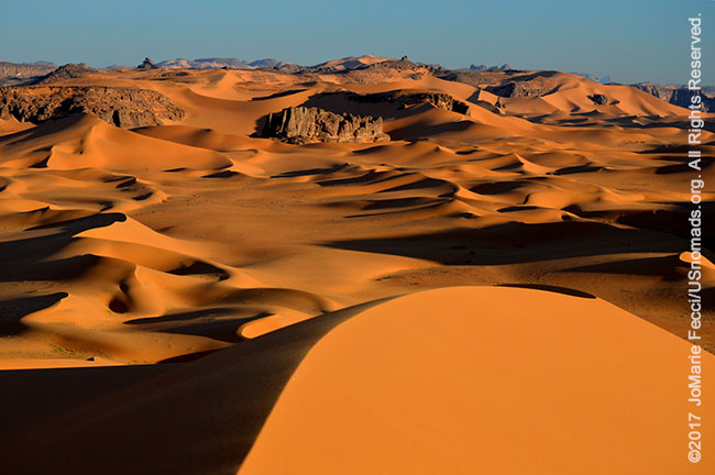
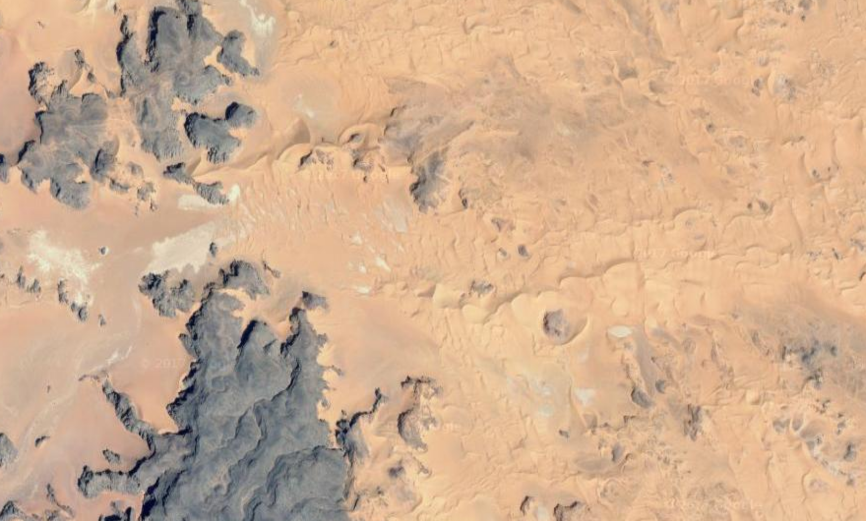
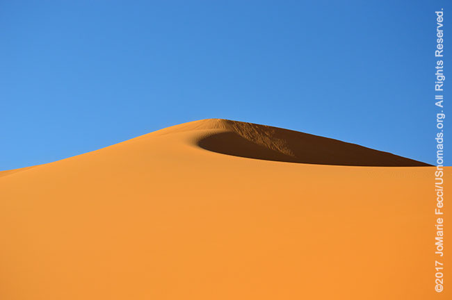
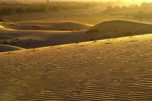
The shadows were growing longer as we reached the place where the canyon opened up on to a spectacular desert landscape unlike anything I had seen before — the black-blue-and-gold color scheme of the Sahara sculpted by the wind. Tall sand dunes seemed to rise up out of the flattest part of the desert in perfect golden curves, and interspersed right in the midst of the dunes were towering ragged rock formations of black sandstone. The whole scene was dramatically set off against a bright blue sky. The light was perfect. I was drawn into it as if by getting closer I could prove to myself that it wasn’t some kind of mirage.
The place, called “Wanta Berka,” was named after a Tamarisk tree which no longer stood according to the Tuareg. There seems to be a habit here of using landscape features for place-names, and the scarcity of trees in the desert often leads to them being referenced as landmarks. The most famous “landmark” tree, “l’Arbre du Ténéré” (“tree of the tenere”) located in Niger, is actually labelled on maps up to a scale of 1:4,000,000. A solitary acacia — the only one for over 400 kilometres (250 mi) — it was a waypoint on caravan routes for centuries. Ironically, it was knocked down in 1973, supposedly by a drunken Libyan truck driver.
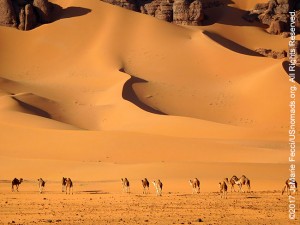
As we moved closer to the dunes we spotted a couple of camels on a distant crest. They were soon followed by a whole herd majestically crossing the desert as in a film. They were considered “wild” camels, though technically there is no such thing as “wild camels” in the Sahara. The designation of “wild” is reserved for a specific breed of Bactrian camels in northwest China and Mongolia. These free-roaming domesticated camels in Algeria would be more precisely referred to as a “feral” herd. But the distinction is academic — they were free and on their own in the wilderness and unused to human contact. And they were beautiful to watch.
Interestingly, the Sahara’s most iconic animal is actually not native to North Africa. The oldest cameloid fossils (which date back 50 million years) were found in North America. About two million years ago, a branch of the family crossed the Bering Strait land bridge into Asia and eventually Arabia. It arrived in the Sahara sometime around the first century, probably introduced by Arab traders. The camel, capable of ferrying people and goods across the desert through sun and sandstorms, quickly became indispensable.
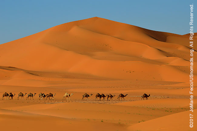
While the days of camel caravans are long gone, the animals remain an important measure of wealth in most parts of the Sahara, and it is rare to find camels that do not “belong” to someone, even if their owner is far away. We left the herd to graze and kept going towards the tall dunes to look for a good spot to set up camp for the evening. There was a protected bowl with a nice flat area that was already in shadow near the top of one of the higher dunes. A long run up gave us enough momentum to get the heavily laden truck to the spot. The sand was very soft, and a light wind was blowing it right off the crest creating a faint visual cloud of dust at the top of the highest dune.
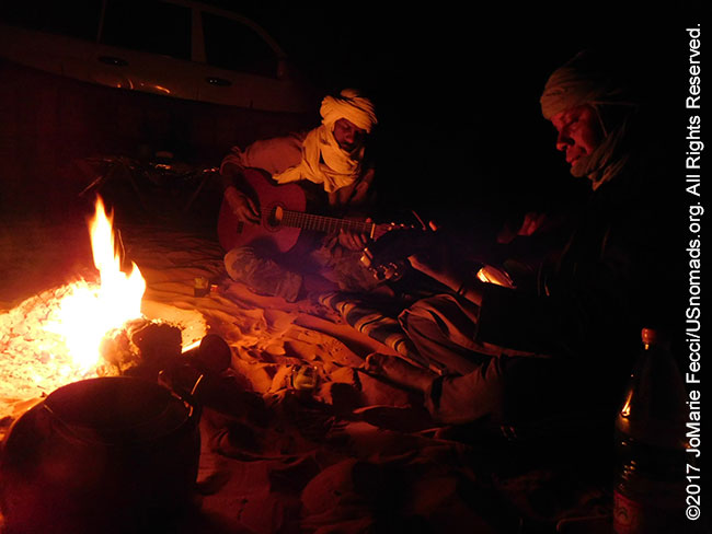
The evening chill set in as soon as the sun dropped below the cliff line and we got our fire burning quickly. With the first stars visible the team relaxed, strumming the familiar rhythms of the “desert blues” known as “assouf.” The musical style, made internationally famous by the band Tinariwen, is inspired by a sense of nostalgia for the desert itself. It developed in the 1970s and 80s as a rough, artisanal, homespun sound played on guitars that chronicled the uncertainties and isolation of modern life. In one generation the semi-autonomous rural nomadic society of the Tuareg had been transformed into a dependent semi-urban one. Families had been uprooted from the independence of the desert and forced to confront the alien realities of modern ‘civilisation’ that rendered the old hierarchies, customs and knowledge irrelevant. This music expressed the loneliness, the longing for a way of life lost forever, the pain deep in their hearts. They recorded songs onto cassettes which were endlessly re-copied and shared across the desert. By 2001 assouf went global, with Tinariwen’s first European tour.
The sound is rooted in the traditional beat of the tendé drum and the complex inflections of the teherdent, a three stringed lute played by the Tuareg and Songhoi griots of Gao and the Niger bend. The lyrics are modern poetry, and can be improvised on the spot in a fashion similar to urban rap. Saghd and Mohamed playfully mix the well-known lyrics of Tinariwen songs with their own accounts of events from the day going back and forth between Tamashak and French with ease. The music seems to echo in the desert night as the moon rises over the dunes and for the moment the ephemeral magic of the Sahara feels eternal.
> CONTINUE: THE JOURNEY TO IN DJAREN
< BACK: TO EL BERDJ | ALGERIA REPORT HOME | AHEAD: TO IN DJAREN >
WHERE WE ARE
The People’s Democratic Republic of Algeria, in North Africa is the largest country in Africa and the tenth-largest country in the world. With an area of 2,381,741 square kilometres (919,595 sq mi) it is one-quarter of the size of the entire United States and four times the size of France. Its capital and most populous city is Algiers, located in the country’s far north on the Mediterranean coast. It is bordered to the northeast by Tunisia, to the east by Libya, to the west by Morocco, to the southwest by the Western Saharan territory, Mauritania, and Mali, to the southeast by Niger, and to the north by the Mediterranean Sea. With a population of roughly 38,813,722, Algeria ranks 33rd in population worldwide. The majority of that population, which is a well-integrated mixture of Arab and indigenous Berbers, live in the northern, coastal region. The official language is Arabic though many people also speak French and/or one of the nation’s Berber dialects.
THE JOURNEY SO FAR
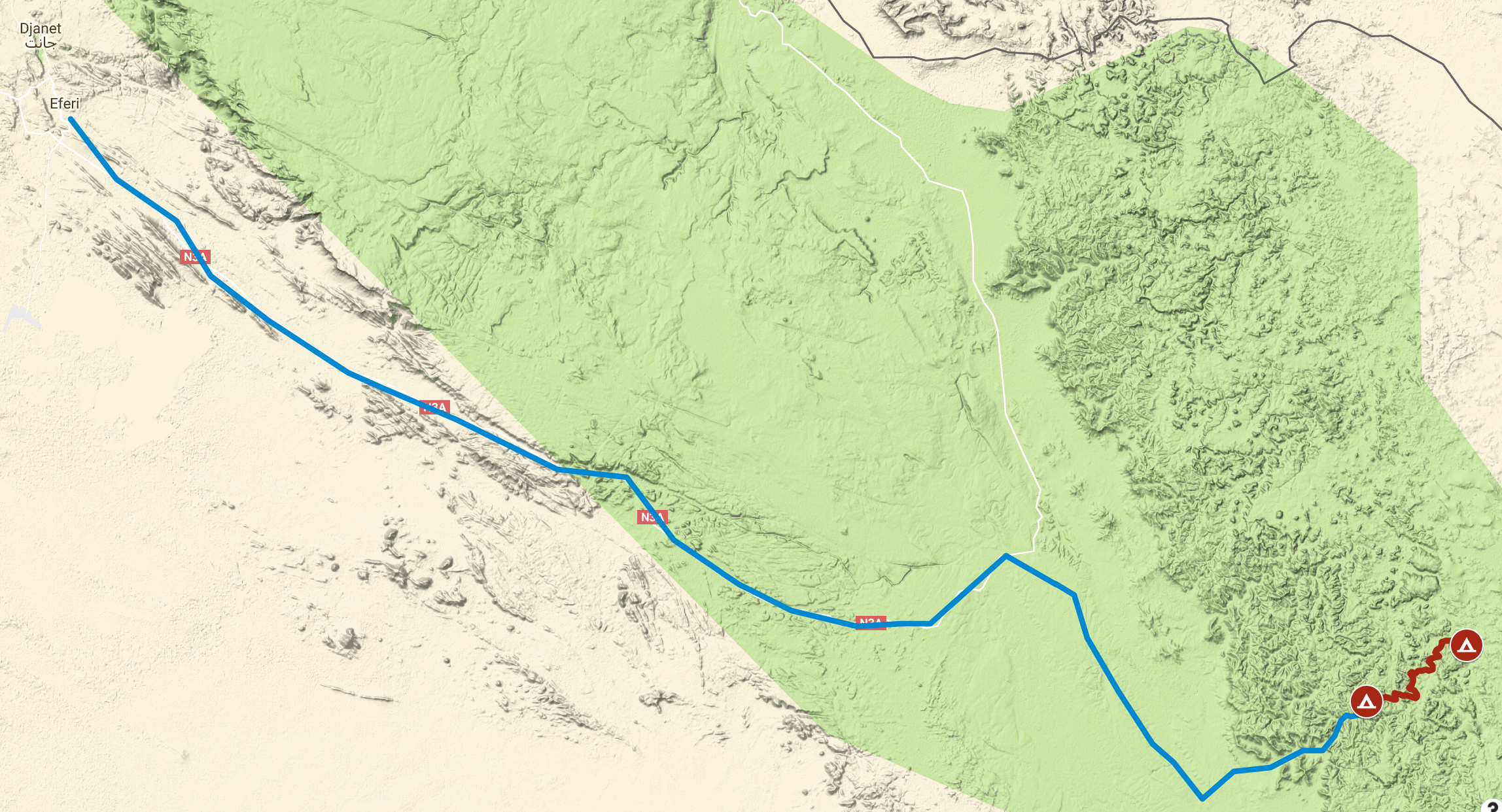
This map shows the progress of the team overall as we work our way around the Tassili N’Ajjer region from our starting point in Djanet. We have traveled a total of 135 miles since we began, and the red segment highlights today’s drive.
ABOUT THE DAY’S ROUTE
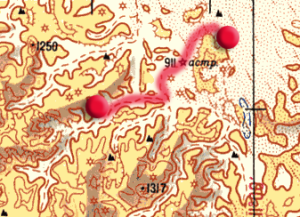
EL BERDJ TO WANTA BERKA – 15 miles –
(click map to view larger image)
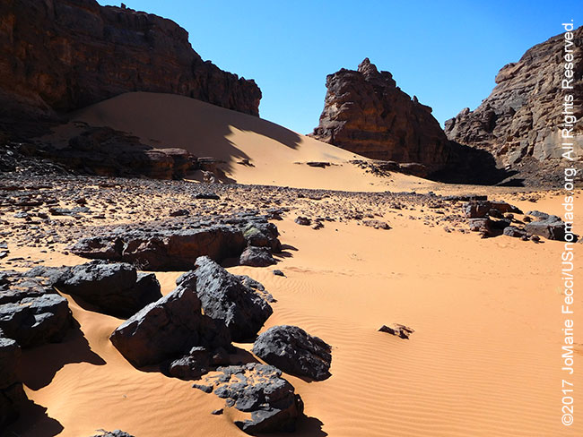
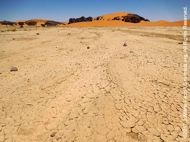
Today’s drive is short and relatively easy. Most of the day we remain within the confines of the narrow canyon of El Berdj, weaving our way north and east following the twists and turns of the largest central “stem.” Navigation can be tricky because from within, El Berdj seems very confusing and maze-like with all the off-shoot “dead-end” side canyons. Toward the end of the day the canyon opened up into a completely different type of terrain, a wide open field of dunes with corridors of soft sand and rock formations in between.
TERRAIN DETAIL: WANTA BERKA
(click map to view larger image)
Wanta Berka is where the canyon opens up into a section of sand dunes, with a few rock formations in between. At the base of the dunes the sand is solid, but the dunes themselves are quite soft and steep. It is possible to avoid driving over the dunes by following the route along the base between the edge of the rock walls and the dune field.
MAP RESOURCES
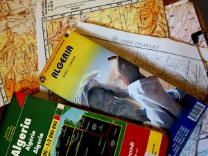
For general planning, a good overview map of Algeria that includes the southeast is this ITBM Algeria 1:2,000,000 scale road map. For detailed navigational planning we used the old Russian 1:500,000 topos that circulate online supplemented by US 1:250,000 tactical pilotage maps from the Perry-Castañeda Library Map Collection of the University of Texas at Austin. Note that these maps are “historical” and marked “not to be used for navigational purposes” but they make an excellent planning tool, as the basic topography does not change. For more on available maps for this part of Algeria and the Sahara generally, see the Sahara-Overland.com map page.
THE TADRART
The Tadrart region of the Algerian Sahara is dotted with gueltas, pre-historic rock paintings, strange rock formations and lofty dunes of virgin sand. The Algerian Tadrart is sometimes called the Tadrart Rouge for the spectacular orange color of the sands contrasting with the jagged dark red rock formations of the mountains. It is an extenstion of the Tadrart Akakus or Acacus Mountains that form a range in the Ghat District of western Libya, stretching north from the Algerian border for 100 kilometres (62 mi). Tadrart is the feminine form of “mountain” in the Berber languages. The Tadrat Rouge is the 100 km southern prolongation of the Libyan Tadrart Acacus. It reaches its maximum elevation of 1,340 m towards the southern end of the range at about 160 km southeast of Djanet.
TEMPERATURE FLUCTUATION
In meteorology, diurnal temperature variation is the variation between a high temperature and a low temperature that occurs during the same day. Temperature lag is an important factor in diurnal temperature variation: peak daily temperature generally occurs after noon, as air keeps net absorbing heat even after noon, and similarly minimum daily temperature generally occurs substantially after midnight, indeed occurring during early morning in the hour around dawn, since heat is lost all night long. The extreme fluctuations are due to the lack of plant life and the absence of humidity in the desert. Plants absorb sunlight and retain heat. Humidity, or water in the atmosphere also maintains warmth. The atmospheric water traps heat near the surface of the earth, holding it there even after the sun sets. This prevents the surface from cooling rapidly at night. Less atmospheric water means more heat can escape into space, cooling the surface.
FORMATION OF THE SAHARA
At over 9,400,000 square kilometers, the Sahara covers nearly 10 percent of the African continent, including Algeria, Chad, Egypt, Libya, Mali, Mauritania, Morocco, Niger, Sudan and Tunisia. The movement of tectonic plates that created the Mediterranean Sea and the Alps also sparked the drying of the Sahara some 7 million years ago, according to the latest computer simulations of Earth’s ancient climate. The desert was formed when a giant ocean, known as the Tethys, began to shrink. The Tethys was the origin of the modern Mediterranean, Black and Caspian Seas. As it shrunk, North Africa dried out and changed from a permanently lush, vegetated landscape to the arid desert we know today. Subtle changes in Earth’s tilt toward the sun periodically increase the amount of solar energy received by the Northern Hemisphere in summer, altering atmospheric currents and driving monsoon rains. North Africa also sees more precipitation when less of the planet’s water is locked up in ice. Such increases in moisture limit how far the Sahara can spread and can even spark times of a “green Sahara”, when the sparse desert is replaced by abundant lakes, plants and animals. The Neolithic Subpluvial, or the Holocene Wet Phase, was an extended period (from about 7500–7000 BCE to about 3500–3000 BCE) of wet and rainy conditions in the climate history of northern Africa. During this period existing lakes had surfaces tens of meters higher than today, sometimes with alternative drainages: Lake Chad reached a maximum extent of some 400,000 square kilometers in surface area, larger than the modern Caspian Sea, with a surface level about 30 meters (100 feet) higher than its twentieth-century average. Some shallower lakes and river systems existed in the subpluvial era that later disappeared entirely, and are detectable today only via radar and satellite imagery. North Africa had a savanna type of ecosystem, with elephant, giraffe, and other grassland and woodland animals now typical of the Sahel region south of the desert. According to historian and Africanist Roland Oliver, the highlands of the central Sahara Desert were covered with forests of oak and walnut, lime, alder and elm. The Tassili had olive, juniper and Aleppo pine. In the valleys, perennially flowing rivers teemed with fish and were bordered by seed-bearing grasslands. The desertification caused by climate change was likely made worse by human actions. The introduction of domesticated animals correlates in many places to a rapid change from grassland to scrubland vegetation, and it is hypothesized that Neolithic humans may have potentially played a role in stripping vegetation from the landscape, which induced cascading effects to the ecosystem and climate.
TASSILI N’AJJER
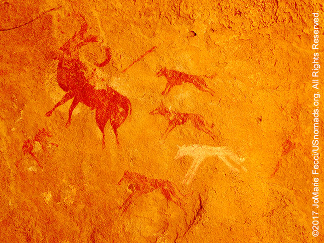
The Tassili N’Ajjer was inscribed as a UNESCO World Heritage site in 1982. The site is listed under both natural and cultural criteria, and, from a cultural perspective ranks as the premier rock-art site anywhere in the world. It is the home of more than 15,000 rock paintings and engravings, This incredible open-air gallery tells the story of the changing fortunes of this part of the Sahara and the people who have occupied the area over the millennia. It is a story that traces the environmental effects of climate change which can be divided into distinct periods according to the characteristics of the rock-art legacy. The oldest art belongs to the so-called Wild Fauna Period (10,000-6,000 BC) characterised by the portrayal of animals – elephants, giraffes, hippos and rhinos – that inhabited the area when it was much wetter than today. Overlapping with this era is the Round Head Period (8,000-6,000 BC) when human figures appear alongside painted circular heads devoid of features. At this time people were living as hunter-gatherers, but this gradually gave way to the Pastoral Period (5500-2000 BC) characterised by art that depicts the introduction of domesticated cattle, and a more settled existence with human figures handling spears and performing ceremonies. As the climate became progressively drier and long-distance travel more important, the art of the Horse Period (1000 BC – AD 1) shows the introduction of horses and horse-drawn chariots. Finally, the most recent period of rock-art in the Sahara (from about 200 BC to present) is the Camel Period, as these animals have played an increasingly important role. The area of Tassili has an entire range of Saharan landscapes, from the desert’s lofty dunes and sculptured rocks to its life-giving gueltas (water-holes and small lakes). Tassili – “plateau of the rivers” in Arabic.
SAHARAN CLIMATE AND HUMAN MIGRATION
Human habitation in North Africa has been greatly influenced by the climate of the Sahara, which has undergone enormous variations between wet and dry over the last few hundred thousand years. This is due to a 41,000-year cycle in which the tilt of the earth changes between 22° and 24.5°. During the last glacial period, the Sahara was much larger than it is today, extending south beyond its current boundaries. The end of the glacial period brought more rain to the Sahara, from about 8000 BC to 6000 BC, perhaps because of low pressure areas over the collapsing ice sheets to the north. Once the ice sheets were gone, the northern Sahara dried out. In the southern Sahara, the drying trend was initially counteracted by the monsoon, which brought rain further north than it does today. By around 4,200 BC, however, the monsoon retreated south to approximately where it is today, leading to the gradual desertification of the Sahara. As the savanna grasslands turned to desert, the flora and fauna retreated northwards to the Atlas Mountains, southwards into West Africa, or eastwards into the Nile Valley. The human population followed, migrating in waves north, south and eastward.
ENDLESS DESERT
Though the Sahara is not actually the world’s largest desert (Antartica is), it is massive — and is increasing in size every year due to desertification. According to the Conservation Institute, the Sahara now comprises eight percent of the world’s land area — one could place the entire continental U.S. within the Sahara and still have a few thousand square miles of desert left over. However, despite it’s size, it is not very populated. The U.S. is home to 300 million individuals, while the Sahara counts just two million inhabitants. That’s a population density of only 1/150th of the U.S.
NOTE: This is the third in a series of segments highlighting details of a two-week scouting trip in the south-east of Algeria. All text and photos are copyright JoMarie Fecci/USnomads unless otherwise noted. If you would like to use any imagery here, please contact us for permission. The trip was conducted in April 2017 by JoMarie Fecci of US Nomads with a local Djanet-based team. For more information about the specifics contact us.